


Click Image to Enlarge
Kentucky Counties
Kentucky has one hundred and twenty counties, third in the US behind Texas's (254) and Georgia's (159.) Washington County was the first county formed in the Commonwealth of Kentucky when it reached statehood, and the sixteenth county formedHopkins County, Kentucky
Hopkins County Education, Geography, and History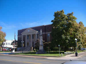
Hopkins County is a county located in the state of Kentucky. Based on the 2010 census, the
population was 46,920. Hopkins County was
created on December 9, 1806. The county
seat is
Madisonville. Hopkins county is named for General Samuel Hopkins, an officer in both the American Revolutionary War and War of
1812, and later a Kentucky legislator and United States Congressman.
The Madisonville, KY Micropolitan Statistical Area includes all of Hopkins County.
Etymology - Origin of Hopkins County Name
Hopkins county is named for General Samuel Hopkins (1753-1819), officer in both the Revolutionary War and War of 1812, a Kentucky legislator and a United States congressman.
Demographics:
County QuickFacts: CensusBureau Quick Facts
Hopkins County History
The earliest inhabitants were prehistoric Native Americans who lived, hunted, and farmed in the region. One of their settlements was a
rough stone structure on Fort Ridge, which has since been destroyed by strip mining for coal. Some of the early settlers were Revolutionary
War veterans who received land grants for their service from Virginia in the area southwest of the Green River. Among these was Baron Von
Steuben, a Prussian general who had trained George Washington's Continental Army at Valley Forge during the winter of 1776-77. He had received
a grant of several thousand acres in the northwest part of the county. According to tradition, Von Steuben was wounded in an Indian attack on
his first visit to Kentucky. He then quit-claimed his property. Nevertheless, a salt spring on his grant came to be known as Steuben's Lick.
By the 1880s, the community that grew up around the lick was known as Manitou.
Roads in the county often followed animal trails that led to salt and mineral springs. The major traces were those ones connected the county
seat at Madisonville with Henderson to the north, Hopkinsville to the south, and Russellville to the southeast. Numerous other trails led to
the mills and ferries on the Pond and Tradewater Rivers and their tributaries.
Hopkins county was formed in 1807. Hopkins County was divided by the American Civil War. Union supporters joined the 35th Kentucky Mounted Infantry, a regiment recruited locally by James M. Shackelford, while Adam Rankin Johnson had earlier recruited Confederate troops for his 10th Kentucky Cavalry Regiment. The courthouse in Madisonville was burned by Kentucky Confederates led by Gen. Hylan Benton Lyon on December 17, 1864, as they passed through western Kentucky, since it was being used to house Union soldiers. However, the harsh policies imposed by the occupying Union armies caused much more resentment and served to increase the sympathy for the Confederate cause. Ever since then, local politics have been heavily dominated by the Democratic party.
In 2000 the county population was 46,519 in a land area of 550.56 square miles, an average of 84.5 people per square mile. The county seat is Madisonville.
Geography: Land and Water
As reported by the Census Bureau, the county has a total area of 554 square miles (1,430 km2), of which 542 square miles (1,400 km2) is land and 12 square miles (31 km2) (2.2%) is water. The elevation in the county ranges from 345 to 729 feet above sea level.
Hopkins county is located in west Kentucky. This county is located in the Western Coal Field region of the state. The land is flatlands along the broad river valleys of the Pond River, Tradewater River, and Green River, and hilly and rolling land in the southern and central parts of the county.
Neighboring Counties
Bordering counties are as follows:
- Northeast: McLean County
- Southeast: Muhlenberg County
- South: Christian County
- Southwest: Caldwell County
- Northwest: Webster County
Education
Two public school districts operate in the county. Hopkins County Schools serves most of the county, except for the city of Dawson Springs, which is covered by the Dawson Springs Independent School District. The Dawson Springs district operates a single K-12 facility, Dawson Springs Community School.
High schools
Hopkins County Central High School
Madisonville North Hopkins High School
Dawson Springs Community School
Grace Baptist
Community College
Madisonville Community College


Click Image to Enlarge
