


Click Image to Enlarge
Kentucky Counties
Kentucky has one hundred and twenty counties, third in the US behind Texas's (254) and Georgia's (159.) Washington County was the first county formed in the Commonwealth of Kentucky when it reached statehood, and the sixteenth county formedRussell County, Kentucky
Russell County Education, Geography, and History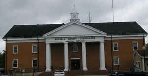
Russell County is a county located in the US Commonwealth of Kentucky. Based on the 2010 census, the population was 17,565. The county was formed on December 14, 1825. The county seat is Jamestown. Russell county is named for Colonel William Russell.
Etymology - Origin of Russell County Name
Colonel William Russell (1758-1825), Revolutionary War officer, Indian fighter, commander of American forces on the frontier, and Kentucky legislator.
Demographics:
County QuickFacts: CensusBureau Quick Facts
RussellCounty History
Russell county was formed in 1826. The county is located in the Pennyrile region of the state. In 2000 the county population was 16,315 in a land area of 253.53 square miles, an average of 64.4 people per square mile. The county seat is Jamestown. This county is a prohibition or dry county, meaning that the sale of alcohol is restricted or prohibited.
Geography: Land and Water
As reported by the Census Bureau, the county has a total area of 283 square miles (730 km2), of which 254 square miles (660 km2) is land and 29 square miles (75 km2) (10%) is water. The elevation in the county ranges from 530 to 1140 feet above sea level. The highest point is 1,140 feet (350 m) atop Dickerson Ridge in the extreme northern part of the county and the lowest point is 530 feet (160 m) along the Cumberland River.
Russell county is located close to the center of Kentucky. Wolf Creek Dam is located in this county. The dam includes Cumberland River to form Lake Cumberland. Wolf Creek National Fish Hatchery is also located in Russell County just below the dam. The Lake, formed by the Cumberland River and Wolf Creek Dam, has over 1200 miles of shoreline and is the third largest lake east of the Mississippi.
Neighboring Counties
Bordering counties are as follows:
- Northeast: Casey County; Pulaski County
- Southeast: Wayne County
- South: Clinton County
- Southwest: Cumberland County
- Northwest: Adair County
Education


Click Image to Enlarge
