

Click Image to Enlarge
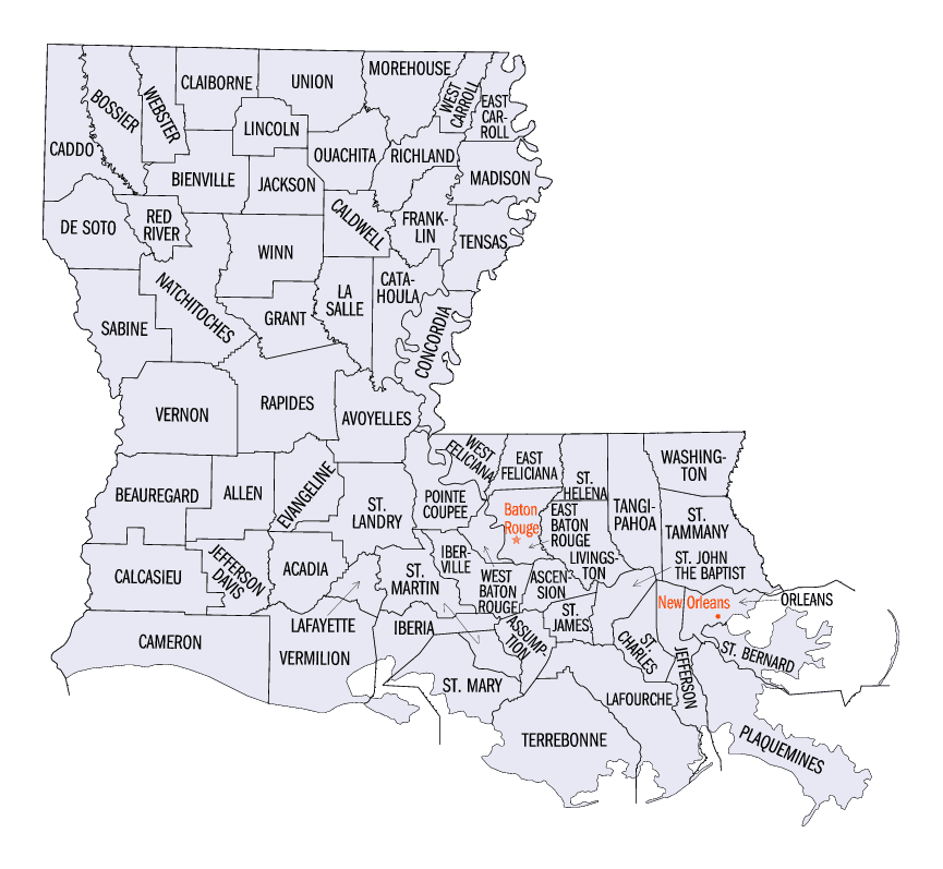
Louisiana Parishes
Louisiana is divided into sixty-four parishes. On March 31, 1807, the territorial legislature divided the state into 19 parishes, without getting rid of the old counties (which continued to exist until 1845). In 1811, a constitutional convention organized the state into seven judicial districts, each consisting of groups of parishes. In 1816, the first official map of the state used the term, as did the 1845 constitution. Since then, the official term has been parishes.St. Charles Parish, Louisiana
St. Charles Parish Education, Geography, and History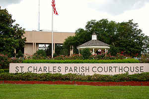
St. Charles Parish is a parish located in the state of Louisiana. Based on the 2010 census, the population was 52,780. The parish seat is
Hahnville. The parish was formed in 1807. It was originally part of the German Coast, an area along the east bank of the Mississippi River
that was settled by numerous German pioneers in the 1720s.
St. Charles Parish is included in the New Orleans-Metairie, LA Metropolitan Statistical Area.
Etymology - Origin of St. Charles Parish Name
The parish was named in honor of Saint Charles
Demographics:
County QuickFacts: CensusBureau Quick Facts
St. Charles County History
St. Charles Parish was created on March 31, 1807. It is one of the 19 parishes, which were created by dividing the Territory of New Orleans. The parish was named in honor of Saint Charles. The Parish seat is Hahnville.
St. Charles Parish, one of the original 19 parishes of the territory of Orleans, was created in 1807 from the county
of the German Coast. The "Cote des Allemands" or German Coast begins 25 miles above the city of New Orleans and extends
along both sides of the Mississippi River for 40 miles toward Baton Rouge. Today, this incorporates all or part of St.
Charles and St. John the Baptist Parishes
In 1720, twenty-one German families from the Rhine region of Germany settled on the West Bank of the Mississippi river.
These families had suffered horribly during the Thirty Years War and subsequent French Occupation, and had fled by the
thousands to the New World, enticed by promises of great wealth promoted by John Law. These original German settlers
were given small plots of land by Mr. Law's Company of the Indies, a few primitive tools, and in return found hardships
in lieu of the promised great wealth.
In 1721, 330 German immigrants led by a Swedish officer named Karl Friedrich D'Arensbourg, who worked for the Company of
the Indies, arrived in Louisiana. Mr. D'Arensbourg was to play a vital role in the history of the German Coast as well
as that of New Orleans. In 1722, Germans from John Law's Arkansas Concession arrived in New Orleans demanding passage to
Europe. Due to a lack of ships and supplies, Louisiana Governor Bienville persuaded them to remain, and they eventually
joined the other Germans along the banks of the River.
The census of 1731, approximately 10 ? years after the establishment of the settlement, shows that there were no farm
animals in the settlement. This is evidence that the first settlers endured hardships in farming, as the land which was
used for farming was all cleared by hand, and done under the most primitive of conditions. In 1765 and 1766, the first
Acadians arrived in the area, and they too were given land along the River, and joined the Germans in raising the fruits
and produce that was used to feed the city of New Orleans.
Besides the fruit and vegetables grown for the marketplace in New Orleans, tobacco and indigo were grown on the German
Coast. Due to the large amount of swamp area containing many cypress trees and a large number of live oak trees in the
area, lumber was also a thriving business venture.
By 1792 when Destrehan Plantation became the property of Jean Noel Destrehan and his wife Marie Celeste Eleanor Robin
deLogny, the German Coast contained a rich mixture of Germans, French Creoles, French Acadians and Free Blacks. During
this decade, both Ormond Plantation on the East Bank, and Homeplace on the West Bank were built.
The lands along the German Coast are flat, and slope from approximately 14 feet above natural sea level at the banks of
the Mississippi River, to approximately 1 foot above sea level at the shore of Lake Pontchartrain. Because the last 4 to
5 miles of land toward the lake are flat, level swampland that gives way to marsh as it approaches the lake, only 3 to 4
miles of land closest to the banks of the River was suitable for cultivation. As a result, the first serious attempts at
levee building began around 1743. Though each land owner was responsible for building and maintaining levees along his
property, these levees were usually only about 5 feet high and the area suffered disastrous floods almost yearly.
In 1928, test pilings were driven, and a controlled outlet for the flooding Mississippi River was created, aptly named
the Bonnet Carre Spillway. The Spillway was opened just in time, for in January of 1937 one of the greatest of all
recorded floods started on its way down the Mississippi River. In February, the Carrolton gauge registered 20 feet, and
the spillway was opened for the first time. The great levee experiment was successful, and the area remained high and
dry. Now, thanks to the protection provided by the Bonnet Carre Spillway, River flooding is virtually unknown in the
Parish.
In 1803, Louisiana was sold to the United States in the largest peacetime land acquisition in the history of the world.
For only $15 million dollars, the United States purchased most of the land from the Canadian border to the Gulf of
Mexico, and straddling the continent from the Mississippi River to the Rocky Mountains. The present boundaries of the
state were set, and Louisiana was admitted to the Union in 1812.
In 1853, a major yellow fever epidemic struck New Orleans and its effects were felt along the German Coast. During this
time, the priest at the Little Red Church (so named for its red roof that served as a distance marker for watermen on
their way to the Port of Orleans) was a Frenchman named father Paret.
On the heels of the Yellow Fever Epidemic in 1861, Louisiana seceded from the Union and joined the Confederacy. During
the War Between the States, St. Charles Parish was the scene of several skirmishes, but no large battles were fought in
this area. By 1864, the area had two governors, one Confederate and one Federal. The Federal Governor was Michael Hahn
who later founded Hahnville, now the seat of St. Charles Parish's local government.
By the early 1900's, industry started moving into the Parish. In 1907, the first sawmill in the Parish opened in Taft,
the home of the Colonial Dairy Farm, one of the largest dairies in the state. In 1908, the Louisiana Cypress Company
began to harvest cypress in the area. The Cousins Canal was dug, and by 1912, over 100,000 feet of board lumber was
floated out of it.
With the discovery of oil at Jennings Field around the turn of the century, a new area of economic opportunity opened up
along the German Coast. In 1914, Destrehan Plantation was sold to the Mexican Petroleum Company and it became the first
of the River Road Plantations to change from an agricultural to an industrial economic base. Through a series of
buy-outs and mergers, the house became the property of the American Oil Company, and the "Big House" was deeded by AMOCO
to the River Road Historical Society for preservation.
With the coming of the oil refineries, related industries also located in the Parish. First, was an oil export terminal
owned by Cities Service Company, located in St. Rose in 1922, followed in 1925 by General American Transportation
Corporation and Coatwise Petroleum in Good Hope.
Oil was discovered in St. Charles Parish in 1938 at Bayou Des Allemands, Paradis in 1939, Lake Salvador in 1940 and
Bayou Couba in 1942. The 1950's saw the opening of Monsanto and Lion Oil Co. In Luling, Shell Chemical, Union Carbide
(Dow St. Charles Operations), Hooker Chemical (Occidental Chemical), and the Bunge and St. Charles Grain elevators.
Although the old plantation homes are gone, their names live on the location of the sites of many of these industries.
Geography: Land and Water
As reported by the Census Bureau, the parish has a total area of 411 square miles (1,060 km2), of which 279 square miles (720 km2) is land and 132 square miles (340 km2) (32%) is water.
Neighboring Parishes
Bordering parishes and counties are as follows:
- Northeast: Lake Pontchartrain
- Southeast: Jefferson Parish
- Southwest: Lafourche Parish
- Northwest: St. John the Baptist Parish
Education
St. Charles Parish Public Schools operates public schools


Click Image to Enlarge
