

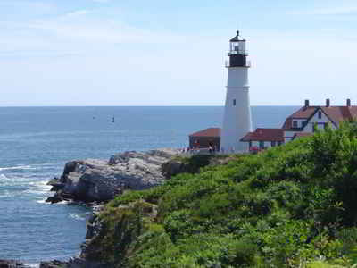
Click Image to Enlarge
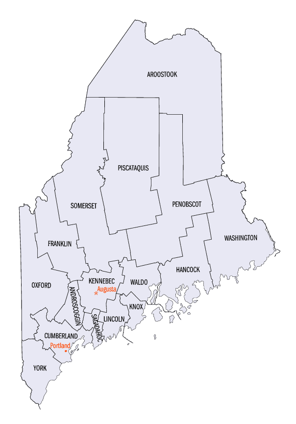
Maine Counties
There are sixteen Counties in Maine. Prior to statehood. The first county to be created was York County, created as York County, Massachusetts by the government of the Massachusetts Bay Colony in 1652. Maine was granted statehood on March 15, 1820 as part of the Missouri Compromise. Nine of the sixteen Counties had their borders defined while Maine was still part of Massachusetts, and hence are older than the state itself. Even after 1820, the exact location of the northern border of Maine was disputed with Britain, until the question was settled and the northern counties took their final, official form by treaty in 1845.Maine Counties: History and Information
Find a brief history of Maine Counties
The State of Maine is a state in the New England region of the northeastern United States of America, bordering the Atlantic Ocean to the southeast, New Hampshire to the southwest, the Canadian provinces of Quebec to the northwest and New Brunswick to the northeast. Maine is the northernmost portion of New England and is the easternmost state in the contiguous United States. It is known for its scenery- its jagged, mostly rocky coastline; its low, rolling mountains; and its heavily forested interior - as well as for its seafood cuisine, especially lobsters and clams.
This is a list of the sixteen counties in the state of Maine. Before statehood, Maine was officially part of the state of Massachusetts and was called the District of Maine. Maine was granted statehood on March 15, 1820 as part of the Missouri Compromise. Nine of the sixteen counties had their borders defined while Maine was still part of Massachusetts, and hence are older than the state itself. Even after 1820, the exact location of the northern border of Maine was disputed with Britain, until the question was settled and the northern counties took their final, official form by the Webster-Ashburton Treaty, signed in 1842. Almost all of Aroostook County was disputed land until the treaty was signed.
The first county to be created was York County, created as York County, Massachusetts by the government of the Massachusetts Bay Colony in 1652 to govern territories it claimed in southern Maine. No new counties have been created since 1860, when Knox County and Sagadahoc County were created. The most populous counties tend to be located in the southwestern portion of the state, along the Atlantic seaboard. The largest counties in terms of land area are inland and further north. Maine's county names derive from a mix of British, American, and Native American sources, reflecting Maine's pre-colonial, colonial, and national heritage.
| Find a brief history of Maine Counties | ||||
|---|---|---|---|---|
| County | 2000 Population |
Square Miles |
County Seat | Created |
| Androscoggin County | 103,793 | 470 | Auburn | 1854 |
| Aroostook County | 73,938 | 6,672 | Houlton | 1839 |
| Cumberland County | 265,612 | 836 | Portland | 1760 |
| Franklin County | 29,467 | 1,698 | Farmington | 1838 |
| Hancock County | 51,791 | 1,589 | Ellsworth | 1789 |
| Kennebec County | 117,114 | 868 | Augusta | 1799 |
| Knox County | 39,618 | 366 | Rockland | 1860 |
| Lincoln County | 33,616 | 456 | Wiscasset | 1760 |
| Oxford County | 54,755 | 2,078 | South Paris | 1805 |
| Penobscot County | 144,919 | 3,396 | Bangor | 1816 |
| Piscataquis County | 17,235 | 3,966 | Dover-Foxcroft | 1838 |
| Sagadahoc County | 35,214 | 254 | Bath | 1854 |
| Somerset County | 50,888 | 3,927 | Skowhegan | 1809 |
| Waldo County | 36,280 | 730 | Belfast | 1827 |
| Washington County | 33,941 | 2,569 | Machias | 1789 |
| York County | 186,742 | 991 | Alfred | 1636 |

Click Image to Enlarge
