

Click Image to Enlarge
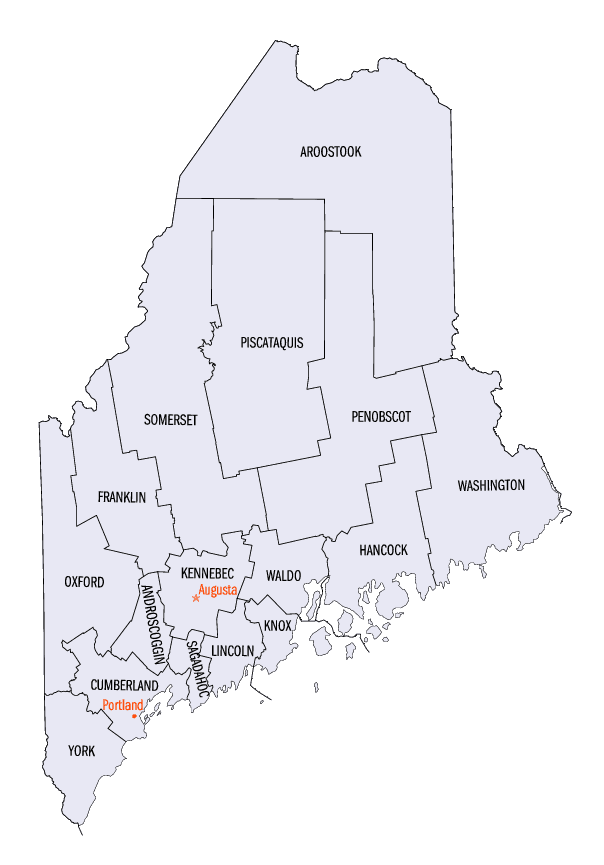
Maine Counties
There are sixteen Counties in Maine. Prior to statehood. The first county to be created was York County, created as York County, Massachusetts by the government of the Massachusetts Bay Colony in 1652. Maine was granted statehood on March 15, 1820 as part of the Missouri Compromise. Nine of the sixteen Counties had their borders defined while Maine was still part of Massachusetts, and hence are older than the state itself. Even after 1820, the exact location of the northern border of Maine was disputed with Britain, until the question was settled and the northern counties took their final, official form by treaty in 1845.Androscoggin County, Maine
Androscoggin County Education, Geography, and History
Androscoggin County is a county located in the state of Maine. As of the 2010 US Census, the county's population was 107,702.Its
county seat is Auburn.
Androscoggin County comprises the Lewiston-Auburn, Maine Metropolitan Statistical Area and partially included within the Lewiston-Auburn,
Maine, Metropolitan New England City and Town Area. It is also a part of the Portland-Lewiston-South Portland, Maine Combined Statistical
Area.
Etymology - Origin of Androscoggin County Name
Androscoggin is named for the Androscoggin Native American tribe.
Demographics:
County QuickFacts: CensusBureau Quick Facts
Androscoggin County History
History of Androscoggin County, Maine
From: A Gazetteer of the State of Maine
By Geo. J. Varney
Published by B. B. Russell, 57 Cornhill,
Boston 1886
Androscoggin County lies in the midst of the southwestern section of Maine, having its greatest length from north
to south. The Androseoggin River passes through it longitudinally, dividing it into two nearly equal parts. The
county derives its name from that ot the river, which is a corruption of Anasagunticook, the name of the Indian
tribe which formerly occupied the region. It contains the larger proportion of the practically available water power
of the Androscoggin and its tributaries, including three of the greatest powers on the main river.
The county buildings are at Auburn, where, too, the courts are held. The county was organized March 18th, 1854;
having gained its territory from five other counties. Auburn, Danville (the latter since annexed to the former),
Durham, Polani and Minot were taken from Cuinberland County; Livermore and Turner from Oxford County; East
Livermore, Leeds, Greene, and Wales from Kennebec and Lewiston, Webster and Lisbon, from Lincoln. The county
contains eleven towns and two cities, most of them thrifty and several of them exceedingly flourishing. These are
the cities of Auburn and Lewiston and the towns of Durham, East Livermore, Green, Leeds, Lisbon, Livermore, Minot,
Poland, Turner, Wales and Webster.
The area of the county is about 400 square miles. The population in 1870 was 35,866; in 1880, it was 45,063. The
value of estates in 1870 was $17,592,555. In 1880, it was $20,776,973.
The surface of the country is in general very uneven, having many high hills, but no mountains. Its ponds, springs
and rivulets are numerous. Within its limits are Auburn Lake, Androscoggin, Sabattus, Taylor, Thompson, and Trip
Ponds, and the noted mineral springs of Poland, West Auburn and Lewiston. There are few extensive bogs, and there is
little other waste land. The agricultural qualities of the County are not surpassed in the southern half of the
State, and its manufactures are more extensive than that of any other county. Ihe Grand Trunk Railroad, with its
Lewiston and Auburn branch, the Buckfield and Rumford Falls Railroad, the Maine Central Railroad, with its
Androscoggin and Farinington branches, afford superior facilities for travel and commerce within and beyond its
borders. Unusual interest has been taken in education. Bates College is rapidly advancing to a first-class
institution ; and to it is now added a Theolagical and a fitting-school. Hebron Academy, in Hebron, has long had an
excellent reputation, while the Auburn and Lewiston schools from primary to high are probably not surpassed in the
State. One of the most excellent and influential newspapers of the State is published within its borders, and
through its public men it has for several years had a marked influence in the nation. There is still greater
development and a happy promise of the future before it....Androscoggin
County
Geography: Land and Water
As reported by the Census Bureau, the county has a total area of 497 square miles (1,288 km2), of which, 470
square miles (1,218 km2) of it is land and 27 square miles (70 km2) of it (5.42%) is water.
Neighboring Counties
Bordering counties are as follows:
- Franklin County, Maine - north
- Kennebec County, Maine - northeast
- Sagadahoc County, Maine - southeast
- Cumberland County, Maine - south
- Oxford County, Maine - west
Education
Bates College is located in the Androscoggin County city of Lewiston.


Click Image to Enlarge
