

Click Image to Enlarge
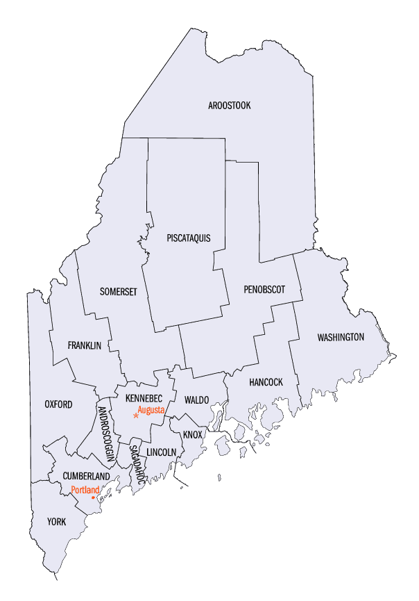
Maine Counties
There are sixteen Counties in Maine. Prior to statehood. The first county to be created was York County, created as York County, Massachusetts by the government of the Massachusetts Bay Colony in 1652. Maine was granted statehood on March 15, 1820 as part of the Missouri Compromise. Nine of the sixteen Counties had their borders defined while Maine was still part of Massachusetts, and hence are older than the state itself. Even after 1820, the exact location of the northern border of Maine was disputed with Britain, until the question was settled and the northern counties took their final, official form by treaty in 1845.Penobscot County, Maine
Penobscot County Education, Geography, and History
Penobscot County is a county located in the state of Maine. Based on the 2010 census, the population was 153,923. Its county seat is
Bangor. The county was established on 15 February 1816 from a portion of Hancock County when the area was still part of Massachusetts.
Penobscot County comprises the Bangor, ME Metropolitan Statistical Area.
Etymology - Origin of Penobscot County Name
Penobscot is named for the Penobscot Native American tribe.
Demographics:
County QuickFacts: CensusBureau Quick Facts
Penobscot County History
History of Penobscot County, Maine
From: A Gazetteer of the State of Maine
By Geo. J. Varney
Published by B. B. Russell, 57 Cornhill,
Boston 1886
Penobscot County in its shape appears like many rectangles of various size and form joined in one. Its southern
section lies a little south-east of the centre of the State, its eastern extends to within about 25 miles of New
Brunswick, while it also sends northward on a line with Penobscot River a parallelogram whose northern line
continued to our eastern boundary would fall but little more than. one township south of Mars Hill. Its southern
line is divided about midway by the Penobscot River at a discance of some sixty miles from the southern coast-line
of the State; and this river continues to be, in the main, the medial line for the entire length of the county.
Within its borders are many small but few large bodies of water. Pushaw Lake, just north of Bangor, is the largest
sheet wholly within this county; Newport Pond at the western border, and Cold Stream Pond on the eastern side of
Penobscot River being next in size, respectively 8, 7? and 6 square miles in area. At the south-eastern angle lies
the Lower Schoodic group, while at the western line begin the large and numerous lakes of the West Branch of the
Penobseot. The largest body of water within the county is found in Milinokett Lake, whose area is 18 square miles.
The western edge of this lake lies in Piscataquis County, but five-sixths are in Penobscot. Other considerable
rivers having some portion of their length in this county are Aroostook River, which is formed in the northern part;
the Piscataquis River, draining the southern part of Piscataquis County; the Nattawamkeag, fed from south-eastern
Aroostook; and above all the West Branch of the Penobseot, drawing its waters from a succession of lakes in northern
Piscataquis and quite from the summits. of the western hills that divide Maine from Canada, and send down rills to
the Connecticut and St. Lawrence. Some portions of the county are quite hilly, but the only mountains of note are
the Chase group northeast of Katahdin, and belonging to the same system. In the middle portion of the county there
is much slate rock, in the north-eastern portion there is granite, and in the southern, a large tract of argillo-.
micaceous schist.
Penobscot County was originally included in Hancock County. The act establishing it passed the Massachusetts
legislature Feb. 15, 1816. The southern boundary was fixed very much as it remains at present; but on the formation
of Piscataquis County in 1838, Penobscot lost 5 ranges of townships north of the lines of Dexter and Brad. tord; and
the following year Aroostook County received from it the ranges of townships numbered 3, 4 and 5, north of
Mattawamkeag; and in 1843, it took ranges 6, 7 and 8, north f townships numbered 8. The area is now 2,760 square
miles; and it embraces one city and 54 towns, 7 organized plantations and 42 townships. From 1814 to 1816 Bangor and
Castine were half shire towns of Hancock County; but in Penobscot County, Bangor had the exclusive honor from its
establishment. The population in 1870 was 75,150. In 1880 it was 70,478. The valuation in 1870 was $22,697,890. In
1880 it was $21,408,151.
Penobscot River and County were occupied, at the periods of discoverv and settlement, by a branch of the Abenaqui
nation called Tarratines by the Enghish, of whom the Oldtown Indians are a remnant. When first known by the English
they numbered more than 2,000 warriors. About 1680 there was a destructive war between the New England Indians and
the Mohawks; and tradition asserts that the Tarratines took part in it, but were defeated, and in 1669 were followed
to the banks of the Penobscot by their victorious foes. The principal settlement of this tribe was near the mouth of
the Kenduskeag. The Penobscot Indians do not appear to have entered as a tribe into the first Indian war, but were
actively engaged in most of the subsequent ones. In the war of the Revolution they fortunately adhered to the
American cause, and rendered it some service. Roman Catholic missionaries came with the first French visitors, and
mingling with the Indians, ere long converted them to that faith.
The General Assembly of Massachusetts in 1763 granted 13 townships, each 6 miles square, lying on the east side of
Penobscot River, to 13 companies, or proprietors, who were to lay out the townships, settle 60 families in each, and
make improvernents, which was done. The earliest regular settlement of the township commenced at Bangor in 1769; and
settlements in other' towns following year by year. From 1774 to 1779, John Herbert, the first physician in Bangor,
was the principal speaker in the religious meetings, and in the winter taught school. The first minister that
preached statedly in this county was Rev. Mr. Knowles, from Cape Cod; who, about 1780-83, was with the people
scattered along the banks of the river from Frankfort to Bangor. The next minister was Rev. Seth Noble, a
Congregationalist, a native of Westfield, Mass., hut who bad resided in Nova Scotia; where by voice and influence he
gave support to the cause of the colonies, and was therefore forced to flee. He came to Bangor in 1786, and was
engaged as a religious teacher at ?100 per year. He was installed on Sept. 10, in that year, under some ancient oaks
near the corner of Oak and Washington streets, Bangor; Rev. Daniel Little of Wells, deputed by the church in Wells,
giving him the charge and the right-hand of feflowship, Mr. Noble preaching the sermon. He remained five years, and
died in Ohio in 1807. The first Congregational church organized in the county was at Brewer, Sept. 9, 1800. The
Penobscot Congregational Conference was organized at Brownville (then in Fenobscot County) in 1825, and embraced
three ministers, 8 churches, and 400 members. Rev. Jesse Lee, the Methodist Apostle of New England, in 1793, spent a
month in missionary work along the Pe. nobscot. In 1795 societies of the Methodists were organized in the county by
Rev. Joshua Hall, of the New London Conference (Conn). Rev. Timothy Merrill was placed on the Hampden Circuit in
1799, and preached in Bangor. The first Baptist church was formed in Etna in 1807, by Rev. John Chadbourrie of
Shapleigh, missionary of the denomination in the county. About 1809 the first Free Baptist society of the county was
organized in Dixmont. The first Episcopalian church was gathered in Bangor in 1834, and the first Universalist
church in Hampden in 1825. The Unitarian church at Bangor was organized in 1818, and the Swedenborgian in 1840. The
Christian denomination formed their first churches in Exeter and Newport in 1815, and the Adventists in 1842- 43. The
production of lumber has always been the most prominent industry of the county. The first railroad in the county and
state was the Bangor, Oldtown and Milford, incorporated in 1833, opened in 1836. This was discontinued on the
opening of the European and North American Railway. The Maine Central Railroad has 27 miles of its road, i. e. from
Somerset County to Bangor in this county. The Dexter and Newport Railroad was opened in 1868 as a branch of the
Maine Central. The Bangor and Pisca.taquis Railroad was chartered in 1861, the construction commenced in the spring
of 1869 and completed from Oldtown (where it connects with the European and North American Railway), to Blanchard in
the autumn of 1876. The length of this road in the county is 15 miles. The Bucksport and Bangor Railroad was
chartered in 1870, the survey made in the autumn of 1872, the construction commenced in the spring of 1873, and
trains began to run regularly over the whole length Dec. 21, 1874. Nine and one-half miles of its 19 are in
Penobscot County. It was formerly operated by the European and N. A. road, when it was broad gauge. An extension of
this road to Ellsworth is likely to be made the coming season.
The military of this county were first called into active service in 1814, to repel the British forces ascending the
river; again in 1839, they were called out in large force to aid in keeping the peace in Aroostook County during the
boundary dispute; and for a third time in the late civil war. The second Maine regiment, six companies of the Sixth
Maine, the Eighteenth Maine regiment, and the First heavy artillery, were composed chiefly of regiments of this
county. Monuments in honor of the fallen brave of this war stand in the cemeteries at Bangor, Brewer, Hampden,
Dexter, Newport, and perhaps other places...Penobscot
County
Geography: Land and Water
As reported by the Census Bureau, the county has a total area of 3,556 square miles (9,210 km2), of which,
3,396 square miles (8,795 km2) of it is land and 160 square miles (415 km2) of it (4.51%) is water.
Neighboring Counties
Bordering counties are as follows:
- Aroostook County, Maine - north
- Washington County, Maine - southeast
- Hancock County, Maine - south
- Waldo County, Maine - southwest
- Somerset County, Maine - west
- Piscataquis County, Maine - northwest
Education


Click Image to Enlarge
