

Click Image to Enlarge
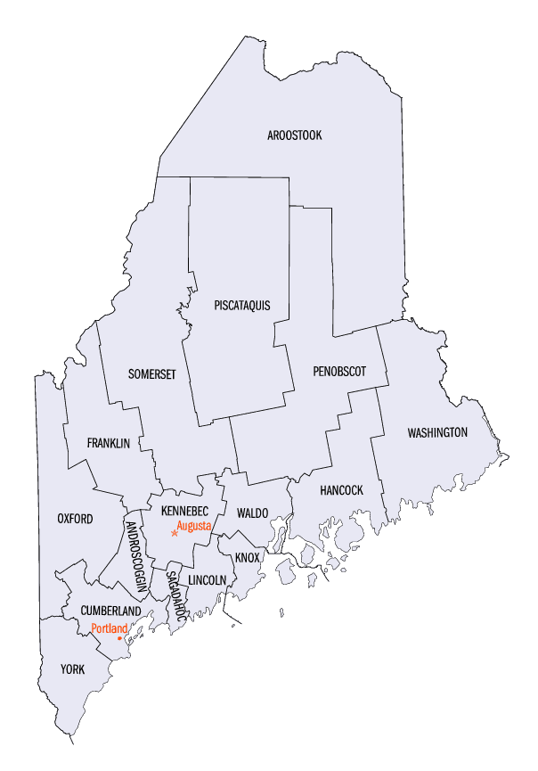
Maine Counties
There are sixteen Counties in Maine. Prior to statehood. The first county to be created was York County, created as York County, Massachusetts by the government of the Massachusetts Bay Colony in 1652. Maine was granted statehood on March 15, 1820 as part of the Missouri Compromise. Nine of the sixteen Counties had their borders defined while Maine was still part of Massachusetts, and hence are older than the state itself. Even after 1820, the exact location of the northern border of Maine was disputed with Britain, until the question was settled and the northern counties took their final, official form by treaty in 1845.Sagadahoc County, Maine
Sagadahoc County Education, Geography, and History
Sagadahoc County is a county located in the state of Maine. Based on the 2010 census, the population was 35,293. Its county seat is Bath.
In geographic area, it is the smallest county in Maine.
Sagadahoc County is part of the Portland-South Portland, ME Metropolitan Statistical Area.
Etymology - Origin of Sagadahoc County Name
Sagadahoc is named for a Native American word meaning mouth of big river.
Demographics:
County QuickFacts: CensusBureau Quick Facts
History of Sagadahoc County, Maine
From: A Gazetteer of the State of Maine
By Geo. J. Varney
Published by B. B. Russell, 57 Cornhill,
Boston 1886
Sagadahoc County is situated upon the lower portions of the Kennebec and Androscoggin Rivers. Within it are
contained Merrymeeting Bay, where the two rivers join; Sagadahoc River, which they form; and Sasanoa, an arm of the
Sagadahoc. Generally, however, the name Kennebec is applied to this stream quite to the sea, thus making the
Androscoggin its tributary. This county contains ten towns and one city, as follows: city of Bath, towns of Arrowsic,
Bowdoin, Bowdoinhani, Georgetown, Perkins, Phi pshurg, Richmond, Topsham, West Bath and Woolwich. The length of the
county north and south is 33 miles, and its breadth, from 6 to 17 miles. It has an area of about 300 square miles,
including water surface, which is about 45 square miles. The county is chiefly remarkable topographically for the
number of its streams, bays and coves, and its numerous tide-powers. The surface of the county, though considerably
broken, has no high hills, and the general altitude is such that the fresh-water streams and salt inlets are not
productive of deep ravines. In the south-eastern portion of the county especially, the bed rock is imperfectly
covered with soil, and consequently, it shows many ledges. Three of its towns, Arrowsic, Perkins and Georgetown, are
islands, and three, Phipsburg, Bath and West Bath are nearly so. The business is agriculture, ice-storage, lumber
manufacture, ship-building, navigation, commerce and the fisheries. Steamboat communication with Portland and Boston
is had through the whole length of the county, while during the hot months steamers run across the country from the
Kennebec towns to Boothbay beyond the Sheepscot River. The Maine Central Railroad traverses the western part north
and south along the course of the Kennebec, and connects with the Knot and Lincoln Railroad, which connects Bath
with Rockland on the Penobscot.
Sagadahoc County was formerly included in Yorkshire, and later, in Lincoln County; having been set off from the
latter and incorpo rated in 1854. The exploring company of DeMonts, led by the intrepid Champlain made the first
known visit of Europeans to Sagadahoc. Popham's colony, having erected buildings and constructed a vessel, after a
few months' sojourn forsook their settlement in 1608; but voyages of the English to the vicinity for fur-trade and
fishing were continned. Capt. .John Smith, of Virginia fame, explored the region in 1614 ; and on the map of the
country which he displayed to King Charles, that monarch eiiterecl the name "Leethe" as a substitute for
"Sagadahoc."
When the Council of Plymouth was dissolved, and the territory divided, 10,000 acres somewhere on the east side of
the Sagadahoc were added to each of seven of the twelve divisions, that each of the noble owners might share in the
visionary metropolis of New England. The grant to Sir Ferdinatulo Gorges, in 1622, had for its eastern boundary, the
Sagadahoc. From this he granted to Sir Richard Edgecomb, a tract on the north side of the Lake of New Somerset (Merrymeeting
Bay) and another on the coast, probably on New Meadows Harbor. The Pilgrims of New Plymouth received their patent
rights of trade on the Kennebec in 1623, which was enlarged in 1629 to a right to the soil and exclusive rights of
trade within its limits. The boundaries of this grant, like those of most of the early ones, were not accurately
defined; and when the patent passed from its Pilgrim ownership and became the Kennebec Purchase, its wealthy
proprietors extended their claims over the territories of their neighbors beyond what generally found warrant in
law, when the issues came to be tried in the courts. The indefinite boundaries, therefore, were the cause of much
litigation. Rights to the soil were sought from the natives also; the first known being the Nequasset purchase, made
in 1639; the islands below soon after, and within 20 years the whole of Sagadahoc County was held under titles from
its Indian possessors. The grant to Purchase and Way which, together with the Pejepscot Purchase included a large
part of Bowdoinham, and all of Topsham, Bath, West Bath,and Phipsburgh, was made in 1630; Purchase himself having
resided near the Pejepscot (Brunswick) Falls since 1627. In 1654 New Plymouth colony instituted a form of government
covering all the settlements of the Kennebec. This was succeeded by the more effective jurisdiction of
Massachusetts, which continued, with a partial interruption only for a few years by the Duke of York's government,
until Maine became an independent State. In 1672, upon a petition of the settlers for protection, the territory
beyond the Kennebec, which had been erected into the county of Cornwall by the Kings' commissioners,- deputies of the
Duke of York, was transmuted into the county of Devonshire; York being limited to the western side of the Sagadahoc.
An appearance of right to exercise this jurisdiction had been secured by a new interpretation of the terms fixing
the boundary of her patent by Massachusetts. The motive for this movement was found in the new claim of the French,
under the treaty of Breda, to the territory as far west as the Kennebec.
The first Indian war in Maine, called King Philip's war, broke out in 1675; yet the plundering of Mr. Purchas' house
was the only hostile act in Sagadahoc County until August, 1676. At this date occurred the descent of the savages
upon the settlements of Hammond, Clark and Lake, in which 53 persons were made captives by the Indians. The region
was now almost wholly abandoned by settlers; and though various small and temporary settlements were attempted,
there was no permanent occupation until 1715, when twenty families located on Arrowsic, and the Pejepscot town of
Augusta was begun under Dr. Noyes in Phipsburg. Yet these were swept away; and forts and garrison houses were often
the only places of safety for the inhabitants, until the fall of the French power in the North in 1759 terminated
the Indian wars in Maine. From 1717 to 1720 many Scotch-Irish Presbyterians had come in; and after Governor Dummer's
treaties of 1725- 7 the immigrants became numerous.
During the Revolution, there was much alarm in the Sagadahoc region from British cruisers; but no considerable
action occurred. Two British armed vessels which threatened Bath, were attacked on their way up the river, and
turned back. In the war of 1812, the noted action between the Enterprise and Boxer occurred off its southeastern
shore. In the war of the Rebellion the county furnished to the Union forces 2,488 men. Robert Gutch and Ichabod
Wiswall were the first religious ministers in the county, the first coming about 1660.
Steam-power was first used on the Kennebec as early as 1818, for propelling rude craft; and in 1823 steam
communication was opened. between Bath and Boston. What is now the Bath branch of the Maine Central Railroad was
opened to the city in 1849; and the Knox and Lincoln Railroad was opened in 1871. The first newspaper was published
in the county in 1820. There are now but two. Eight national banks and three savings institutions are located in the
county.
Sagadahoc County was set off from Lincoln and incorporated in 1854, Bath being made the shire town. Its valuation in
1870 was $11,041,340. In 1880 it was $10,297,215. The polls in 1870 numbered 4,669, and in 1880, 5,182. The
population in 1870 was 18,803. In 1880 it was 19,276...Sagadahoc
County
Geography: Land and Water
As reported by the Census Bureau, the county has a total area of 370 square miles (959 km2), of
which, 254 square miles (658 km2) of it is land and 116 square miles (301 km2) of it (31.41%) is water.
Neighboring Counties
Bordering counties are as follows:
- Kennebec County, Maine - north
- Lincoln County, Maine - east
- Cumberland County, Maine - west
- Androscoggin County, Maine - northwest
Education


Click Image to Enlarge
