

Click Image to Enlarge
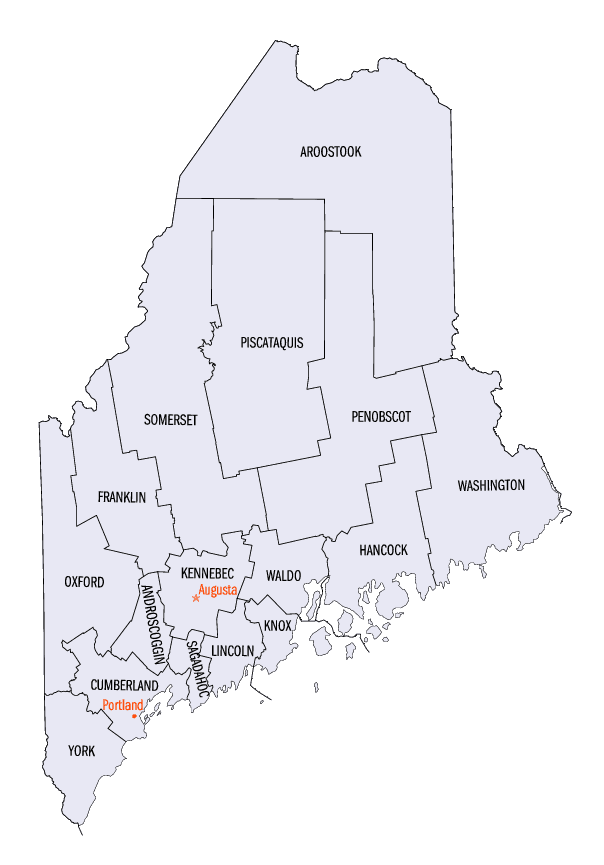
Maine Counties
There are sixteen Counties in Maine. Prior to statehood. The first county to be created was York County, created as York County, Massachusetts by the government of the Massachusetts Bay Colony in 1652. Maine was granted statehood on March 15, 1820 as part of the Missouri Compromise. Nine of the sixteen Counties had their borders defined while Maine was still part of Massachusetts, and hence are older than the state itself. Even after 1820, the exact location of the northern border of Maine was disputed with Britain, until the question was settled and the northern counties took their final, official form by treaty in 1845.Washington County, Maine
Washington County Education, Geography, and History
Washington County is a county located in the state of Maine. Based on the 2010 census, its population was 32,856, making it the third-least populous county in Maine. Its county seat is Machias. The county was established on June 25, 1789. It borders the Canadian province of New Brunswick.
Etymology - Origin of Washington County Name
Washington is named for George Washington, the first president of the United States.
Demographics:
County QuickFacts: CensusBureau Quick Facts
Washington County History
History of Washington County, Maine
From:
A Gazetteer of the State of Maine
By Geo. J. Varney
Published by B. B. Russell, 57 Cornhill,
Boston 1886
Washington County, as originally constituted, embraced the entire eastern frontier. of Maine. It was established
June 25, 1789, by the same act which formed Hancock County. Its western boundary was the eastern line of Hancock. It
was bounded "south and south-east by the sea or western ocean, on the north by the utmost northern limits of this
commonwealth, and easterly by the river St. Croix." In 1839 it surrendered to Aroostook County established at that
date all the terricory "north of the north line of the fourth range of townships, north of the 'lottery townships.'
The area of the county is about 2,700 square miles. It has about 180 miles of sea-coast, abounding in bays and
inlets which afford excellent harbors. The principal rivers are the St. Croix and its west branch, the Scitoodic,
Denny's, East and West Machias, Pleasant and the Narraguagus. Of its numerous lakes, the largest are the Schoodic
series, Baskahegan, Meddybemps and Gardner's. The surface is gradually undulating or varied by swells of no great
height, and the soil back from the seashore is usually fertile. Probably the first European visitor of Maine was
Capt. John Rut and his crew of the English vessel called "The Mary of Guilford," in 1527, when he reconnoitred along
our shores, sailing westerly from Liverpool, N.S. The next of whose landingplace we have definite knowledge was
DeMonts, in 1603, who erected a fort and buildings and passed the succeeding winter on an island at the mouth of the
St. Croix River. This is now known as Neutral Island. By him it was named St. Croix; and from this, probably, the
river has acquired its name. His company was composed of Roman Catholics and Huguenots, or French Protestants, in
about equal numbers; himself belonging to the first, as well as his chaplain. Here was preached the first European
sermon in New England. "There is no authentic record," says the historian of Washington County,* "of a settlement by
whites on Machias River prior to - June, 1763. Richard Vines, however, set up a trading-house on the west side of
Machias River, near Clark's Point, now Machiasport, in 1632 or 1633, leaving it in charge of five men. In less than
one month, La. Tour, a French explorer, deputy and proprietor in Nova Scotia, seized the whole stock of Vines'
trading-house, made prisoners of the men and sent the whole to France. The French planted a few habitations here in
1644, but were unsuccessful; and a similar attempt in 1674 also resulted in failure. In 1748 Richard Hazen was
employed by the Governor of Massachusetts to make surveys and form a chart and plan of the coast. About 1753
Florentius Vassal, a resident of the island of Jamaica, proposed that Massachusetts should transfer the territory
between St. Croix and Penobscot to him and his associates, on certain conditions of settlement. The legislative
branches of the government assured him that if he would, within five years, obtain his Majesty's approbation,
introduce 5,000 settlers, a proportionate number of Protestant clergyman, and satisfy Indian claims, the emigrants
should have all the lands they would settle, and all the islands within 3 miles of the coast. In 1760 a similar
proposition was made to Massachusetts h the Earl of Castlereagh and Francis Vassal in regard to lands upon Machias
River, but nothing was done. About this time the King authorized the General Court of Massachusetts to make free
grants of land to those officers and privates who had served in the French and Inlian wars, just terminated. A
captain was to receive 3,000, a subaltern 2,000, and a private 500 acres.
After the downfall of the French power in the north, in 1760, the Indians manifested a disposition to maintain peace
and amity with the settlers, and to the present time this friendship has not been interrupted.
The rivers of this county are noted for their falls, and their ample lake reservoirs, forming abundant water-power.
They were heavily timbered to their sources, and their extensive areas have been diked and reclaimed from the waters
and made valuable hay producing lands. The bottom lands are rich, and there are many large tracts of fine arable
soil, which are bearing heavy crops of corn, wheat, hay and potatoes. The rivers are prolific in pickerel, trout,
togue, perch, and salmon. The sea fisheries are extensive and profitable, employing a large capital and great
numbers of men and boys. The granite business is receiving increased attention, and excellent quarries are being
wrought at Addison, Jonesborough, Marshfield, and Red Beach in Calais.
Machias, the shire-town of this county from its inauguration, is also the oldest town. By an act of Congress in
1789, all the coasts and ports of Maine were classed in nine commercial districts, in each of which a collector and
other customs officers were appointed by President Washington. Machias was made a port of entry, Stephen Smith being
appointed first collector. From the earliest settlement of the county its people have been largely engaged in
building vessels, mostly of a small size, suitable for coasting and fisheries. In 1873, 9,482 tons of shipping were
built in the Machias district. In 1856, 17 vessels, ranging from 100 to 1000 tons each were built at Robbinston.
Pembroke, Calais, East Machias, Lubec, Millbridge, Columbia Falls and Addison are ship-building towns...Washington
County
Geography: Land and Water
As reported by the Census Bureau, the county has a total area of 3,255 square miles (8,430 km2), of which,
2,568 square miles (6,652 km2) of it is land and 686 square miles (1,778 km2) of it (21.09%) is water.
Neighboring Counties
Bordering counties are as follows:
- Hancock County, Maine - southwest
- Aroostook County, Maine - northwest
- Penobscot County, Maine - northwest
- York County, New Brunswick, Canada - northeast
- Charlotte County, New Brunswick, Canada - east
Education


Click Image to Enlarge
