


Click Image to Enlarge
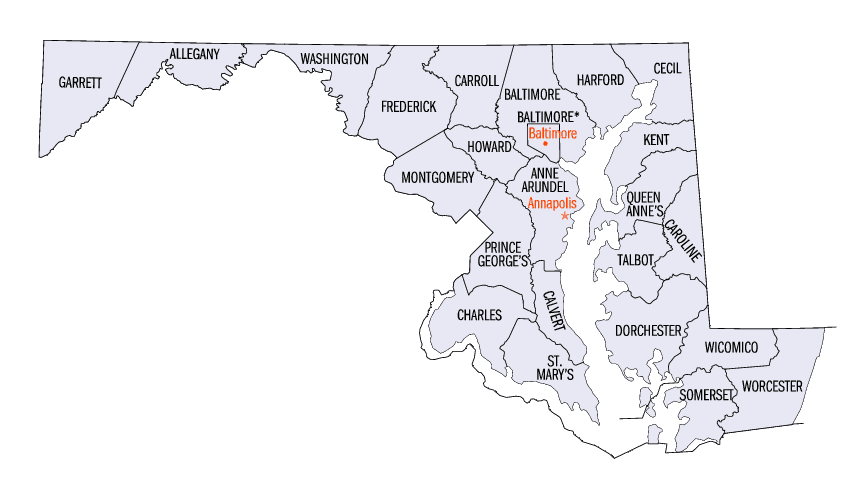
Maryland Counties
There are twenty-four counties and county-equivalents in Maryland. Though an independent city rather than a county, the City of Baltimore is considered the equal of a county. The last new county formation in Maryland occurred when Garrett County was formed in 1872 from portions of Allegany County.Wicomico County, Maryland
Wicomico County Education, Geography, and History
Wicomico County is a county located in the southeastern part of the state of Maryland. Based on the 2010 census, the population was
98,733. The county seat is Salisbury.
Wicomico County is included in the Salisbury, MD-DE Metropolitan Statistical Area.
Etymology - Origin of Wicomico County Name
The county was named for the Wicomico River, which in turn derives from Algonquian language words wicko mekee, meaning "a place where houses are built," apparently referring to an Indian town on the banks.
Demographics:
County QuickFacts: CensusBureau Quick Facts
Wicomico County History
Wicomico County was created from Somerset and Worcester counties in 1867 (Constitution, Art. XIII, secs. 2-6).
Wicomico was part of "Old Somerset", which once encompassed the entire lower Eastern Shore area of Maryland and was settled as early as the 1660s. The original boundaries of Somerset County, shown in green, were split in 1742, when Worcester County was formed, and again in 1867 with the formation of Wicomico County from parts of Somerset and Worcester. By 1750, the dispute over the southern boundary of Delaware was finally over, and Lord Baltimore lost the Sussex County area to William Penn. Another close neighbor is Dorchester County, Maryland.
Geography: Land and Water
As reported by the Census Bureau, the county has a total area of 400 square miles (1,000 km2), of which 374 square miles (970 km2) is
land and 26 square miles (67 km2) (6.4%) is water.
The county's boundary with Delaware is composed of the Mason-Dixon line and the Transpeninsular Line. The intersection of these two historical
lines is the midpoint of the Transpeninsular Line, fixed by Mason and Dixon between 1763 and 1767. The midpoint is located about 8 miles (13
km) northwest of Salisbury, near the center of the Delmarva Peninsula. The county is generally flat, characteristic of the region, with a few
small hills in the northeast. The lowest elevation is at sea level and the highest elevation is 98 ft (30 m).
Neighboring Counties
Bordering counties are as follows:
- North: Sussex County, Del.
- Southeast: Worcester County
- South: Somerset County
- Southwest: Chesapeake Bay
- West: Dorchester County
Education
Primary and secondary schools
Wicomico County Public Schools operates public schools in the county.
Colleges and universities
Salisbury University
Sojourner-Douglass College
Wor-Wic Community College


Click Image to Enlarge
