

Click Image to Enlarge
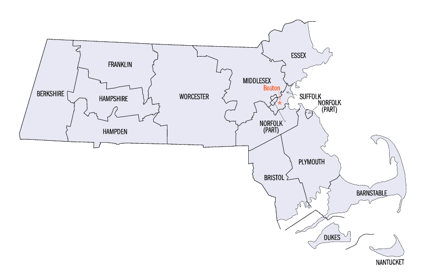
Massachusetts Counties
Massachusetts consists of the fourteen counties. Massachusetts has abolished seven of its fourteen county governments, leaving five Counties with county-level local government (Barnstable, Bristol, Dukes, Norfolk, Plymouth) and two, Nantucket County and Suffolk County, with combined county/city government. The oldest counties still in Massachusetts are Essex County, Middlesex County, and Suffolk County, created in 1643 with the original Norfolk County which was absorbed by New Hampshire and bears no relation to the modern Norfolk County.Barnstable County, Massachusetts
Barnstable County Education, Geography, and History
Barnstable County is a county located in the state of Massachusetts. Based on the 2010 census, the population was 215,888. Its county
seat is Barnstable. The county consists of Cape Cod and associated islands. (Some adjacent islands are in Dukes County and Nantucket County.)
Barnstable County comprises the Barnstable Town, MA Metropolitan Statistical Area, which is also included in the Boston-Worcester-Providence,
MA-RI-NH-CT Combined Statistical Area.
Etymology - Origin of Barnstable County Name
After its county seat of Barnstable, which is named after the English town of Barnstaple
Demographics:
County QuickFacts: CensusBureau Quick Facts
Barnstable County History
Barnstable County was formed as part of the Plymouth Colony on 2 June 1685, including the towns of Falmouth, Sandwich and others lying to the east and north on Cape Cod. Plymouth Colony was merged into the Province of Massachusetts Bay in 1691.
Established as a County in the year 1685, the current boundary lines were drawn in 1707 and have not changed since
that date. Although initially the counties of the Commonwealth were mainly judicial in nature, over time additional
responsibilities were assigned by the state legislature. Subsequently, many counties served as subdivisions of the state
government, serving as an administrative arm of the Commonwealth on a regional basis, but without legislative authority.
This changed in Barnstable County with the passage of the Barnstable County Home Rule Charter, signed into legislation
in July of 1988, which guaranteed certain rights of home rule for the county and established a legislative body with the
power to enact ordinances. This increased Barnstable County's accountability to the residents of Cape Cod and provided
for increased citizen participation and input in the function of County Government.
The County seat is located in Barnstable Village on Historic Route 6A, the Old King's Highway, in the Town of
Barnstable.
Geography: Land and Water
As reported by the Census Bureau, the county has a total area of 1,306 square miles (3,382 km2), of which, 396 square miles (1,024 km2) of it is land and 910 square miles (2,357 km2) of it (69.71%) is water.
Barnstable County consists of the 15 coastal towns located on the peninsula known as Cape Cod. Bordered on the north by Cape Cod Bay, to the east by the Atlantic Ocean and to the south by Nantucket Sound, it is the easternmost point of land in the Commonwealth of Massachusetts. With over 550 miles of shoreline and more than 360 lakes and ponds, the maritime heritage of the region is deeply rooted.
Neighboring Counties
Bordering counties are as follows:
- North: Cape Cod Bay
- East: North Atlantic Ocean
- South: Nantucket Sound
- Southwest: Dukes County; Buzzards Bay
- Northwest: Plymouth County
Education


Click Image to Enlarge
