

Click Image to Enlarge
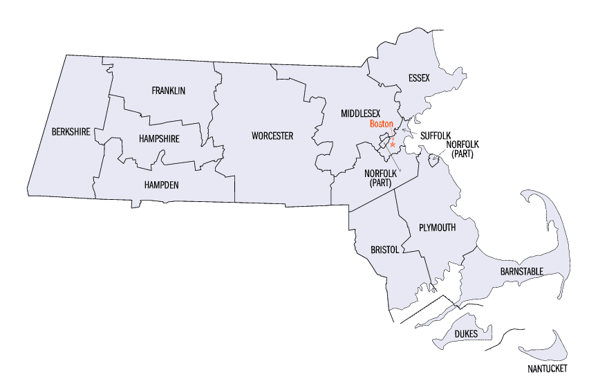
Massachusetts Counties
Massachusetts consists of the fourteen counties. Massachusetts has abolished seven of its fourteen county governments, leaving five Counties with county-level local government (Barnstable, Bristol, Dukes, Norfolk, Plymouth) and two, Nantucket County and Suffolk County, with combined county/city government. The oldest counties still in Massachusetts are Essex County, Middlesex County, and Suffolk County, created in 1643 with the original Norfolk County which was absorbed by New Hampshire and bears no relation to the modern Norfolk County.Bristol County, Massachusetts
Bristol County Education, Geography, and History
Bristol County is a county located in the Commonwealth of Massachusetts. Bristol County was created by the Plymouth Colony on June 2, 1685,
and named after its "shire town" (county seat), Bristol. The Plymouth Colony merged into the Massachusetts Bay Colony in 1691. Based on the 2010 census, the population was 548,285. The county seat
is Taunton. Some governmental functions are performed by the Commonwealth of Massachusetts, others by the county, and others by local towns
and cities. See Administrative divisions of Massachusetts. The property deed records are kept in Taunton, Attleboro, Fall River, and New
Bedford.
Bristol County is included in the Providence-Warwick, RI-MA Metropolitan Statistical Area, which is also included in the
Boston-Worcester-Providence, MA-RI-NH-CT Combined Statistical Area. The county is adjacent to the state of Rhode Island.
Etymology - Origin of Bristol County Name
For its original county seat of Bristol, Massachusetts, which is named for the English port city of Bristol - when the city of Bristol joined Rhode Island, the name of the county was kept
Demographics:
County QuickFacts: CensusBureau Quick Facts
Bristol County History
Bristol County was formed on 2 June 1685 when Old Plymouth Colony was divided into three counties, Plymouth, Bristol
and Barnstable. Barnstable and Plymouth counties were named after their county seats. Bristol County, MA county seat is
Taunton. Native Americans played a very important role before and during the "settlement" of the area.
Bristol County is a county located in the Commonwealth of Massachusetts, adjacent to the state of Rhode Island. The land
that is now Bristol County was part of the Plymouth Colony, which pre-dates the Massachusetts Bay Colony. Part of the
county's land has been transferred to Rhode Island over time
Geography: Land and Water
As reported by the Census Bureau, the county has a total area of 691 square miles (1,790 km2), of which, 556
square miles (1,440 km2) of it is land and 135 square miles (350 km2) of it (19.56%) is water. The highest point in
Bristol County is Sunrise Hill (Watery Hill) at 390 feet above sea level located in World War I Memorial Park in
North Attleborough.
Neighboring Counties
Bordering counties are as follows:
- North: Norfolk County
- Northeast: Plymouth County
- Southeast: Buzzards Bay
- Southwest: Newport County, R.I.; Bristol County, R.I.
- West: Providence County, R.I.
Education


Click Image to Enlarge
