

Click Image to Enlarge
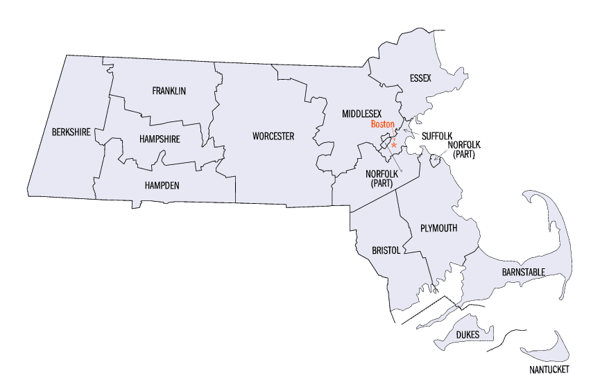
Massachusetts Counties
Massachusetts consists of the fourteen counties. Massachusetts has abolished seven of its fourteen county governments, leaving five Counties with county-level local government (Barnstable, Bristol, Dukes, Norfolk, Plymouth) and two, Nantucket County and Suffolk County, with combined county/city government. The oldest counties still in Massachusetts are Essex County, Middlesex County, and Suffolk County, created in 1643 with the original Norfolk County which was absorbed by New Hampshire and bears no relation to the modern Norfolk County.Hampshire County, Massachusetts
Hampshire County Education, Geography, and History
Hampshire County is a non-governmental county located in the state of Massachusetts. Based on the 2010 census, the population was
158,080. Its most populous municipality is Amherst, and its county seat is Northampton. The county is named after the county Hampshire, in
England.
Hampshire County is part of the Springfield, MA Metropolitan Statistical Area.
Etymology - Origin of Hampshire County Name
For the English county of Hampshire
Demographics:
County QuickFacts: CensusBureau Quick Facts
Hampshire County History
Hampshire County is a non-governmental county located in the state of Massachusetts.
Hampshire County was formed in 1662 out of Middlesex County, an original county of the Massachusetts Bay Colony which organized counties in 1643. Like a number of Massachusetts counties, Hampshire County exists today only as a historical geographic region and a judicial district and has no county government.
- 7 May 1662 This county was formed around the settlements of Springfield, Northampton, and Hadley. The boundary was the southern line of Massachusetts Bay Colony and thirty (30) miles from these three towns so that its effectively became the entire western half of the Colony. [Mass. Recs., 4: 2: 52]
- 19 May 1669 The inhabitant of Woronoake belonging to Springfield petitioned and were granted the creation of a new town called Westfield (which then included Southwick) including land below the south line of the Colony that later was the source of a border dispute. [Mass. Recs., 4: 2: 432]
- 3 June 1674 The granting of the six-square-mile town of Suffield (being an abbreviation for Southfield) whose northern border is the south border of Springfield. The grant read "it being the southernmost toune that either at present is or like to be in that country, & neere adjoyning to the south border of our patent in those parts." [Mass. Recs., 5: 12-13]
- 16 May 1683 The granting of the town of Enfield starting at the mouth of the Longmeadow Brook (about one mile north of the present state line), for six miles south along the Connecticut River eastward from this river ten miles.
- 10 July 1731 Worcester. [Mass. Col. Acts, Vol. 2, Ch. 8 [1730/1], Sec. 1, p. 584]
- 16 Jan. 1741/2 Loss when part of Brimfield was combined with parts of Brookfield and Kingsfield to set of the new town
of Western (now Warren). [Mass. Col. Acts, Vol. 2, Ch. 17 [1741/2], Sec. 2, p. 1088]
- May 1749 Large loss when Enfield and Somers (formerly the eastern part of Enfield) petitioned Connecticut to be annexed which was granted. - 12 Apr. 1753 Hampshire County boundaries redefined to include all territory west of the Connecticut River. [Mass. Col. Acts, vol. 3, Ch. 27 [1752/3], p. 656]
- 9 June 1756 Border adjusted between Greenwich (now extinct) and Hardwick, Worcester Co., that resulted in no discernible change. [Mass. Col. Acts, vol. 15, ch. 51 [1756/7], p. 550]
- 30 June 1761 Large loss as western third of the county was set off to establish Berkshire county. [Mass. Col. Acts, vol. 4, Ch. 33 [1760/1], Sec. 1, p. 432]
- 5 Jan. 1764 Small loss when part of Palmer annexed to Western (now Warren), Worcester Co. [Mass. Col. Acts, Vol. 17, ch. 14 [1764/5], p. 516]
- 5 Feb. 1765 Small gain when Greenwich (now extinct) annexed part of Hardwick, Worcester Co. [Mass. Col. Acts, Vol. 17, ch. 218 [1764/5], p. 603]
- 30 June 1768 Gain when the town of Worthington was created in Hampshire Co. from Plantation #3 in Berkshire Co. [Mass. Col. Acts, Vol. 4, Ch. 16 [1768], Sec. 1, p. 1028]
- 1774 Loss when Connecticut unilaterally took over the southern part of what would become Southwick in 1775 that was south of the 1713 Provincial boundary.
- 23 June 1779 Cummington was created in Hampshire Co. from Plantation #5 in Berkshire Co. [Mass. Col. Acts, Vol. 5, Ch. 6 [1779/80], Sec. 1, p. 1072-1073]
- 12 Mar. 1783 Gained when parts of Chester, Prescott's Grant, and Worthington along with parts of Becket, Partridgefield (now Peru), and Washington, Berkshire Co., were included in the new town of Middlefield [Mass. Acts, 1783, Ch. 19, Sec. 1, p. 228]
- 15 Oct. 1783 Gain when parts of Athol and Royalston in Worcester Co. were combined to create the new town of Orange. [Mass. Acts, 1783, Ch. 2, Sec. 1, p. 38]
- 9 Feb. 1785 Gain when Myrifield Grant and unincorporated county land both in Berkshire Co. were combined to create the new town of Rowe in Hampshire Co. [Mass. Acts, 1785, Ch. 2, Sec. 1, p. 230]
- 9 Mar. 1793 Gain when Hawley annexed part of Plantation #7, Berkshire Co. [Mass. Acts, 1793, Ch. 18, Sec. 1, p. 242]
- 15 July 1794 Small loss when part of Palmer was annexed to Western (now Warren), Worcester Co.
- 18 Feb. 1801 Loss when parts of Greenwich (now extinct) was combined with parts of Hardwick and Petersham in Worcester Co. to create the new town of Dana in Worcester Co. [Mass. Acts, 1801, Ch. 14, Sec. 1, p. 453]
- 1804 Gained back the "Southwick Jog" that Connecticut annexed in 1774 being the portion of the former town grant below the 1713 Provincial boundary.
- 2 Dec. 1811 Large loss when the northern third was set off to create Franklin County. [Mass. Acts, 1811, Ch. 61, p. 467]
- 1 Aug. 1812 Large loss when the northern half was set off to create Hampden County. [Mass. Acts, 1812, Ch. 137, p. 291]
- 28 Jan. 1822 Gained when parts of Pelham and New Salem, Franklin Co., combined to create the new town of Prescott (now extinct). [Mass. Acts, 1822, Ch. 34, Sec. 1, p. 614]
- 8 Feb. 1823 Small gain when Ware annexed part of Western (now Warren), Worcester Co. [Mass. Acts, 1823, Ch. 76, p. 114]
- 2 Feb. 1849 The border between Williamsburg and Whately, Franklin Co. clarified - no change. [Mass. Acts, 1849, Ch. 3, p. 198]
- 25 May 1853 Gain when Norwich (now Huntington) annexed parts of Chester and Blandford, both in Hampden Co. [Mass. Acts, 1853, Ch. 421, Sec. 1, p. 639]
- 9 June 1909 Loss when part of Northampton annexed by Holyoke, Hampden Co. [Mass. Acts, 1909, ch. 480, Sec. 1, p. 498]
- 29 Mar. 1910 Border between Ware and Palmer, Hampden Co., redefined - no change. [Mass. Acts, 1910, Ch. 471, Sec. 1, p. 422]
- 28 Apr. 1938 Loss when Quabbin Reservoir created and "drowned" four towns. Parts of Greenwich and Prescott annexed to Petersham, Worcester Co
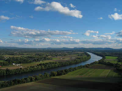
Geography: Land and Water
As reported by the Census Bureau, the county has a total area of 545 square miles (1,413 km2), of which, 529
square miles (1,370 km2) of it is land and 16 square miles (42 km2) of it (3.01%) is water.
Neighboring Counties
Bordering counties are as follows:
- North: Franklin County
- East: Worcester County
- South: Hampden County
- West: Berkshire County
Education
Hampshire County is notable for the presence within its borders of the "Five Colleges", comprising the University of Massachusetts flagship
campus and four well-known private colleges:
Amherst College, Amherst
Hampshire College, Amherst
Mount Holyoke College, South Hadley
Smith College, Northampton
University of Massachusetts Amherst
A consortium, Five Colleges, Inc., provides easy course cross-registration and free bus service between the campuses.


Click Image to Enlarge
