

Click Image to Enlarge
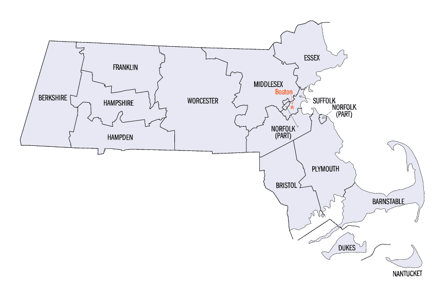
Massachusetts Counties
Massachusetts consists of the fourteen counties. Massachusetts has abolished seven of its fourteen county governments, leaving five Counties with county-level local government (Barnstable, Bristol, Dukes, Norfolk, Plymouth) and two, Nantucket County and Suffolk County, with combined county/city government. The oldest counties still in Massachusetts are Essex County, Middlesex County, and Suffolk County, created in 1643 with the original Norfolk County which was absorbed by New Hampshire and bears no relation to the modern Norfolk County.Plymouth County, Massachusetts
Plymouth County Education, Geography, and History
Plymouth County is a county located in the state of Massachusetts. Based on the 2010 census, the population was 494,919. Its county seats
are Plymouth and Brockton. In 1685 the County was created by the Plymouth General Court, the legislature of Plymouth Colony, predating its
annexation by the Massachusetts Bay Colony.
Plymouth County is included in the Boston-Cambridge-Newton, MA-NH Metropolitan Statistical Area.
Etymology - Origin of Plymouth County Name
For its seat of Plymouth, which is named for the English port city of Plymouth
Demographics:
County QuickFacts: CensusBureau Quick Facts
Plymouth County History
Plymouth County, established 1685 from Massachusetts Bay Colony.
- 2 June 1685 Plymouth County created as one of the three original counties formed out of New Plymouth Colony. [Ply. Laws, ch. 6, p. 19]
- 7 Oct. 1691 Plymouth County became part of the new Massachusetts Bay Colony when its new charter absorbed New Plymouth Colony with no border changes. [Mass. Col. Acts, v. 1, ch. 27 [1692-1693], sec. 1, p. 63]
- 19 Nov. 1707 Plymouth County added the town of Rochester from Barnstable County. [Mass. Col. Acts, v. 21, ch. 60 [1707], p. 755]
- 29 Oct. 1708 Plymouth County added a small non-county area lying between Bristol and Plymouth counties. [Mass. Col. Act,
18 Mar. 1711/2 The "Old Colony Line" that formerly divided Massachusetts Bay and New Plymouth colonies was declared as the border between Suffolk, Bristol, and Plymouth counties with no changes. [Mass. Col. Acts, v. 21, ch. 152 [1711], p. 799] - 20 Nov. 1770 When Bridgewater annexed land from Stoughton, that area moved from Suffolk to Plymouth County. [Mass. Col. Acts, v. 5, ch. 15 [1770-1771], sec. 1, p. 116]
- 8 Feb. 1798 When Bridgewater annexed a strip of land from Stoughton, that area moved from Suffolk to Plymouth County. [Mass. Acts 1798, ch. 10, sec. 1, p. 164]
- 18 June 1803 Plymouth County added the towns of Hingham and Hull from Suffolk County. [Mass. Acts 1803, ch. 14, sec. 1,
p. 246]
14 June 1823 When Cohasset annexed land from Scituate, that area moved from Plymouth to Norfolk County. [Mass. Acts 1823, ch. 28, p. 237] - 9 Apr. 1836 When Rochester and Fairhaven redefined their border, that also redefined the line between Plymouth and Bristol counties. [Mass. Acts 1836, ch. 193, sec. 1, p. 876]
- 20 Mar. 1840 When Scituate annexed land from Cohasset, that area moved from Norfolk to Plymouth County. [Mass. Acts 1840, ch. 58, sec. 1, p. 206]
- 31 Mar. 1847 When Abington and Weymouth redefined their border, that also redefined the line between Plymouth and Norfolk counties. [Mass. Acts 1847, ch. 138, p. 391]
- 1 June 1867 When Taunton and Lakeville redefined their border, that also redefined the line between Plymouth and Bristol counties. [Mass. Acts 1867, ch. 352, sec. 1, p. 745]
- 14 Apr. 1897 When Wareham and Bourne redefined their border, that also redefined the line between Plymouth and Barnstable counties. [Mass. Acts 1897, ch. 281, sec. 1, p. 258]
- 30 Apr. 1897 When Hingham and Cohasset redefined their border, that also redefined the line between Plymouth and Norfolk counties. [Mass. Acts 1897, ch. 330, sec. 1, p. 318]
- 23 Mar. 1928 When Hingham and Cohasset redefined their border, that also redefined the line between Plymouth and Norfolk counties. [Mass. Acts 1928
Geography: Land and Water
As reported by the Census Bureau, the county has a total area of 1,093 square miles (2,832 km2), of which, 661
square miles (1,712 km2) of it is land and 433 square miles (1,120 km2) of it (39.56%) is water.
Neighboring Counties
Bordering counties are as follows:
- Northeast: North Atlantic Ocean
- East: Cape Cod Bay
- Southeast: Barnstable County
- South: Buzzards Bay
- Southwest: Bristol County
- Northwest: Norfolk County
Education


Click Image to Enlarge
