

Click Image to Enlarge
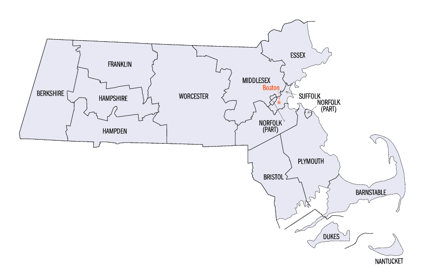
Massachusetts Counties
Massachusetts consists of the fourteen counties. Massachusetts has abolished seven of its fourteen county governments, leaving five Counties with county-level local government (Barnstable, Bristol, Dukes, Norfolk, Plymouth) and two, Nantucket County and Suffolk County, with combined county/city government. The oldest counties still in Massachusetts are Essex County, Middlesex County, and Suffolk County, created in 1643 with the original Norfolk County which was absorbed by New Hampshire and bears no relation to the modern Norfolk County.Worcester County, Massachusetts
Worcester County Education, Geography, and History
Worcester County is a county located in the state of Massachusetts. Based on the 2010 census, the population was 798,552, making it the
second-most populous county in Massachusetts. The largest city and traditional county seat is the city of Worcester.
Worcester County is included in the Worcester, MA-CT Metropolitan Statistical Area as well as the Boston-Worcester-Providence, MA-RI-NH-CT Combined
Statistical Area.
Etymology - Origin of Worcester County Name
For its county seat of Worcester, which is named in honor of the English town of Worcester and the English Civil War Battle of Worcester in 1651, a Parliamentarian victory
Demographics:
County QuickFacts: CensusBureau Quick Facts
Worcester County History
Worcester County was established on April 2, 1731, Worcester was chosen as its shire town (later known as a
county seat). From that date until the dissolution of the county government, it was the only county seat. Because of
the size of the county, there were fifteen attempts over 140 years to split the county into two counties, but
without success. Initially, Lancaster was proposed as the seat of the northern county; later, Petersham was proposed
once and Fitchburg was proposed repeatedly, most recently in 1903. Perhaps as a concession, in August 1884, the
Worcester County Registry of Deeds was split into two, with the Worcester Northern registry placed in Fitchburg.
Worcester County exists today only as a historical geographic region. It has had no county government since July 1, 1998, when all former county functions were assumed by other governmental agencies
Geography: Land and Water
As reported by the Census Bureau, the county has a total area of 1,579 square miles (4,090 km2), of which,
1,513 square miles (3,919 km2) of it is land and 66 square miles (171 km2) of it (4.18%) is water. The county
constitutes Central Massachusetts, separating Western Massachusetts on one side from Eastern Massachusetts and the
Greater Boston area on the other side. It stretches from the northern to the southern border of the state. The
geographic center of Massachusetts is in Rutland.
Neighboring Counties
Bordering counties are as follows:
- Northeast: Hillsborough County, N.H.; Middlesex County
- Southeast: Norfolk County; Providence County, R.I.
- South: Windham County, Conn.
- Southwest: Tolland County, Conn.; Hampden County
- West: Hampshire County
- Northwest: Franklin County; Cheshire County, N.H.
Education


Click Image to Enlarge
