


Click Image to Enlarge
Michigan Counties
The boundaries of the eighty-three counties in Michigan have not changed substantially since 1897. Wayne County was the sixth county in the Northwest Territory, formed 15 August 1796 and organized in 1815. Wayne County was created 21 November 1815 as an original county of Michigan.Gratiot County, Michigan
Gratiot County Education, Geography, and History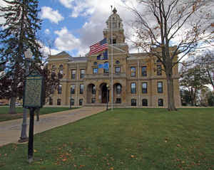
Gratiot County is a county located in the state of Michigan. Based on the 2010 census, the population was 42,476. The county seat is
Ithaca, although its most populous city is Alma.
Gratiot County comprises the Alma, MI Micropolitan Statistical Area, which is also included in the Mount Pleasant-Alma, MI Combined
Statistical Area.
Etymology - Origin of Gratiot County Name
Gratiot County is named for Charles Gratiot, the military officer who built Fort Gratiot at the present site of Port Huron.
Demographics:
County QuickFacts: CensusBureau Quick Facts
Gratiot County History
Gratiot County is named for Charles Gratiot, the military officer who built Fort Gratiot at the present site of Port Huron.
Set Off: 1831
Organized: 1855
The county is named for Captain Charles Gratiot, who supervised the building of Port Huron's Fort Gratiot. It was set off in 1831; organized in 1855. Gratiot County was a New England settlement. The original founders of Ithaca and of Alma consisted entirely of settlers from New England. These people were "Yankee's", that is to say they were descended from the English Puritans who settled New England in the 1600s. They were part of a wave of New England farmers who headed west into what was then the wilds of the Northwest Territory during the early 1800s. Most of them arrived as a result of the completion of the Erie Canal as well as the close of the Black Hawk War. When they arrived in what is now Gratiot County there was nothing but a virgin forest and wild prairie, the New Englanders laid out farms, constructed roads, erected government buildings and established post routes. They brought with them many of their Yankee New England values, such as a passion for education, establishing many schools as well as staunch support for abolitionism.
Geography: Land and Water
As reported by the Census Bureau, the county has a total area of 572 square miles (1,480 km2), of which 568 square miles (1,470 km2) is land and 3.1 square miles (8.0 km2) (0.6%) is water. It is considered to be part of Central Michigan.
Neighboring Counties
Bordering counties are as follows:
- Midland County (northeast)
- Isabella County (northwest)
- Saginaw County (east)
- Montcalm County (west)
- Shiawassee County (southeast)
- Clinton County (south)
- Ionia County (southwest)
Education


Click Image to Enlarge
