


Click Image to Enlarge
Michigan Counties
The boundaries of the eighty-three counties in Michigan have not changed substantially since 1897. Wayne County was the sixth county in the Northwest Territory, formed 15 August 1796 and organized in 1815. Wayne County was created 21 November 1815 as an original county of Michigan.Ionia County, Michigan
Ionia County Education, Geography, and History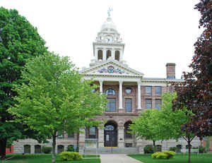
Ionia County is a county located in the state of Michigan. Based on the 2010 census, the population was 63,905. The county seat is Ionia.
The Ionia County Courthouse was built by Claire Allen, a prominent southern Michigan architect.
Ionia County comprises the Ionia, MI Micropolitan Statistical Area, which is also included in the Grand Rapids-Wyoming-Muskegon, MI Combined
Statistical Area.
Etymology - Origin of Ionia County Name
Ionia County is named for the ancient Greek region Ionia.
Demographics:
County QuickFacts: CensusBureau Quick Facts
Ionia County History
Ionia County is named for the ancient Greek region Ionia.
Set Off: 1831
Organized: 1837
Geography: Land and Water
As reported by the Census Bureau, the county has a total area of 580 square miles (1,500 km2), of which 571 square miles (1,480 km2) is land and 8.7 square miles (23 km2) (1.5%) is water.
Neighboring Counties
Bordering counties are as follows:
- Gratiot County (northeast)
- Montcalm County (north)
- Clinton County (east)
- Kent County (west)
- Eaton County (southeast)
- Barry County (southwest)
Education


Click Image to Enlarge
