


Click Image to Enlarge
Minnesota Counties
There are eighty-seven Counties in Minnesota. On October 27, 1849 nine large Minnesota Counties were created. Among them were Benton, Dahkotah, Itasca, Ramsey, Mahkahta, Pembina, Wabashaw, Washington, and Wahnata. Of those Benton, Dakota, Itasca, Ramsey, Wabasha, and Washington still exist as their original name. With the creation of Kittson County on March 9, 1878, Pembina County no longer existed. When Minnesota was organized as a state, 57 of the present 87 Counties were established. The last county to be created was Lake of the Woods County in 1923Cottonwood County, Minnesota
Cottonwood County Education, Geography, and History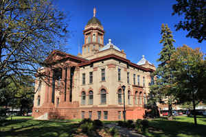
Cottonwood County is a county located in the state of Minnesota. Based on the 2010 census, the population was 11,687. Its county seat is Windom. The county was formed in 1857 and organized in 1870.
Etymology - Origin of County Name
Named after the Cottonwood River. Cottonwood is a translation of Waraju, the Dakota name for the river, reflecting the abundance of the tree on its banks.
Demographics:
County QuickFacts: CensusBureau Quick Facts
Cottonwood County History
Cottonwood County was established July 29, 1870. It was named after the Cottonwood River which runs through the
northeast corner of Germantown Township. The river received its name from the abundance of cottonwood trees on its banks.
Minnesota Governor Austin appointed three county commissioners when the county was established. They met at a private home about six miles
northwest of Windom on the Des Moines River at Big Bend. During this meeting, they designated the commissioners districts and changed various
county officers. In the fall of 1870, the first general election was held. The first deed on record was filed on January 10, 1870. The first
land assessments were made in 1871, and in 1872, the first taxes were paid.
Windom was declared the county seat in the 1872 general election and a proclamation was signed by the governor.
Geography: Land and Water
As reported by the Census Bureau, the county has a total area of 649 square miles (1,680 km2), of which 639 square miles (1,660 km2) is land and 10 square miles (26 km2) (1.5%) is water.
Neighboring Counties
Bordering counties are as follows:
- Redwood County (north)
- Brown County (northeast)
- Watonwan County (east)
- Martin County (southeast)
- Jackson County (south)
- Nobles County (southwest)
- Murray County (west)
Education


Click Image to Enlarge
