


Click Image to Enlarge
Minnesota Counties
There are eighty-seven Counties in Minnesota. On October 27, 1849 nine large Minnesota Counties were created. Among them were Benton, Dahkotah, Itasca, Ramsey, Mahkahta, Pembina, Wabashaw, Washington, and Wahnata. Of those Benton, Dakota, Itasca, Ramsey, Wabasha, and Washington still exist as their original name. With the creation of Kittson County on March 9, 1878, Pembina County no longer existed. When Minnesota was organized as a state, 57 of the present 87 Counties were established. The last county to be created was Lake of the Woods County in 1923Le Sueur County, Minnesota
Le Sueur County Education, Geography, and History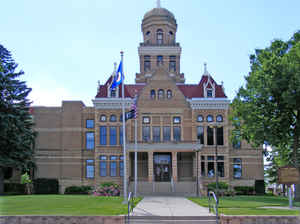
Le Sueur County is a county located in the state of Minnesota. Based on the 2010 census, the population was 2,703. Its county seat is Le
Center. The county is named for the French explorer Pierre-Charles Le Sueur who visited the area in 1700.
Le Sueur County is included in the Minneapolis-St. Paul-Bloomington, MN-WI Metropolitan Statistical Area
Etymology - Origin of Le Sueur County Name
Named for Pierre Charles LeSueur, French-Canadian trader and explorer who traveled sections of the Mississippi River starting in 1683.
Demographics:
County QuickFacts: CensusBureau Quick Facts
Le Sueur County History
Le Sueur County is named after the Great French Explorer, Pierre Charles Le Sueur, who traveled up the St. Peter's River, now known as the
Minnesota River, in the year of 1700. The county seat of Le Sueur County is Le Center. The name Le Center was changed from Le Sueur Center to
Le Center in 1930. The Le Sueur County Courthouse was built in 1896-97 with extensive remodeling taking place in 1974-75 and again in 1994-95.
In 1853, the territorial legislature of Minnesota passed an act establishing a number of counties along the Minnesota River, Le Sueur County
was among them. The earliest settlements in Le Sueur County took place along the river which, as a navigable stream, provided European man
with a highway into this part of the Minnesota Territory.
The first towns established in Le Sueur County or what was to become Le Sueur County, were established, platted and built along the Minnesota
River. They were Le Sueur, Ottawa, and Kasota - Kasota being the earliest.
Le Sueur was the first town of any size and it was designated by the legislature as the county seat. It stands in the northwest corner of the
county and the result was that most of the people living in the county, especially those living inland, had a hard time getting to the county
seat for necessary business, to pay taxes, to serve on juries, to attend court, to register land sales and to trade with the various purveyors
of services.
The roads were terrible. If you lived in the southeastern quarter of the county you had a long and very hard journey to get to the county
seat. Before long a climate of opinion arose to the effect that the county seat should be relocated. At first there was an attempt by the
Cleveland community to acquire it. A referendum was held in Cleveland, in which Cleveland received the largest number of votes, but according
to the court, there were certain informalities in the counting of the ballots and the election was thrown out. The county seat remained in Le
Sueur.
Again Cleveland tried and for a short time in 1875, they held the county seat. The county offices were housed temporarily in an unused church.
The county seat was then returned to Le Sueur.
A number of businessmen, led by L.Z. Rogers of Waterville, undertook to make possible the location of the county seat near the center of the
county by acquiring a tract of 160 acres at what is now Le Center and platted it. They offered the use of a newly constructed two story brick
building to the county board for use as a courthouse if a referendum of the people of the county agreed to allow the moving of the county seat
to this new location, which they chose to call Le Sueur Center. The referendum was held and passed. The county offices were moved to the new
location in 1876 and the county seat has remained there ever since.
Geography: Land and Water
As reported by the Census Bureau, the county has a total area of 474 square miles (1,230 km2), of which 449 square miles (1,160 km2) is land and 25 square miles (65 km2) (5.3%) is water. Le Sueur is one of seven Minnesota savanna region counties where no forest soils exist and one of 17 counties where savanna soils dominate.
Neighboring Counties
Bordering counties are as follows:
- Scott County (north)
- Rice County (east)
- Waseca County (south)
- Blue Earth County (southwest)
- Nicollet County (west)
- Sibley County (northwest)
Education


Click Image to Enlarge
