


Click Image to Enlarge
Minnesota Counties
There are eighty-seven Counties in Minnesota. On October 27, 1849 nine large Minnesota Counties were created. Among them were Benton, Dahkotah, Itasca, Ramsey, Mahkahta, Pembina, Wabashaw, Washington, and Wahnata. Of those Benton, Dakota, Itasca, Ramsey, Wabasha, and Washington still exist as their original name. With the creation of Kittson County on March 9, 1878, Pembina County no longer existed. When Minnesota was organized as a state, 57 of the present 87 Counties were established. The last county to be created was Lake of the Woods County in 1923Nobles County, Minnesota
Nobles County Education, Geography, and History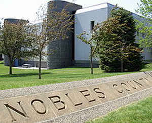
Nobles County is a county located in the state of Minnesota. Based on the 2010 census, the population was 21,378. Its county seat is
Worthington. The county was formed in 1857 and organized in 1870.
Nobles County comprises the Worthington, MN Micropolitan Statistical Area.
Etymology - Origin of Nobles County Name
Named for William H. Nobles, member of the territorial legislature in 1854 and 1856.
Demographics:
County QuickFacts: CensusBureau Quick Facts
Nobles County History
Nobles County was first occupied by the Sisseton Indians. The first white man to set foot on the land was Joseph
Nicolas Nicollet, who came to map out the area in 1842 and named the lakes Okabena (there was also in East Okabena), Ocheyedan and the
Kanaranzi River. The first settlement was near Graham Lakes. Township surveys were run along the Iowa Border in 1852, laying out the Lake and
continued eastward. The territory was organized in 1849. In 1856, there was a great influx of settlers into Minnesota. The panic of 1857
stopped that. During this period only trappers visited Nobles County. Trapping was profitable during the early days. Nobles County was created
by the Minnesota Legislature on May 23, 1857, just before the full force of the panic was felt. Settlers were also discouraged from coming by
the Indian Massacre of 1857. At this time, a band of Sioux has ruthlessly murdered settlers in Spirit Lake and along the Des Moines River in
Jackson and Cottonwood Counties. The few whites in the area were understandably reluctant to stay.
County Government did not start until 1870. The first railroad was built in 1871 from Mankato through Worthington to LeMars, Iowa. This later
became the Chicago, St. Paul, Minneapolis and Omaha. During the summer of 1867, a mail route was established from Blue Earth City through the
Graham Lakes settlement to Yankton, South Dakota. In January, a Post Office was established in each settlement. The population in the spring
of 1870 was 117 and nearly doubled by fall.
In 1871, a group of men from Toledo, Ohio organized a company to locate a colony of settlers in some western county. After traveling 20,000
miles in the Midwest, they decided on Nobles County and by the spring of 1872, hundreds of people came in and took up land. The mail was
brought to Worthington by train and an overland route was established from there to Sioux Falls. Post offices were established in Dewald (one
mile northeast of Rushmore), Adrian and Westside Township. Worthington became the County Seat in 1873. The railroad gave the county a block of
land in the heart of the City of Worthington to be used for a courthouse, which was built in 1877. The building was replaced in 1894 by a
stately building of red brick and massive stone foundation featuring a tower and elaborate cornice work.
Geography: Land and Water
As reported by the Census Bureau, the county has a total area of 723 square miles (1,870 km2), of which 715 square miles (1,850 km2) is land and 7.5 square miles (19 km2) (1.0%) is water
Neighboring Counties
Bordering counties are as follows:
- Murray County (north)
Cottonwood County (northeast)
Jackson County (east)
Osceola County, Iowa (southeast)
Lyon County, Iowa (southwest)
Rock County (west)
Education


Click Image to Enlarge
