


Click Image to Enlarge
Minnesota Counties
There are eighty-seven Counties in Minnesota. On October 27, 1849 nine large Minnesota Counties were created. Among them were Benton, Dahkotah, Itasca, Ramsey, Mahkahta, Pembina, Wabashaw, Washington, and Wahnata. Of those Benton, Dakota, Itasca, Ramsey, Wabasha, and Washington still exist as their original name. With the creation of Kittson County on March 9, 1878, Pembina County no longer existed. When Minnesota was organized as a state, 57 of the present 87 Counties were established. The last county to be created was Lake of the Woods County in 1923Norman County, Minnesota
Norman County Education, Geography, and History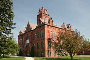
Norman County is a county located in the state of Minnesota. Based on the 2010 census, the population was 6,852. Its county seat is Ada.
The county is located in the Red River Valley region of Minnesota.
Etymology - Origin of Norman County Name
Named to commemorate the great number of immigrants in the county of Norwegian (Norseman or Norman) descent.
Demographics:
County QuickFacts: CensusBureau Quick Facts
Norman County History
Norman County was organized on February 17, 1881, from a part of Polk County, which in turn had been a part of
Pembina County. The name was chosen because of the great number of Norwegian immigrants who settled in the county.
Norman County is located in the Red River Valley of Minnesota, one of the great farming regions of the world. To the east it is bounded by
Mahnomen County, to the south by Clay County, and to the north by Polk County. The western boundary is formed by the Red River of the North
and North Dakota. The county is made up of twenty-four townships. Check out the map of the county as it looked in 1895.Norman County Court
House
The county seat is located in Ada, which is situated near the center of the county.
Geography: Land and Water
As reported by the Census Bureau, the county has a total area of 877 square miles (2,270 km2), of which 873 square miles (2,260 km2) is land and 3.9 square miles (10 km2) (0.4%) is water. Major geographical features include the Red River of the North, which comprises the western border of the county, and the Wild Rice River, which flows from the eastern border to empty into the Red River.
Neighboring Counties
Bordering counties are as follows:
- Polk County (north)
- Mahnomen County (east)
- Becker County (southeast)
- Clay County (south)
- Cass County, North Dakota (southwest)
- Traill County, North Dakota (west)
Education


Click Image to Enlarge
