


Click Image to Enlarge
Minnesota Counties
There are eighty-seven Counties in Minnesota. On October 27, 1849 nine large Minnesota Counties were created. Among them were Benton, Dahkotah, Itasca, Ramsey, Mahkahta, Pembina, Wabashaw, Washington, and Wahnata. Of those Benton, Dakota, Itasca, Ramsey, Wabasha, and Washington still exist as their original name. With the creation of Kittson County on March 9, 1878, Pembina County no longer existed. When Minnesota was organized as a state, 57 of the present 87 Counties were established. The last county to be created was Lake of the Woods County in 1923Red Lake County, Minnesota
Red Lake County Education, Geography, and History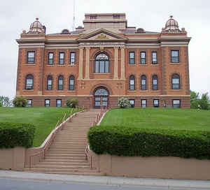
Red Lake County is a county located in the state of Minnesota. Based on the 2010 census, the population was 4,089, making it the
third-least populous county in Minnesota. Its county seat is Red Lake Falls.
It is one of twelve counties in the state of Minnesota that doesn't have a stop light within the county, and is also known as the only
landlocked county in the US that is surrounded by just two neighboring counties.
Etymology - Origin of Red Lake County Name
Named for Red Lake River. Red Lake is the translation of the Ojibway name for this geographic feature, so named because of the color of the lake at sunset.
Demographics:
County QuickFacts: CensusBureau Quick Facts
Red Lake County History
The earliest known settlers in northwestern Minnesota were the Dakota Sioux who were well established by the late 1600's. By 1770 the Chippewa had become the dominant tribe in a wide area of northern and central Minnesota, including the area which later became Red Lake County. In 1863 the Chippewa signed a treaty with the Federal Government which opened up a large tract of land to homesteaders. When Polk County was formed in 1858, it included what would later be both Red Lake and Pennington Counties. On December 24, 1896 Red Lake County was formed from part of Polk County and in 1910 Pennington County was formed from part of Red Lake County. It was named after the Red Lake River.
Geography: Land and Water
As reported by the Census Bureau, the county has a total area of 432 square miles (1,120 km2), of which 432 square miles (1,120 km2) is land and 0.09 square miles (0.23 km2) (0.02%) is water. Despite its name, Red Lake County contains no lakes.
Neighboring Counties
Bordering counties are as follows:
- Pennington County (north)
- Polk County (south)
Education


Click Image to Enlarge
