


Click Image to Enlarge
Mississippi Counties
There are eighty counties in Mississippi. Two original counties were Adams County and Jefferson County (formerly Pickering) established in 1799Claiborne County, Mississippi
Claiborne County Education, Geography, and History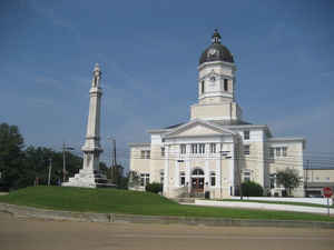
Claiborne County is a county located in the state of Mississippi. Based on the 2010 census, the population was 9,604. Its county seat is
Port Gibson. The county is named after William Claiborne, the second governor of the Mississippi Territory.
Claiborne County is included in the Vicksburg, MS Micropolitan Statistical Area as well as the Jackson-Vicksburg-Brookhaven, MS Combined
Statistical Area. It is bordered by the Mississippi River on the west and the Big Black River on the north.
Etymology - Origin of Claiborne County Name
Claiborne is named for Governor of Mississippi Territory William C. C. Claiborne. William Charles Cole Claiborne (1775 - 23 November 1817) was a United States politician, best known as the first US governor of Louisiana
Demographics:
County QuickFacts: CensusBureau Quick Facts
Claiborne County History
Claiborne County was erected while Mississippi was a Territory and was established January 27, 1802, during the administration of William C.C. Claiborne, Mississippi's second territorial governor. His name is perpetuated in that of the county. The original act of the General Assembly recites that Jefferson County shall be divided as follows:
"Beginning on the river Mississippi at the mouth of Petty Gulph Creek; thence running up the main branch of said creek four miles, or to its source, should not exceed four miles; thence, by a line to be drawn due east, to the eastern territorial line, and all that tract of country, north of the above mentioned creek, an east line, south of the northern boundary of said territory, and east of the Mississippi River, shall compose a county, which shall be called Claiborne."
The act of June 29, 1822, defining the boundaries of the several counties of the State, declared that the dividing line between the counties of Claiborne and Jefferson should be as follows:
"Beginning on the bank of the Mississippi River, at the lower end of the Petit Gulf Hills, running thence a direct course to the most northern part of the tract of land known by the name of Robert Trimble's, on Tabor's Creek of Bayou Pierre, continuing the same course until it shall intersect the South Fork of Bayou Pierre, at Elijah L. Clarke's wagon ford on said creek, thence up said creek to the township line between townships 9 and 10, thence pursuing said line east to the old Choctaw boundary line."
The first civil officers of the county, commissioned January 30, 1802. The County seat is Port Gibson.
Geography: Land and Water
As reported by the Census Bureau, the county has a total area of 501 square miles (1,299 km2), of which, 487
square miles (1,261 km2) of it is land and 15 square miles (38 km2) of it (2.91%) is water.
Neighboring Counties
Bordering counties are as follows:
- Warren County (north)
- Hinds County (northeast)
- Copiah County (southeast)
- Jefferson County (south)
- Tensas Parish, Louisiana (west)
Education


Click Image to Enlarge
