


Click Image to Enlarge
Mississippi Counties
There are eighty counties in Mississippi. Two original counties were Adams County and Jefferson County (formerly Pickering) established in 1799Jackson County, Mississippi
Jackson County Education, Geography, and History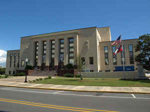
Jackson County, is a county located in the state of Mississippi. Based on the 2010 census, the population was 139,668, making it the
fifth-most populous county in Mississippi. Its county seat is Pascagoula. The county was named for Andrew Jackson, general in the United
States Army and afterward President of the United States.
Jackson County is included in the Gulfport-Biloxi-Pascagoula, MS Metropolitan Statistical Area. It is located at the southeastern tip of the
state, bordering Alabama on its east side.
Etymology - Origin of Jackson County Name
Jackson is named for US President Andrew Jackson. Andrew Jackson (March 15, 1767 - June 8, 1845) was the
seventh President of the United States (1829-1837). He was military governor of Florida (1821), commander of the
American forces at the Battle of New Orleans (1815), and eponym of the era of Jacksonian democracy. He was a
polarizing figure who dominated American politics in the 1820s and 1830s. His political ambition combined with
widening political participation by more people shaped the modern Democratic Party. Renowned for his toughness, he
was nicknamed "Old Hickory". As he based his career in developing Tennessee, Jackson was the first President
primarily associated with the frontier.
Demographics:
County QuickFacts: CensusBureau Quick Facts
Jackson County History
Jackson County was established at the same time as Hancock County, December 14, 1812. The county was named for President Andrew Jackson. Its largest town and county seat is Pascagoula, formerly Scranton, located on the Pascagoula Bay and river. The original act defined its boundaries as follows:
"South of the 31st degree of north latitude, and west of the dividing ridge between the Mobile and Pascagoula, and east of a line running due north from the middle of the Bay of Biloxi to the 31st degree of north latitude, shall compose a county, which shall be called Jackson."
In 1821 and 1823 the northern tier of townships south of the 31st parallel were annexed to Greene County, and in
1841 the western part of Jackson was taken to assist in forming the county of Harrison. In 1910, it contributed a
part of its northern area to assist in the erection of George County.
As early as the year 1699, the French, under Iberville, built a fort on the east side of the Back Bay of Biloxi, and
called it Fort Maurepas, the site of which is now in the town of Ocean Springs. A little later, in 1701, under
orders from home, the colony was removed to Mobile Bay, the capital of French Louisiana, was again located at Old
Biloxi in 1718, and in 1721 the colony was removed to the site of the present city of Biloxi and from there to New
Orleans. Among the earliest white settlements in the State, are those of the French on the Pascagoula River, while
the region about its mouth and along its banks shows traces of very ancient settlements prior to the coming of the
whites. The county did its full share in shaping the early history of the State. The many French and Spanish names,
which prevail throughout this region tell the story of the varied allegiance of its people.
Four courthouse fires over the years destroyed many of the early records of Jackson County, the latest fire in 1875.
The county was severely damaged from both Hurricane Camille in August 1969 and Hurricane Katrina on August 28-29, 2005, causing catastrophic effects.
Geography: Land and Water
As reported by the Census Bureau, the county has a total area of 1,043 square miles (2 square miles (1,883
km2) of it is land and 316 square miles (819 km2) of it (30.33%) is water.
Neighboring Counties
Bordering counties are as follows:
- George County (north)
- Mobile County, Alabama (east)
- Harrison County (west)
- Stone County (northwest)
Education
The Jackson County School District serves the Hurley, Wade, Big Point, Three Rivers, Cumbest Bluff, Harleston, Vestry, Latimer, and Vancleave communities along with parts of Ocean Springs and Escatawpa. The Pascagoula-Gautier School District serves Pascagoula and the City of Gautier. The Moss Point School District serves Moss Point, Mississippi, and part of Escatawpa, Mississippi. The Ocean Springs School District serves most of Ocean Springs.


Click Image to Enlarge
