


Click Image to Enlarge
Mississippi Counties
There are eighty counties in Mississippi. Two original counties were Adams County and Jefferson County (formerly Pickering) established in 1799Lowndes County, Mississippi
Lowndes County Education, Geography, and History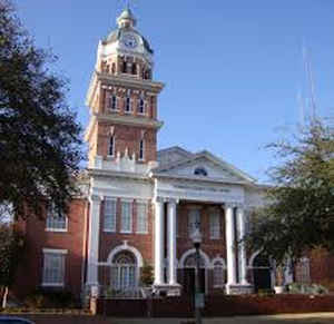
Lowndes County is a county located in the state of Mississippi. Based on the 2010 census, the population was 59,779. Its county seat is
Columbus. The county is named for US Congressman William Jones Lowndes.
Lowndes County comprises the Columbus, MS Micropolitan Statistical Area. Since the late 20th century, it has been designated as one of three
counties in the Golden Triangle region of the state.
Etymology - Origin of Lowndes County Name
Lowndes County is named for US Congressman William Jones Lowndes.
Demographics:
County QuickFacts: CensusBureau Quick Facts
Lowndes County History
The county of Lowndes was erected January 30, 1830, and was named "in memory of the late William Lowndes". William Jones Lowndes (1782-1822) of South Carolina was a United States Congressman from that State (1811-1822) and an earnest supporter of the War of 1812. Henry Clay called him the wisest man he had ever known in the Congress. The Lowndes counties in Alabama and Georgia also were named for him. It was originally the southern part of Monroe County and embraced within its area a part of the present county of Clay. The act creating the county defined its boundaries as follows:
"All that portion of Monroe County lying south of a line commencing at a point on the State of Alabama, where a line running due east from Robinson's Bluff, on the Buttahatchie River, would strike the state line of Alabama; thence from said point, due, west, to said Robinson's Bluff; thence down the said river to its mouth; thence west, to the western boundary line of the county of Monroe, as designated by the act of 1829, extending into the territory occupied by the Chickasaw and Choctaw tribes of Indians, shall form a new county, etc."
December 6, 1831, its limits were extended "to commence on the State line of Alabama, at the house of William
Lucas, and to run from thence in a northwest direction, so as to cross the Robertson road, at a place on said
Robertson's road, known by the name of Wilson's stand, so as to include said Wilson's stand; and from thence on a
direct line from the place of beginning until said line strikes the Natchez Trail; and from thence north, along the
said Natchez Trail to the northern boundary line of said county of Lowndes." And again December 23, 1833, it was
extended to include "all the territory south of a line, running from the junction of the Buttahatchie River, with
the Tombigbee River, to the northeast corner of Oktibbeha County, and east of and between Oktibbeha County and the
Tombigbee River and north of Noxubee County." Finally in 1872, its northern and western limits were modified, when
some of its area was taken to form part of the county of Clay.
The County Seat is Columbus, it may have been named for an older Eastern city by that name, or it may have been
named directly for Christopher Columbus. A county in North Carolina is named Columbus, and there are county seats
named Columbus in Georgia, Indiana, Kansas, Montana, Nebraska, North Carolina, Ohio and Texas. The first County
Court convened at Columbus, April 12, 1830.
That portion of the county lying east of the Tombigbee River is older historically by fourteen years than the
western part, as the former came under territorial control by the Choctaw cession of 1816, while the western part
was not acquired until the Choctaw cession of 1830. The first white man to reside permanently upon the soil of what
is now Lowndes County, was Maj. John Pitchlyn, the son of an English army officer, who was reared from boyhood among
the Choctaws, and was in after life the sworn interpreter of the United States in various treaties and dealings with
the Choctaws.
The early settlements at Plymouth, West Port, Nashville and Moore's Bluff, are now all extinct, but were important
trading points on the Tombigbee River in the early history of the county. These early settlers were attracted from
the older states by the richness of the county, its contiguity to a fine navigable stream, its mild climate and the
fact that the "Mliitary Road," from New Orleans to Nashville, opened by U. S. troops 1817-1820 offered ready means
of access to the region
Geography: Land and Water
As reported by the Census Bureau, the county has a total area of 516 square miles (1,338 km2), of which, 502 square miles (1,301 km2) of it is land and 14 square miles (37 km2) of it (2.74%) is water.
Neighboring Counties
Bordering counties are as follows:
- Noxubee County (south)
- Oktibbeha County (west)
- Clay County (northwest)
- Monroe County (north)
- Lamar County, Alabama (northeast)
- Pickens County, Alabama (southeast)
Education
Primary and secondary schools
Portions of Lowndes County are served by the Columbus Municipal School District and the Lowndes County School District.
The Columbus Municipal School District includes:
- Columbus High School
- S.D. Lee Middle School
- R.E. Hunt Intermediate School
- Cook Elementary Fine Arts Magnet School
- Fairview Elementary Aerospace & Science Magnet
- Franklin Elementary Medical Sciences & Wellness Magnet School
- Sale Elementary International Studies Magnet
- Stokes-Beard Elementary Technology & Communication Magnet.
The Lowndes County School District has 3 areas, each with an elementary school, a middle school, and a high school:
- Caledonia
- New Hope
- West Lowndes.
Colleges and universities
Lowndes County is home of Mississippi University for Women located in Columbus. Lowndes County is within the service area of the East Mississippi Community College system. The Golden Triangle Campus is located in Mayhew, an unincorporated area in Lowndes County. The system also offers classes at the Columbus Air Force Base Extension in Columbus.


Click Image to Enlarge
