


Click Image to Enlarge
Missouri Counties
Missouri has one hundred and fourteen counties and one independent city. St. Louis City is separate from St. Louis County and is referred to as a "city not within a county." Following the Louisiana Purchase and the admittance of Louisiana into the United States in 1812, five counties were formed out of the Missouri Territory at the first general assembly. Most subsequent counties were apportioned from these five original counties.Bollinger County, Missouri
Bollinger County Education, Geography, and History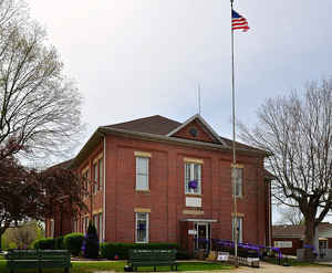
Bollinger County is a county located in the southeastern part of the state of Missouri. As of the 2010 US Census, the county's
population was 12,363. The county seat is Marble Hill. The county was officially organized in 1851.
Bollinger County is part of the Cape Girardeau, MO-IL Metropolitan Statistical Area. The county is the home of the Missouri dinosaur and Blue
Pond, the deepest natural pond in Missouri, is located in the southern portion of the county.
Etymology - Origin of Bollinger County Name
Named for George F. Bollinger, pioneer settler and Missouri legislator.
Demographics:
County QuickFacts: CensusBureau Quick Facts
History of Bollinger County
Organized by an act of the State Legislature, approved March 1, 1851; formed of portions of Wayne, Cape Girardeau, and Stoddard Counties. It was named in honor of Colonel George Frederick Bollinger (1770-1842), who was born in North Carolina of Swiss parentage. In 1796 Colonel Bollinger settled on Whitewater River, then in the district of Cape Girardeau. Bollinger became acquainted with Louis Lorimier, commandant of the post at Cape Girardeau, who under Spanish directions, promised him concessions of land if he would bring more settlers to the district. Bollinger went back to North Carolina and returned with his wife and twenty colonists and families. This group crossed the Mississippi River at Ste. Genevieve January 1, 1800. The group included Mathias, John, Henry, William, Daniel and Philip Bollinger and families; Peter and Conrad Stutler, Joseph Nyswonger, George and Peter Grount, Peter Crytes (or Crites), John and Jacob Cotner, John and Isaac Miller, Frederick Limbough, Leonard Welker, and Frank Slinkard. All were of German or Swiss parentage and members of the German Reformed Church. According to Spanish law, up to 800 arpens (640 acres) of land along Whitewater River from the present Whitewater at Burfordsville and Millersville in Cape Girardeau County. Soon after their settlement Larimier ordered the settlers to form a company of militia, and they were organized under the command of George Frederick Bollinger who was given the title of major. Bollinger built one of the best mills in the county (at what is now Burfordville). Other settlers followed these, settling near present Zalma, on Hog Creek, on Crooked Creek, and on Whitewater Creek, and in 1805 Rev. Samuel Weiberg (or Whybark) came from North Carolina at Bollinger's invitation to establish a German Reformed Church. Major Bollinger was made a member of the first Territorial Assembly, and a member of the State Senate for a number of terms. In 1828 he was president pro tem of the Senate, and in 1836 was a presidential elector. He died in 1842, seven years before Bollinger County was organized. On March 24, 1851, the first county court was organized at the home of John Stevens, on Hurricane Creek. The judges were Reuben Smith, John Stephens, and Drury Massey. The first sheriff was William C. Grimsley, and the clerk was O.E. Snider. A courthouse was erected which burned in 1866 with some of the county records. A second courthouse was erected which burned in 1884. Then Lutesville, a railroad town and ambitious, tried to get the courthouse, but this proposition was defeated at the November, 1884 election. In 1885 the present courthouse was built. Bollinger County was divided into six townships in 1851: Union, German, Lorance, Fillmore, and Wayne. In 1872 two new townships, Crooked Creek and Whitewater were created from Union and German, and in 1918 the name of German Township was changed to Scopus. (Douglass I 313, Conard I, Houck II 182-192, Goodspeed 275-282)
Source: Hamlett, Mayme L. "Place Names Of Six Southeast Counties Of Missouri." M.A. thesis., University of Missouri-Columbia, 1938.
Geography: Land and Water
As reported by the Census Bureau, the county has a total area of 621 square miles (1,610 km2), of which 618 square miles (1,600 km2) is land and 3.3 square miles (8.5 km2) (0.5%) is water. The county's terrain ranges from the Mississippi Delta flatlands in the south to the Ozark Hills in the north.
Neighboring Counties
Bordering counties are as follows:
- Perry County (north)
- Cape Girardeau County (east)
- Stoddard County (south)
- Wayne County (southwest)
- Madison County (northwest)
Education
As of 2007, 70.7% of residents 25 years of age and older in Bollinger County had a high school diploma or higher as their highest educational attainment while 6.9% had a bachelor's degree or higher.
Public schools
Leopold R-III School District - Leopold
Meadow Heights R-II School District - Patton
Woodland R-IV School District - Marble Hill
Zalma R-V School District - Zalma


Click Image to Enlarge
