


Click Image to Enlarge
Missouri Counties
Missouri has one hundred and fourteen counties and one independent city. St. Louis City is separate from St. Louis County and is referred to as a "city not within a county." Following the Louisiana Purchase and the admittance of Louisiana into the United States in 1812, five counties were formed out of the Missouri Territory at the first general assembly. Most subsequent counties were apportioned from these five original counties.Henry County, Missouri
Henry County Education, Geography, and History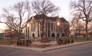
Henry County is a county located in the western portion of the state of Missouri. Based on the 2010 census, the population was 22,272. Its county seat is Clinton. The county was organized December 13, 1834 as Rives County but was renamed in 1841 for Revolutionary War patriot Patrick Henry. The county originally had been named after William Cabell Rives, who was then serving as a US Senator from Virginia. However, Rives lost popularity in Missouri after he joined the Whig Party.
Etymology - Origin of Henry County Name
Named for Patrick Henry, Revolutionary patriot. Originally organized as Rines county, the name was changed to Henry on October 15, 1841, by an act of the legislature.
Demographics:
County QuickFacts: CensusBureau Quick Facts
History of Henry County
In the central west part of Missouri. Organized in 1835 under the name of Rives (q.v.). In 1820 Lillard County, now Lafayette County, was organized. This included Lafayette, Johnson, Cass, Jackson, Henry, and a part of St. Clair and Bates. The first municipal division of Lillard County was Lexington Township. In 1830 Davis and Blackwater Townships were organized. Davis included the territory in Shawnee, Fields Creek, Clinton, and Fairview Townships; Blackwater included Windsor, Tebo, Springfield, Deer Creek, Leesville, Bethlehem, and Osage Townships. These two townships passed out of existence, and in 1832 Tebo Township was organized and included the territory in Henry and Johnson. In May, 1834 Springfield Township was organized and included Windsor, Tebo, Springfield, Deer Creek, Leesville, Bethlehem, and Osage Townships. The remaining townships, Shawnee, Fields Creek, Clinton and Fairview were included in Tebo Township. In 1835 Rives County was organized. In 1841 the name Rives was changed to Henry in honor of Patrick Henry (1736-1799), the famous American orator and statesman. (Lamkin's HIST. HENRY (1919), 79, 80, 84, 87, 104-105)
Source: Johnson, Bernice E. "Place Names In Six Of The West Central Counties Of Missouri." M.A. thesis., University of Missouri-Columbia, 1933.
Geography: Land and Water
As reported by the Census Bureau, the county has a total area of 732 square miles (1,900 km2), of which 697 square miles (1,810 km2) is
land and 35 square miles (91 km2) (4.8%) is water.
Neighboring Counties
Bordering counties are as follows:
- Johnson County (north)
- Pettis County (northeast)
- Benton County (east)
- St. Clair County (south)
- Bates County (west)
- Cass County (northwest)
Education
Public schools
Calhoun R-VIII School District- Calhoun
Clinton School District - Clinton
Davis R-XII School District - Clinton
Henry County R-I School District - Windsor
Lakeland R-III School District - Deepwater/Lowry City
Leesville R-IX School District - Clinton
Montrose R-XIV School District - Montrose
Shawnee R-III School District - Chilhowee
Private schools
Windsor Amish Schools - Windsor (01-08) - Amish
St. Mary' School - Montrose (01-08) - Roman Catholic
Holy Rosary Catholic School - Clinton (PK-08) - Roman Catholic
Clinton Christian Academy - Clinton (K-09) - Nondenominational Christian


Click Image to Enlarge
