


Click Image to Enlarge
Missouri Counties
Missouri has one hundred and fourteen counties and one independent city. St. Louis City is separate from St. Louis County and is referred to as a "city not within a county." Following the Louisiana Purchase and the admittance of Louisiana into the United States in 1812, five counties were formed out of the Missouri Territory at the first general assembly. Most subsequent counties were apportioned from these five original counties.Johnson County, Missouri
Johnson County Education, Geography, and History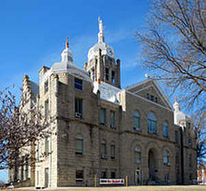
Johnson County is a county located in western portion of the state of Missouri. Based on the 2010 census, the population was 52,595.Its
county seat is Warrensburg. The county was formed December 13, 1834 from Lafayette County and named for Vice President Richard M. Johnson.
Johnson County comprises the Warrensburg, MO Micropolitan Statistical Area, which is also included in the Kansas City-Overland Park-Kansas
City, MO-KS Combined Statistical Area.
Etymology - Origin of Johnson County Name
Named for R.M. Johnson, Kentucky senator and later vice president.
Demographics:
County QuickFacts: CensusBureau Quick Facts
History of Johnson County
In the west-central part of the state, bounded on the north by Lafayette County, on the east by Pettis County, on the south by Henry and Cass Counties, and on the west by Jackson and Cass Counties. Organized in 1834, and named by Robert Macklin White, a member of the Missouri State Legislature, in honor of Honorable Richard Mentor Johnson (1780-1850), born near Louisville, Kentucky. He served in the War of 1812, and at the Battle of Thames in 1813. It was by his hand that Tecumseh was supposed to have been slain. In 1819 he was elected Senator from Kentucky to fill a vacancy in the United States Senate. In 1829 he was returned to the House of Representatives. In 1836, he was candidate for vice president on the Van Buren ticket, and was elected by the Senate. He was candidate for vice president again in 1840, but was defeated. Originally Johnson County was a portion of Lafayette County. (HIST. JOHNSON 1881, 174)
Source: Johnson, Bernice E. "Place Names In Six Of The West Central Counties Of Missouri." M.A. thesis., University of Missouri-Columbia, 1933.
Geography: Land and Water
As reported by the Census Bureau, the county has a total area of 833 square miles (2,160 km2), of which 829 square miles (2,150 km2) is
land and 3.9 square miles (10 km2) (0.5%) is water.
Neighboring Counties
Bordering counties are as follows:
- Lafayette County (north)
- Pettis County (east)
- Henry County (south)
- Cass County (west)
- Jackson County (northwest)
Education
Public schools
Chilhowee R-IV School District - Chilhowee
Holden R-III School District - Holden
Johnson County R-VII School District - Centerview
Kingsville R-I School District - Kingsville
Knob Noster R-VIII School District - Knob Noster
Leeton R-X School District - Leeton
Warrensburg R-VI School District - Warrensburg
Private schools
Johnson County Christian Academy - Centerview (K-9) - Nondenominational Christian
Post-secondary
University of Central Missouri - Warrensburg - A public, four-year university


Click Image to Enlarge
