


Click Image to Enlarge
Nebraska Counties
There is ninety-three counties in state of Nebraska. Despite the fact that Sarpy County contained the oldest settlement in the state, it was one of the last lands along the river to be recognized by law. Finally, on February 1, 1857, the land "where the cities meet the country" was officially created.Lincoln County, Nebraska
Lincoln County Education, Geography, and History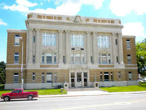
Lincoln County is a county located in the state of Nebraska. Based on the 2010 census, the population was 36,288. Its county seat is
North Platte. Despite the county's name, the state capital city of Lincoln is not located in or near Lincoln County.
Lincoln County is part of the North Platte, NE Micropolitan Statistical Area.
Etymology - Origin of Lincoln County Name
On Jan. 7, 1860 the Territorial Legislature approved the boundaries of Shorter County, the forerunner to Lincoln County. The county was officially organized in 1866 and the name was changed to honor President Abraham Lincoln, who had been assassinated the previous year.
Demographics:
County QuickFacts: CensusBureau Quick Facts
Lincoln County History
On Jan. 7, 1860 the Territorial
Legislature approved the boundaries of Shorter County, the forerunner to Lincoln
County. In those days this area was the site of considerable hostilities between
the Sioux and Cheyenne Indians and the federal government moved in troops to
provide protection for the growing number of settlements along the Platte River
Valley.
To accommodate the troops, Fort McPherson was built near Cottonwood Canyon in
1863. In addition to controlling Indian tensions, the soldiers stationed here
also were assigned to protect dignitary hunting parties that would occasionally
come to the area. Buffalo Bill Cody, a name deeply embedded in the history of
this area, served as scout and guide for many of these hunters.
The county was officially organized in 1866 and the name was changed to honor
President Abraham Lincoln, who had been assassinated the previous year. The
county's boundaries would be redefined again in 1871 to reflect its present
dimensions.
Another name long associated with Lincoln County is that of the Union Pacific
Railroad. As the railroad pushed west in the 1860s, North Platte developed into
one of the prominent railroad towns along the route. It maintains that status
today. The railroad's early influence contributed immensely to the development
of the county. Evidence of this can be seen in the following excerpts from one
of the company's advertisements:
"Union Pacific Railroad ... has land grants direct from the government ...
1,500,000 acres of choice farming lands on the line of the road ... in the Great
Platte Valley. Now for sale for cash or credit at low rates of interest.
Convenient to markets both east and west. Prices range from $2.50 to $10.00 per
acre."
In 1867 the county seat was moved from Cottonwood Springs to North Platte. The
county's first courthouse was built in 1874. After the turn of the century plans
began being made for the present courthouse, which was completed in 1920.
Geography: Land and Water
As reported by the Census Bureau, the county has a total area of 2,575 square miles (6,670 km2), of which 2,564 square miles (6,640 km2)
is land and 11 square miles (28 km2) (0.4%) is water.
It is the third-largest county in Nebraska by area.
Neighboring Counties
Bordering counties are as follows:
- McPherson County (northwest)
- Logan County (northeast)
- Custer County (east)
- Dawson County (east)
- Frontier County (southeast)
- Hayes County (southwest)
- Perkins County (west)
- Keith County (west)
Education


Click Image to Enlarge
