

Click Image to Enlarge
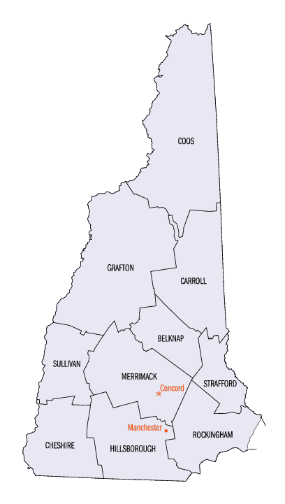
New Hampshire Counties
There are currently ten Counties in the state of New Hampshire. Five of the counties were created in 1769, when New Hampshire was still an English colony and not a state, during the first subdivision of the state into counties. The last counties created were Belknap County and Carroll County, in 1840.Coös County, New Hampshire
Coös County Education, Geography, and History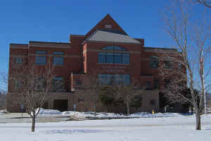
Coös County, frequently spelled Coos County, is a county in the state of New Hampshire. Based on the 2010 census, the population was
33,055, the least of any New Hampshire county. The county seat is Lancaster.
The two-syllable pronunciation is sometimes indicated with a dieresis, notably in the Lancaster-based weekly newspaper The Coos County
Democrat and on some county-owned vehicles. The county government uses both spellings interchangeably.
Coos County is part of the Berlin, NH-VT Micropolitan Statistical Area. It is the only New Hampshire county on the Canada-United States
border, south of the province of Quebec, and thus is home to New Hampshire's only international port of entry, the Pittsburg-Chartierville
Border Crossing.
Etymology - Origin of Coos County Name
Coös County, named for the Indian word for pines, cohos. The name Coös derives from the Algonquian Indian term meaning crooked, the Indian name of the Connecticut River, which rises in the northernmost end of the county.
Demographics:
County QuickFacts: CensusBureau Quick Facts
Coos County History
Coos County, named for the Indian word for pines, cohos, encompasses the entire northern section of the state, covering 1,804 square miles, 20% of the land area of the state of New Hampshire. The Abnaki word, also spelled cowass, cohoss, and coo-ash, was
used to identify inhabitants of the region. Those living in the area were customarily know as "Coo-ashe-aukes", or "dwellers in the pine tree place."
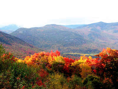
The first reference to the area is found in the 1704 records of New Hampshire, which names the area "Cohoss - a large and valuable tract of land along the Connecticut River." Over 90% of the land is forested, 24% of which is either State or National Forest. The area is well known as an outstanding
area for recreational ski areas, campsites, picnic grounds, snowmobiling, fishing, and hunting. More than half of the moose population (2,600 out of 5,000) and the bear population (13,500 out of 25,000) are in Co? County. The twenty towns and one city are chiefly located along the Connecticut and
Androscoggin Rivers Valleys.
The first white settlers of the area arrived in 1763. Once a pathless wilderness claimed only by wild animals and the Indians of the Abnaki tribes, the population had swelled to 3,000 when the county was established in 1803. Growth in the North Country during the 19th century was quite rapid, at
least 3 times that of the state as a whole. Although the population reached 39,000 by 1930, it has since diminished to less than 35,000.
Coos County is the northern-most of the ten New Hampshire counties, isolated from the rest of the state by a mountainous terrain. The average number of days without killing frost averages from 100 to 120 days in the northern tip, limiting agricultural development. Seventy -five percent of the county
is characterized by steep to very steep slopes. Mt. Washington is one of the major attractions of the county, as the highest peak in the northeast at 6,288 feet above sea level with the most severe weather conditions ever recorded.
Coos County is unique in many ways. It is bordered by Canada to the north, Vermont to the west, Maine to the east, and Grafton and Carroll counties to the south. In addition to being the largest of the state's ten counties and the one with the smallest population, it also has 23 unincorporated
places, geographic entities with no formal government. The County, serving as the local governing board, prepares individual budgets for the 17 unincorporated places which are outside of the White Mountain National Forest. Since 1988, as the result of state legislation, it has become responsible for
the transportation and education of the students, and entering into contracts with abutting towns for police, fire, solid waste, and other municipal services. A voluntary planning board developed and administers the zoning, site plan review, and subdivision regulations.
Coos County's economy is tied to two principal activities, manufacturing and tourism. Lumber and wood products and paper are traditionally strong industries in the North Country. Three of the four pulp and paper mills in New Hampshire are located in the county. A large number of residents are
employed in construction, banking, trucking, retail trade, education, and health services. The county is home to hospitals in each of the three major population centers, Colebrook, Lancaster, and Berlin.
Coos County natives hold tremendous pride in being from the North Country. Those residents who are "from away" take special delight in being mistaken for real natives. It's a wonderful place to call home.
Geography: Land and Water
As reported by the Census Bureau, the county has a total area of 1,831 square miles (4,740 km2), of which
1,800 sq mi (4,660 km2) is land and 31 square miles (80 km2) (1.70%) is water.
Much of its mountainous area is reserved as national forest, wilderness, state parks and other public areas. These
encompass most of the northern portion of the White Mountains, including all the named summits of the Presidential
Range (though one, Mt. Webster's, lies about 200 feet (61 m) from the county line). Mt. Washington's peak is the
highest in the Northeast.
Neighboring Counties
Bordering counties are as follows:
- Oxford County, Maine (east)
- Carroll County (southeast)
- Grafton County (southwest)
- Essex County, Vermont (west)
- Coaticook Regional County Municipality, Quebec, Canada (north)
- Le Haut-Saint-Francois Regional County Municipality, Quebec, Canada (north)
- Le Granit Regional County Municipality, Quebec, Canada (north)
Education


Click Image to Enlarge
