

Click Image to Enlarge
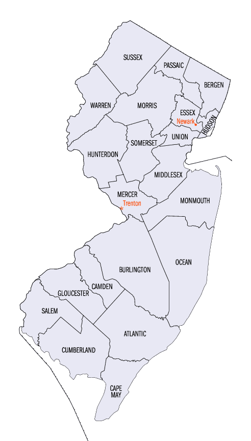
New Jersey Counties
New Jersey has twenty-one counties. New Jersey's first counties were created as administrative districts within each province, with East Jersey split in 1675 into Bergen, Essex, Middlesex and Monmouth counties, while West Jersey's initial counties of Burlington and Salem date to 1681. The most recent county created in New Jersey was Union County, created in 1857.Warren County, New Jersey
Warren County Education, Geography, and History
Warren County is a county located in the state of New Jersey. Based on the 2010 census, the population was 108,692
Warren County was incorporated by an Act of the New Jersey Legislature on November 20, 1824, from portions of Sussex County. Its county seat
is Belvidere. At its creation, the county consisted of the townships of Greenwich, Independence, Knowlton, Mansfield, Oxford, and Pahaquarry
(now defunct). The county was named for Joseph Warren, an American hero of the Battle of Bunker Hill.
It is part of the Allentown-Bethlehem-Easton, PA-NJ metropolitan area and is generally considered the eastern border of the Lehigh Valley, and
also shares its western border with the New York City Metropolitan Area, with its northwestern section bordering The Poconos.
Etymology - Origin of Warren County Name
Warren is named for Joseph Warren, an American Revolutionary War general.
Demographics:
County QuickFacts: CensusBureau Quick Facts
Warren County History
After the Wisconsin Glacier melted around 13,000 B.C., the area slowly warmed. At first the area was Tundra, and
later changed to Taiga/Boreal Forests. Water was everywhere in the northern part of the county due to the glacier melt. The water drained
slowly and grasses grew. There was a big lake at Great Meadows. The area was still cold, so grasslands grew first followed by coniferous
forests as the area warmed. Big game such as mastodons came into the area. This is when Paleo Indians moved into the area. Paleo Indians lived
in small groups and traveled in search of game and plants to eat. They were hunter-gathers. They made spear points of jasper and black chert.
They lived near water and moved after game became scarce in the area. Their camp sites are many feet below the present ground surface, making
them difficult to locate.
Native Americans moved into the area but their time of arrival is unknown. Eventually ancestors of the Algonquian-speaking Lenape moved into
the area, perhaps as early as 1000 AD. Clay pottery and the bow and arrow was being invented around 1000 AD. Agriculture also started around
that time, with the cultivation of corn, beans, and squash. Settlements of family groups became more stable, as they could store food in
pottery, as well as procure more game with the bow and arrow. Agriculture contributed to the rise of population density in areas where crops
could be grown. The Lenape would tend their oval gardens during the spring and summer months. They fished with nets or by hand in the shallow
rivers. The Lenape trapped game with deadfalls and snares.
Problems developed in the early 17th century when the Little Ice Age came to North America. With late frost in May and June and frosts in
early August or September, made the growing of crops difficult. Cold weather also made big and small game more difficult to find. Also nut
crops from oak, hickory, beech, walnut, chestnut, failed at times making the supply of these nuts scarce. Rivers froze so fishing became
impossible. Their population had declined after epidemics of infectious diseases, for which they had no acquired immunity, as Native American
populations were separated from Europe for thousands of years and had no immunity. Many Native American populations were weakened from
starvation due to the Little Ice Age, which was coldest during the 17th century. Their important corn, bean and squash crops failed due to
late cold weather and early frosts. As the Native American population declined, more land was available for European settlement. All these
factors along with diseases contacted from Europeans made the Native populations decline dramatically.
Europeans purchased land known as land patents so Native Americans moved west to Ohio or Canada.
After the Dutch started to settle the Hudson River valley in the early 17th century, the settlers established small communities (trading
posts) into Western New Jersey. Due to differing interpretations of land uses and vastly different cultures, the Dutch and Native Americans
had increasing misunderstandings, which led to hostility. In the middle 17th century, there were three wars between the Dutch and Native
Americans, notably the Lenape tribes. In August of 1664 the English had taken control of the area, which the Dutch called New Netherland.
Relations between the British and Native American improved for a while but gradually declined. This led to the French and Indian War of 1754,
which fortified homes or small forts were built from Phillipsburg to Port Jervis, N.Y. along or near the Delaware River. The mountains of
Warren County was the frontier of the war. After the war ended in 1763, there was very few Native Americans left in Warren county.
In the present-day Phillipsburg area, European settlement occurred in the late 17th century. Surveyors from Philadelphia went north along the
Delaware River to survey land. Settlers from Philadelphia moved north into present-day Warren County after colonists purchased land from the
Native Americans. As the Native American population declined, more land was available for European settlement.
By the late 1700s/early 1800s, Phillipsburg, Hackettstown, Belvidere, and Washington emerged as small settlements and served as the
cornerstone communities in lower Sussex County. In 1824, Warren County was established and Belvidere was named as its county seat.
Geography: Land and Water
According to the 2010 Census, the county had a total area of 362.86 square miles (939.8 km2), including 356.92 square miles (924.4 km2) of
land (98.4%) and 5.94 square miles (15.4 km2) of land (1.6%).
Warren County is rolling hills, with the Kittatinny Ridge in the west. Allamuchy Mountain and Jenny Jump Mountain are part of the New York -
New Jersey Highlands, also known as the Reading Prong. Around 450 million years ago, a chain of volcanic islands collided with proto North
America. The chain of islands went over the North American plate, thus the Highlands were created from the island rock and so was the Great
Appalachian Valley. The Highlands is Allamuchy Mountains and the Jenny Jump Mountains. Thus, Warren County was born.
Warren County is located in two valleys of the Great Appalachian Valley. The first is the Kittatinny Valley, which is in the northern part of
the county, and the Lehigh Valley, which is in the southern part of the county.
The Lehigh Valley starts at the terminal moraine of the Wisconsin Glacier slightly north of Belvidere. It extends from the Delaware River
south to where the Musconetcong River goes into the Delaware River, northeast to the Jenny Jump Mountains and then along Route 80 to the
Allamuchy Mountains to the terminal moraine near Hackettstown.
The Kittatinny Valley is north of the terminal moraine; it runs north of Belvidere, to south of Great Meadows, then east to the north of
Hackettstown. Towns such as Blairstown, Johnsonburg, Hope and Allamuchy are in the Kittatinny Valley
The highest elevation is 1,600 feet (490 m) above sea level on the Kittatinny Ridge, at two areas just south of Upper Yards Creek Reservoir,
west of Blairstown. The lowest point is the confluence of the Delaware and Musconetcong rivers at the county's southern tip, at 160 feet (49
m) of elevation.
The highest elevation on Allamuchy Mountain is 1,240 feet (380 m) on the ridge northeast of Allamuchy. On Jenny Jump Mountain the highest
point is 1,134 feet (346 m) east of the Shiloh area or south of Interstate 80. Sunfish Pond has an elevation of 1,379 feet (420 m) and upper
Yards Creek Reservoir is at 1,555 feet (474 m).
Neighboring Counties
Bordering counties are as follows:
- Sussex County, New Jersey - northeast
- Morris County, New Jersey - east
- Bucks County, Pennsylvania - south
- Hunterdon County, New Jersey - south
- Northampton County, Pennsylvania - west
- Monroe County, Pennsylvania - northwest
Education
Colleges
Centenary College is a private college located in Hackettstown that is affiliated with the United Methodist Church.
Warren County Community College, in Washington Township, offers both associate and bachelor's degree programs and certificate programs. The
College serves approximately 1,700 full-time and part-time students, in addition to students in non-credit programs and courses. The College
is able to offer bachelor programs through partnerships with four-year colleges.


Click Image to Enlarge
