


Click Image to Enlarge
New York Counties
There are sixty-two counties in the State of New York. The first twelve counties in New York were created immediately after the British annexation of the Dutch colony of New Amsterdam, although two of these counties have since been abolished. The most recent county formation in New York was in 1912, when Bronx County was created from the portions of New York City that had been annexed from Westchester County.Niagara County, New York
Niagara County Education, Geography, and History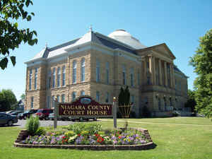
Niagara County is a county located in the state of New York. Based on the 2010 census, the population was 216,469. The county seat is
Lockport. The county name is from the Iroquois word Onguiaahra; meaning the strait or thunder of waters.
Niagara County is part of the Buffalo-Niagara Falls metropolitan area, and its Canadian border is the province of Ontario.
Etymology - Origin of Niagara County Name
from an Indian word meaning "bisected bottom lands"
Demographics:
County QuickFacts: CensusBureau Quick Facts
Niagara County History
Niagara County was taken from Genesee in 1808. Greatest length E. and W. 30; breadth N. and S. 21 miles. The word Niagara is of Indian origin, and signifies across the neck or straight. The streams are few, and with the exception of Eighteen Mile, Johnson's and Tonawanta creeka, and Niagara river, are inconsiderable. In 1796, exclusive of the occupants of Forts Niagara and Schlosser, there was but one white family in the territory now forming this county. The proposed line for a ship canal, from the Niagara river above the falls to Lewiston, lies wholly within the county, commencing near Gill creek and the site of old Fort Schlosser. A railroad runs from Lockport aand another from Buffalo to the Niagara Falls. A branch has been made from Lewiston to intersect the Lockport and Niagara Falls railroad, a distance of about 2 miles. The Erie canal enters Tonawanta creek near its mouth. The creek is used for 12 miles as a canal by a tow-path on its bank. At Pendleton village, the canal leaves the creek and turns in a northeasterly direction across the mountain ridge, with a deep cut of about three miles through rock averaging 20 feet; and then descending 60 feet, by five double combined locks of 12 feet each, it passes out of the county south of the Ridge road. The county is divided into 12 towns. (Historical Collections of the State of New York, Past and Present, John Barber, Clark Albien & Co. 1851)
Niagara County's geographic position is the reason for its geo-political prominence as an Outpost of Empires and as stage for stories that are a significant part of American history. The international Niagara River borders Canada and Western part of the county while Lake Ontario is the northern boundry. Tonawanda Creek is the Southern boundry thus suggesting a peninsula feature.
Geography: Land and Water
Niagara County is in the extreme western part of New York State, just north of Buffalo and adjacent to Lake
Ontario on its northern border and the Niagara River and Canada on its western border. The border results in a fair
number of Illegal Immigration cases, though these are more common to the east where the border is across land rather
than a lake or river.
The primary geographic feature of the county is Niagara Falls, which has eroded seven miles south over the past
12,000 years since the last Ice Age. The Niagara River and Niagara Falls, are in effect, the drainage ditch for four
of the Great Lakes which constitute the largest supply of fresh water in the world. The water flows north from Lake
Erie, then through the Niagara River, goes over Niagara Falls, and then on to Lake Ontario and the St. Lawrence
River, eventually emptying into the North Atlantic Ocean. Today, tourists and visitors to the Falls only see half of
the natural water flow over the Falls, since the other half has been taken for hydroelectric power purposes. Both
the American and Canadian side of the Niagara River have massive electrical power plants.
The spectacular Niagara Gorge is the path Niagara Falls has taken over thousands of years as it continues to erode.
Niagara Falls started at the Niagara Escarpment which cuts Niagara County in half in an East-West direction. North
of the Escarpment lies the Lake Ontario plain, which is a fertile flatland that is used to grow grapes, apples,
peaches and other fruits and vegetables.
As reported by the Census Bureau, the county has a total area of 1,140 square miles (2,952 km2), of which, 523
square miles (1,354 km2) of it is land and 617 square miles (1,598 km2) of it (54.12%) is water.
Neighboring Counties
Bordering counties are as follows:
- Orleans County, New York - east
- Genesee County, New York - southeast
- Erie County, New York - south - boundary is Tonawanda Creek
- Province of Ontario - west - International border - boundary is the Niagara River
- Lake Ontario - north - with Canada on the opposite shore.
Education
Niagara University is located in Lewiston, New York. Niagara County Community College is located in Sanborn, New York. Many Niagara County residents also attend Erie and other Western New York County Schools. In the Buffalo Metro area there more than 20 public and private colleges and universities in Buffalo and its environs offer programs in technical and vocational training, graduate, and professional studies.


Click Image to Enlarge
