


Click Image to Enlarge
New York Counties
There are sixty-two counties in the State of New York. The first twelve counties in New York were created immediately after the British annexation of the Dutch colony of New Amsterdam, although two of these counties have since been abolished. The most recent county formation in New York was in 1912, when Bronx County was created from the portions of New York City that had been annexed from Westchester County.Orleans County, New York
Orleans County Education, Geography, and History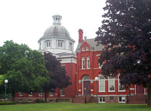
Orleans County is a county located in the state of New York. Based on the 2010 census, the population was 42,883. The county seat is
Albion. The name is in honor of the French Royal House of Orleans.
Orleans County is part of the Rochester, NY Metropolitan Statistical Area.
Etymology - Origin of Orleans County Name
Named after the French Royal House of Orleans
Demographics:
County QuickFacts: CensusBureau Quick Facts
Orleans County History
Orleans County, was taken from Genesee in 1824. It is 24 miles long E. and W., and 18 miles broad N. and S. It is centrally distant from Albany 257, and from New York 302 miles. The summit of the mountain ridge extends across the county at an elevation of about 340 feet above Lake Ontario. Parallel with this, on the alluvial way, runs the ridge road. With these exceptions, the face of the country 15 generally level. The soil, mostly clay and argillaceous loam, is highly fertile. Grain is raised in considerable quantities. The Erie canal passes centrally through the county. The whole county was included in the grant to Massachusetts. The towns of Barre, Carlton, Gaines, Ridgeway, Shelby, and Yates belonged to the Holland Land Company; while Murray, Clarendon, and Kendall belonged to the Pulteney estate. The county was chiefly settled by New Englanders, and is divided into 9 towns. (Historical Collections of the State of New York, Past and Present, John Barber, Clark Albien & Co., 1851)
Orleans is a small Western New York county, situated on the southern shore of Lake Ontario. Its area is generally flat with elevations ranging from 247 to 737 feet above sea level. About two-thirds of the area is developed farmland but 200 years ago it was a swampy wilderness where "Indians came only for hunting and fishing."To them, the area was known as "the sick country."Archeologists have discovered numerous Indian campsites but only one permanent fortification destroyed around 1650. It was not until 1804 that the first permanent settler came here to purchase land from the Holland Land Company. After 1809, settlement along the Ridge Road (Route 104) was fairly rapid.
Geography: Land and Water
As reported by the Census Bureau, the county has a total area of 817 square miles (2,117 km2), of which, 391
square miles (1,014 km2) of it is land and 426 square miles (1,104 km2) of it (52.12%) is water. The high proportion
of water is due to the extension of Orleans County north into Lake Ontario to the Canadian border (a line of
latitude running through the middle of the lake). The distance from the Orleans shore north to the international
border is greater than the distance from the shore south to the Genesee County line, meaning the area of Orleans
underwater is actually greater than that above water.
Orleans County is in western New York State, northeast of Buffalo and west of Rochester, on the southern shore of
Lake Ontario.
The Erie Canal passes (east-west) through the middle of the county.
Neighboring Counties
Bordering counties are as follows:
- Lake Ontario and Canada - north
- Monroe County, New York - east
- Genesee County, New York - south
- Niagara County, New York - west
Education
The county is considered to have five school districts, although the actual district boundaries can extend into neighboring counties, and
the same is true for neighboring counties' districts. The five districts, from west to east, are:
Lyndonville Central School District (northern half of western third, roughly covering Lyndonville village and the towns of Yates and Ridgeway)
Medina Central School District (southern half of western third, roughly covering Medina village and the towns of Ridgeway and Shelby)
Albion Central School District (middle third, roughly covering Albion village and the towns of Carlton, Gaines, Albion, and Barre)
Kendall Central School District (northern half of eastern third, roughly covering the towns of Kendall and Murray)
Holley Central School District (southern half of eastern third, roughly covering Holley village and the towns of Murray and Clarendon)
The only post-secondary education available in the county are two branches of Genesee Community College located in Albion and Medina.


Click Image to Enlarge
