


Click Image to Enlarge
North Carolina Counties
North Carolina is divided into one hundred counties. The establishment of North Carolina counties stretches over 240 years, beginning in 1668 with the creation of Albemarle County and ending with the 1911 creation of Avery and Hoke counties. Five counties have been divided or abolished altogether, the last being Dobbs County in 1791.Carteret County, North Carolina
Carteret County Education, Geography, and History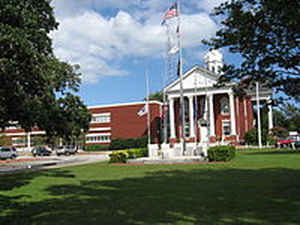
Carteret County is a county located in the state of North Carolina. Based on the 2010 census, the population was 66,469. Its county seat
is Beaufort. The county was created in 1722 as Carteret Precinct and gained county status in 1739. It was named for Sir George Carteret, one
of the 17th century English Lords Proprietor, or for his descendant and heir John Carteret, 2nd Earl Granville.
Carteret County comprises the Morehead City, NC Micropolitan Statistical Area, which is also included in the New Bern-Morehead City, NC
Combined Statistical Area. Most of the county is part of the Crystal Coast.
Etymology - Origin of Carteret County Name
It was named in honor of Sir John Carteret afterwards (1744) Earl of Granville, one of the Lords Proprietors.
Demographics:
County QuickFacts: CensusBureau Quick Facts
Carteret County History
Carteret was formed in 1722 from Craven. It was named in honor of Sir John Carteret afterwards (1744) Earl of Granville, one of the Lords Proprietors. It is in the eastern section of the State and is bounded by the Atlantic Ocean and Onslow, Jones and Craven counties and on the banks by Hyde County. The present land area is 519.84 square miles and the 2000 population was 59,383. Beaufort, established in 1723 and named in honor of Henry Duke of Beaufort, is the county seat.
Geography: Land and Water
As reported by the Census Bureau, the county has a total area of 1,341 square miles (3,470 km2), of which 506 square miles (1,310 km2) is land and 834 square miles (2,160 km2) (62%) is water. It is the third-largest county in North Carolina by total area.
Neighboring Counties
Bordering counties are as follows:
- Craven County (north)
- Pamlico County (north)
- Hyde County (northeast)
- Onslow County (southwest)
- Jones County (northwest)
Education
The county is served by the Carteret County Public Schools. Carteret County Public Schools has 16 schools ranging from pre-kindergarten to twelfth grade. Those 16 schools are separated into three high schools, four middle schools, and nine elementary schools.


Click Image to Enlarge
