


Click Image to Enlarge
North Carolina Counties
North Carolina is divided into one hundred counties. The establishment of North Carolina counties stretches over 240 years, beginning in 1668 with the creation of Albemarle County and ending with the 1911 creation of Avery and Hoke counties. Five counties have been divided or abolished altogether, the last being Dobbs County in 1791.Stokes County, North Carolina
Stokes County Education, Geography, and History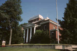
Stokes County is a county located in the state of North Carolina. Based on the 2010 census, the population was 47,401. Its county seat is
Danbury.
Stokes County is included in the Winston-Salem, N.C., Metropolitan Statistical Area, which is also included in the
Greensboro-Winston-Salem-High Point, N.C., Combined Statistical Area.
Etymology - Origin of Stokes County Name
It was named in honor of Captain John Stokes, a soldier of the Revolution, who was seriously wounded at the Waxhaw Massacre when Colonel Buford's Regiment was cut to pieces by Tarlton. After the war Washington appointed him a judge of the United States District Court of North Carolina.
Demographics:
County QuickFacts: CensusBureau Quick Facts
Stokes County History
Stokes was formed in 1789 from Surry. It was named in honor of Captain John Stokes, a soldier of the Revolution, who was seriously wounded at the Waxhaw Massacre when Colonel Buford's Regiment was cut to pieces by Tarlton. After the war Washington appointed him a judge of the United States District Court of North Carolina. It is in the north central section of the State and is bounded by Rockingham, Forsyth and Surry counties and the state of Virginia. The present land area is 451.84 square miles and the 2000 population was 44,711. When Stokes was taken from Surry the old courthouse was ordered to be sold, and the proceeds were to be equally divided between Surry and Stokes and applied towards the erection of new courthouses. The act ordered the first court to be held at the home of Gray Bynum, and all subsequent courts were to be held where the justices designated until the courthouse could be erected. Commissioners were named to select the site and have the public building erected. In 1790 Germantown was laid out on land deeded to the county from Michael and Henry Fry. Germantown remained the county seat until 1849 when Forsyth was taken from Stokes. The act establishing Forsyth county directed that the first court of Stokes after the passage of the act be held at Germantown, at which time the justices were to determine a location for the new courthouse and jail. In 1851 Crawford was established as the county seat. In 1852 Crawford was changed to Danbury. Danbury is the county seat.
Geography: Land and Water
As reported by the Census Bureau, the county has a total area of 456 square miles (1,180 km2), of which 449 square miles (1,160 km2) is
land and 6.8 square miles (18 km2) (1.5%) is water.
The county lies within the Piedmont region of western North Carolina, and most of the terrain consists of gently rolling countryside. However,
the Sauratown Mountains run across the center of the county. The Sauras are named after the Saura Native American tribe which lived in the
county before European settlement. A chain of jagged ridges, the Sauratown Mountains are an isolated remnant of the Blue Ridge Mountains far
to the west. Although the Sauratown Mountains occupy only 5% of Stokes County, they dominate the scenery from almost any direction, abruptly
rising from 800 to 1,700 feet (520 m) above the surrounding terrain. Moore's Knob, the highest point in the chain, rises to 2,579 feet (786
m). Most of the county is less than 1,000 feet (300 m) above sea level. The Dan River runs from the Northwest Corner to the Southeastern
section of Stokes County (Covering over 56 Miles of River Recreation). Stokes County home to Hanging Rock State Park and also has the mass
majority of Belews Lake (located in the southeast corner).
Neighboring Counties
Bordering counties are as follows:
- Patrick County, Virginia - north
- Henry County, Virginia - north
- Rockingham County - east
- Forsyth County - south
- Surry County - west
Education


Click Image to Enlarge
