


Click Image to Enlarge
Ohio Counties
There is eighty-eight counties in the state of Ohio. Washington County the oldest in the state established on July 27, 1788. Noble County was formed on March 11, 1851 from portions of Guernsey, Morgan, Monroe and Washington counties. It was the last county to be formed in Ohio and, therefore, represents the youngest county in the state.Coshocton County, Ohio
Coshocton County Education, Geography, and History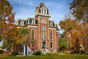
Coshocton County is a county located in the state of Ohio. Based on the 2010 census, the population was 36,901. Its county seat is
Coshocton. The county was formed on January 31, 1810 from portions of Muskingum and Tuscarawas Counties and later organized in 1811. Its name
comes from the Delaware Indian language and has been translated as "union of waters" or "black bear crossing".
The Coshocton, OH Micropolitan Statistical Area includes all of Coshocton County.
Etymology - Origin of Coshocton County Name
The county's name comes from the Delaware Indian word for "black bear town."
Demographics:
County QuickFacts: CensusBureau Quick Facts
Coshocton County History
On January 31, 1810, the State of Ohio authorized the creation of Coshocton County. The county's name comes from the Delaware Indian word for "black bear town." The Delaware Indians' territory centered in modern-day Coshocton County until white settlement led the tribe to move further west in the
years following the American Revolution. County residents began to prosper with completion of the Ohio and Erie Canal. Thanks to the canal, Coshocton became a major commercial center in eastern Ohio during the 1820s and 1830s.
Coshocton County is located in east central Ohio. It is predominantly rural, with less than one percent of the county's 564 square miles consisting of urban areas. The county seat is Coshocton. With a population of 11,682 people, Coshocton was the county's largest community in 2000. The next largest
urban area, West Lafayette, had only 2,313 residents in that year. Coshocton County experienced a slight increase in population - roughly 3.5 percent - between 1990 and 2000. This raised the total number of residents to 36,655 people. The county averages sixty-five people per square mile.
The largest employers in Coshocton County are manufacturing establishments, with service industries a distant second. During the early twentieth century, Coshocton became famous for its advertising products, including calendars, trays, and other items promoting businesses like the Coca-Cola Bottling
Company. In 1999, the per capita income in the county was approximately twenty-one thousand dollars, with 11.5 percent of the people living in poverty.
Among Coshocton County's more prominent residents was William Green, a past president of the American Federation of Labor.
Sources
Coshocton County, Ohio History Central, July 23, 2008,
http://www.ohiohistorycentral.org/entry.php?rec=1916&nm=Coshocton-County
Geography: Land and Water
As reported by the Census Bureau, the county has a total area of 567 square miles (1,470 km2), of which 564 square miles (1,460 km2) is land and 3.6 square miles (9.3 km2) (0.6%) is water
Neighboring Counties
Bordering counties are as follows:
- Holmes County (north)
- Tuscawaras County (east)
- Guernsey County (southeast)
- Muskingum County (south)
- Licking County (southwest)
- Knox County (west)
Education


Click Image to Enlarge
