


Click Image to Enlarge
Ohio Counties
There is eighty-eight counties in the state of Ohio. Washington County the oldest in the state established on July 27, 1788. Noble County was formed on March 11, 1851 from portions of Guernsey, Morgan, Monroe and Washington counties. It was the last county to be formed in Ohio and, therefore, represents the youngest county in the state.Madison County, Ohio
Madison County Education, Geography, and History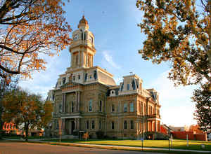
Madison County is a county located in the state of Ohio. Based on the 2010 census, the population was 43,435. Its county seat is London.
The county is named for James Madison, President of the United States and was established on March 1, 1810.
Madison County is part of the Columbus, OH Metropolitan Statistical Area.
Etymology - Origin of Madison County Name
The county was named in honor of James Madison, the fourth president of the United States.
Demographics:
County QuickFacts: CensusBureau Quick Facts
Madison County History
On February 16, 1810, the Ohio government authorized the creation of Madison County. The county was named in honor of James Madison, the fourth president of the United States. The county began to flourish during the 1830s, with the completion of the National Road through Ohio.
Madison County is located in west central Ohio. It is predominantly rural, with less than one percent of the county's 465 square miles consisting of urban areas. The county seat is London. With a population of 8,771 people, London was the county's largest community in 2000. The next largest urban
area, Somerford Township, had only 6,975 residents that same year. Unlike most of Ohio's predominantly rural counties, Madison County experienced an increase in population- 8.5 percent- between 1990 and 2000, increasing the total number of residents to 40,213 people. The main reason for this increase
was the large number of residents from Columbus, in nearby Franklin County, who sought to escape that city's busyness by moving to more rural, neighboring counties. In recent years, Madison County's population has declined by approximately 1.7 percent as residents moved back to Columbus or to other
large cities. Many residents of Ohio's rural communities are seeking better lives and more opportunities in the state's cities. Madison County averages almost eighty-seven people per square mile.
Farming is the largest employer in Madison County, followed closely by manufacturing businesses and government positions. Service industries, such as health care and communications, rank a distant fourth. Over eighty-eight percent of the county's acreage is farmland, with residents ranking second in
soybean and third in corn production in Ohio. The London Correctional Facility employs many of the government workers. In 1999, the per capita income in the county was 21,782 dollars, with 8.7 percent of the people living in poverty.
Most voters in Madison County claim to be independents, yet in recent years, they have overwhelmingly supported Republican Party candidates at the national level.
Sources
Madison County, Ohio History Central, July 24, 2008,
http://www.ohiohistorycentral.org/entry.php?rec=1966&nm=Madison-County
Geography: Land and Water
As reported by the Census Bureau, the county has a total area of 467 square miles (1,210 km2), of which 466 square miles (1,210 km2) is land and 0.8 square miles (2.1 km2) (0.2%) is water.
Neighboring Counties
Bordering counties are as follows:
- Union County (north)
- Franklin County (east)
- Pickaway County (southeast)
- Fayette County (south)
- Greene County (southwest)
- Clark County (west)
- Champaign County (northwest)
Education


Click Image to Enlarge
