


Click Image to Enlarge
Ohio Counties
There is eighty-eight counties in the state of Ohio. Washington County the oldest in the state established on July 27, 1788. Noble County was formed on March 11, 1851 from portions of Guernsey, Morgan, Monroe and Washington counties. It was the last county to be formed in Ohio and, therefore, represents the youngest county in the state.Miami County, Ohio
Miami County Education, Geography, and History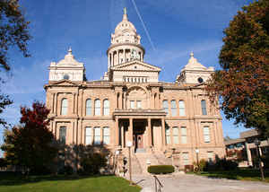
Miami County is a county located in the state of Ohio. Based on the 2010 census, the population was 102,506. Its county seat is Troy. The
county is named for an Indian word of disputed meaning.
Miami County is part of the Dayton, OH Metropolitan Statistical Area.
Etymology - Origin of Miami County Name
Residents named the county in honor of the Miami Indians.
Demographics:
County QuickFacts: CensusBureau Quick Facts
Miami County History
On January 16, 1807, the Ohio government authorized the creation of Miami County. Residents named the county in honor of the Miami Indians. Previously, the county had been part of Montgomery County.
Miami County is located in western Ohio. It is predominantly rural, with less than four percent of the county's 407 square miles consisting of urban areas. The county seat is Troy. With a population of 21,999 people, Troy was the county's largest community in 2000. Many residents of Ohio's rural
communities are seeking better lives and more opportunities in the state's cities, but Miami County's population grew between 1990 and 2000. The county experienced a 6.1 percent population growth rate between 1990 and 2000, bringing the total number of residents up to 98,868. The county averages 243
people per square mile.
Manufacturing businesses, retail positions, and service industries, such as health care and tourism, are Miami County's largest employers. Farming ranks a distant fourth. In 1999, the per capita income in the county was 27,271 dollars, with seven percent of the people living in poverty.
Most voters in Miami County claim to be independents, yet in recent years, they have overwhelmingly supported Republican Party candidates at the national level.
American Indian agent John Johnston lived in Miami County, north of Piqua. The Ohio Historical Soceity maintains his farm, a portion of the Ohio and Erie Canal. and an Ohio Indian at the Piqua Historical Area.
Sources
Miami County, Ohio History Central, July 24, 2008,
http://www.ohiohistorycentral.org/entry.php?rec=1978&nm=Miami-County
Geography: Land and Water
As reported by the Census Bureau, the county has a total area of 410 square miles (1,100 km2), of which 407 square miles (1,050 km2) is land and 3.1 square miles (8.0 km2) (0.8%) is water
Neighboring Counties
Bordering counties are as follows:
- Shelby County (north)
- Champaign County (northeast)
- Clark County (southeast)
- Montgomery County (south)
- Darke County (west)
Education
Public school districts
Bethel Local Schools
Bradford Schools
Covington Exempted Village School District
Miami East Local Schools
Milton-Union Exempted Village Schools
Newton Local School District
Piqua City School District
Tipp City Exempted Village School District
Troy City School District


Click Image to Enlarge
