


Click Image to Enlarge
Oklahoma Counties
There are seventy-seven counties in Oklahoma. Oklahoma originally had seven counties when it was first organized as the Oklahoma Territory. These counties were designated numerically, first through seventh. New counties added after this were designated by letters of the alphabet. The first seven counties were later renamed. The Oklahoma Constitutional Convention named all of the counties that were formed when Oklahoma entered statehood in 1907. Only two counties have been formed since thenBryan County, Oklahoma
Bryan County Education, Geography, and History
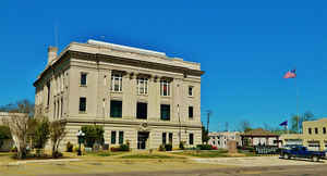
Bryan County is a county located in the state of Oklahoma. Based on the 2010 census, the population was 42,416. Its county seat is
Durant. It is the only county in the United States named for Populist politician William Jennings Bryan.
Bryan County comprises the Durant, OK Micropolitan Statistical Area, which is included in the Dallas-Fort Worth and the Texoma region,
TX-OK Combined Statistical Area.
Etymology - Origin of Bryan County Name
Named for William Jennings Bryan, three times nominated for president of the United States, and an active adviser of the majority party in the State Constitutional Convention.
Demographics:
County QuickFacts: CensusBureau Quick Facts
Bryan County History
The area now known as Bryan County was occupied by the Choctaw Tribe in 1831-2, and became part of Choctaw Nation's
Blue County. In 1845, the tribe opened Armstrong Academy for boys near the community of Bokchito. The academy served as Chahta Tamaha, the
Choctaw capital, during the Civil War. Bloomfield Academy, a school for Chickasaw girls opened in 1852, just south of the present town of
Achille.
The Chickasaw tribe bought part of the Choctaw allocation prior to the Chickasaw migration to Indian Territory. The western quarter of
today's Bryan County thus became part of the Chickasaw District in 1837. When the two tribes formally separated into two distinct nations
in 1855, the Chickasaw District became the Chickasaw Nation.
The Butterfield Overland Mail and Stage route followed the older Texas Road across the present county during the late 1850s. General
Albert Pike established Fort McCulloch for the Confederate Army near the present town of Kenefic on the Blue River. Although no Civil War
battles occurred in the vicinity, the fort was garrisoned by more than a thousand Indian troops allied with the Confederates.
Several new towns were created after the Missouri, Kansas and Texas Railway (Katy) built a north-south line through this area in 1872. One
such town was Colbert, which became the seat of Blue County and the largest town in the Choctaw Nation. The St. Louis, San Francisco and
New Orleans Railroad, later bought by the St. Louis and San Francisco Railway (Frisco), built an east-west line in 1903.
Just prior to statehood, when all tribal governments were dissolved, Blue County was extinguished. Bryan County was officially established
on November 16, 1907, and Durant became the county seat.
Oklahoma History Center
Named for Democratic presidential candidate William Jennings Bryan, a contributor to the 1907 Oklahoma Constitution,
Bryan County is located in the south-central portion of the state. Bordering on the east is Choctaw County, on the north
are Atoka and Johnston counties, on the west is Marshall County, and on the south is the Red River and Texas. Bryan is
separated from Marshall County by the Roosevelt Bridge and Lake Texoma. Covering a total land and water area of 943.43
square miles, Bryan County lies in the Coastal Plains physiographic region, within the Red River watershed, with major
drainage provided by the Blue River. The Washita River, formerly flowing north-south between Bryan and Marshall
counties, is now impounded in Lake Texoma. The county is served by US Highways 69/75 north-south and 70 east-west. At
the beginning of the twenty-first century twelve incorporated towns existed in the county: Armstrong, Bennington,
Bokchito, Caddo, Calera, Colbert, Durant (County Seat), Hendrix, Kemp, Kenefic, Mead, and Silo....BRYAN
COUNTY
Geography: Land and Water
As reported by the Census Bureau, the county has a total area of 944 square miles (2,440 km2), of which 904 square miles (2,340 km2) is land and 39 square miles (100 km2) (4.2%) is water. The county is in the Coastal Plains physiographic region, and is mostly drained by the Blue River. The Washita River originally drained much of the western part of the county, but now empties into Lake Texoma, which forms much of the southern boundary of the county. The county is a major part of the Texoma region.
Neighboring Counties
Bordering counties are as follows:
- Atoka County (north)
- Choctaw County (east)
- Lamar County, Texas (southeast)
- Fannin County, Texas (south)
- Grayson County, Texas (southwest)
- Marshall County (west)
- Johnston County (northwest)
Education


Click Image to Enlarge
