


Click Image to Enlarge
Oregon Counties
There are thyirty-six counties in the state of Oregon. The Oregon Constitution does not explicitly provide for county seats.Deschutes County, Oregon
Deschutes County Education, Geography, and History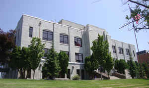
Deschutes County is a county located in the state of Oregon. Based on the 2010 census, the population was 157,733. The county seat is
Bend. The county was created in 1916 out of part of Crook County and was named for the Deschutes River, which itself was named by
French-Canadian trappers of the early 19th century. It is the political and economic hub of Central Oregon.
Deschutes comprises the Bend-Redmond, OR Metropolitan Statistical Area.
Etymology - Origin of Deschutes County Name
It was named for the Deschutes River which flows through the county. Early fur traders had called the river Riviere des Chutes, which means "River of the Falls."
Demographics:
County QuickFacts: CensusBureau Quick Facts
Deschutes County History
Deschutes County was created from the
western portion of Crook County on December 13, 1916. It was named for the
Deschutes River which flows through the county. Early fur traders had called the
river Riviere des Chutes, which means "River of the Falls." The county
encompasses 3,055 square miles and is located in the central portion of the
state. Geographically, the county includes portions of the Cascade Mountains and
the central high desert plateau. It is bounded by Jefferson County to the north,
Crook County to the east, Klamath and Lake Counties to the south, and Lane and
Linn counties to the west.
The county seat is located in the city of Bend which was incorporated in 1905.
The name Bend was derived from "Farewell Bend," the designation used by early
pioneers to refer to the location along the Deschutes River where the town
eventually was platted. County offices were first located in two rooms of the
O'Kane Building and later moved into an office building constructed by the
Deschutes County Investment Company. The county court met there from 1917 to
1935. A county jail was completed 1918. In 1935 the county court decided to
purchase the old brick high school to serve as the courthouse. In 1937 the
courthouse and most of the early county records were destroyed by fire. The
greatest loss of records was in the county clerk's office. The state fire
marshal investigated the cause of the fire, but arson was never proved. A new
courthouse was constructed in 1940 and an addition was built in 1978. The
Deschutes Services Center opened in 2004 and houses a number of county offices,
including the clerk, assessor and commissioners.
The first meeting to organize county government was held in the O'Kane Building.
Appointments were made for the positions of district attorney, county judge, two
commissioners, clerk, assessor, treasurer, surveyor, superintendent of schools,
coroner, physician, and sheriff. The county judge position, which had juvenile
jurisdiction, was abolished in 1971 and replaced by a third county commissioner.
In that year the county court administrative system was replaced by the
three-member board of commissioners.
Principal industries in the county are tourism, timber, and agriculture, chiefly
cattle and potatoes. The destination resort, Inn of the Seventh Mountain, and
the resort communities of Black Butte and Sunriver, were developed during the
1970s. The Mount Bachelor ski area and High Desert Museum add to the
tourism-based economy in the county as well. Numerous golf courses have been
added in recent years.
The first county census taken in 1920 enumerated a population of 9,622
inhabitants. Deschutes County has experienced the most rapid growth of any
county of the state in recent years. The 2000 population of 115,367 was a 53.91%
increase over 1990. The 2006 population of 152,615 represented an increase of
32.3% over 2000.
Geography: Land and Water
As reported by the Census Bureau, the county has a total area of 3,055 square miles (7,910 km2), of which 3,018 square miles (7,820 km2)
is land and 37 square miles (96 km2) (1.2%) is water.
Neighboring Counties
Bordering counties are as follows:
- Jefferson County (north)
- Crook County (east)
- Harney County (southeast)
- Klamath County (south)
- Lake County (south)
- Lane County (west)
- Linn County (northwest)
Education


Click Image to Enlarge
