


Click Image to Enlarge
Oregon Counties
There are thyirty-six counties in the state of Oregon. The Oregon Constitution does not explicitly provide for county seats.Grant County, Oregon
Grant County Education, Geography, and History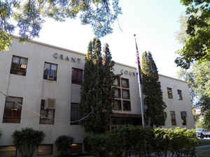
Grant County is a county located in the state of Oregon. Based on the 2010 census, the population was 7,445. The county seat is Canyon
City. It is named for President Ulysses S. Grant, who served as an army officer in the Oregon Territory, and at the time of the county's
creation was a Union general in the American Civil War.
Grant County is included in the 8 county definition of Eastern Oregon.
Etymology - Origin of Grant County Name
Named for General Ulysses S. Grant, commander of the Union Army during the Civil War. Earlier in his military career Grant had been stationed at Fort Vancouver and assigned to protect the increasing number of emigrants traveling the Oregon Trail
Demographics:
County QuickFacts: CensusBureau Quick Facts
Grant County History
Grant County was established on
October 14, 1864, and named for General Ulysses S. Grant, commander of the Union
Army during the Civil War. Earlier in his military career Grant had been
stationed at Fort Vancouver and assigned to protect the increasing number of
emigrants traveling the Oregon Trail. Grant County is located in eastern Oregon
and was created out of Wasco and Umatilla Counties. At that time Grant County
was the largest county in the state. Its size was later reduced by the transfer
of land to Lake County and the creation of Harney and Wheeler Counties. Grant
County shares boundaries with eight counties: Morrow, Umatilla, and Union to the
north; Harney to the south; Malheur and Baker to the east; and Crook and Wheeler
to the west. It has an area of 4,528 square miles.
Prior to 1864 cases brought to court were tried in The Dalles, county seat of
the vast Wasco County. The great distance from the John Day country to The
Dalles made law enforcement a difficult problem and imposed a heavy burden on
citizens who had a need to transact business at the courthouse. The settlers,
feeling an urgent need for a more centralized county government, successfully
petitioned the Legislative Assembly.
The first county court session was convened at Canyon City, the county seat, on
November 7, 1864. Five officials composed the administration of the county: a
judge, sheriff, clerk, and two commissioners. A month later the court appointed
a treasurer, surveyor, superintendent of schools, and coroner. The first county
election held in June 1866, resulted in the election of a county judge, clerk,
and sheriff. The first courthouse was known as "Dunker's Hall," and the present
courthouse was built in 1952. Grant County government consists of a county court
made up of a county judge and two commissioners. The county judge retains
judicial authority only over probate matters.
The first census was taken in 1870 and counted 2,251 persons. The population of
Grant County in 2000 was 7,935. This represented a 1.04% increase from 1990.
After gold was discovered on Whiskey Flat in 1862 the increased population
created a need for county government. It is estimated that within ten days of
the original discovery of gold 1,000 miners were camped along Canyon Creek. Over
$20 million in gold was mined from the Canyon City and Susanville areas.
Following the decline of gold and placer mining, stock raising and agriculture
became the main work of county residents.
Grant County contains the headwaters of the John Day River, which has more miles
of wild and scenic designation than any other river in the United States. More
than sixty percent of the county's land area is under public ownership, and the
county contains parts of four national forests. Principal industries are
forestry, agriculture, livestock, and recreation.
Geography: Land and Water
As reported by the Census Bureau, the county has a total area of 4,529 square miles (11,730 km2), of which 4,529 square miles (11,730
km2) is land and 0.7 square miles (1.8 km2) (0.02%) is water.
Approximately 63% of the land area of the county is controlled by the Federal Government, most of which is controlled by the US Forest
Service, and the Bureau of Land Management. Grant County contains most of the Malheur National Forest and sections of the Wallowa?#8364;"Whitman,
Umatilla and Ochoco National Forests, and has more than 150,000 acres (610 km2) of federally designated Wilderness Areas.
Grant County contains the headwaters of the John Day River, which has more miles of Wild and Scenic River designation than any other river in
the United States.
The elevation of the county varies from 1,820 on the John Day River near Kimberly, to 9,038 feet (2,755 m) at the summit of Strawberry
Mountain. The terrain of the county varies from grassland steppes and rangelands in relatively open or rolling hills and valleys, to steep,
rugged, rocky high-alpine landscapes. Between these, the county contains heavily timbered land, many rolling hills, canyons and mountainous
terrain. Portions of the county are technically high desert, dominated by sagebrush and sparse grasses.
Grant County includes the southern part of the Blue Mountains. One unique characteristic of the typical forestland of the area is the
relatively low density of underbrush. Travelers and emigrants of the 19th century remarked that the absences of underbrush, and the wide
spacing of the trees, made it possible to drive a wagon and team of horses virtually anywhere the grade would permit. The forested land of the
county vary from sparse stands of Western Juniper in more arid, open, or rocky ground, to Sub-Alpine and High-Alpine fir stands in the highest
terrain. Other forested areas (mainly above 3,200 feet (980 m) in elevation) are marked by stands of Ponderosa Pine, Douglas Fir, White Fir,
Western Larch (a deciduous conifer commonly called 'Tamarack'), Lodgepole Pine, Spruce stands in some higher elevation sites and a few stands
of White Pine, as well as Cottonwood trees along some rivers and streams, and Birch and Quaking Aspen groves, mainly at higher elevations.
There is also a rare and isolated stand of Alaskan Yellow Cedar in the Aldrich Mountains. Other flora includes a wide variety of native
grasses and wildflowers, huckleberries, wild strawberries, elderberries, several types of edible mushrooms and Oregon Grape, the state plant.
Non-native Russian Cheatgrass is also prevalent in many areas of the county.
Most of Grant County is drained by the four forks of the John Day River, all of which have their headwaters in the county. The John Day River
system drains some 7,900 square miles (20,000 km2). It is the third longest free-flowing river in the 'lower 48' and has more miles of federal
'Wild and Scenic River' designation than any other river in the United States. The river system in Grant County includes the upper 100 miles
(160 km) of the Main Stem, all of the 112 miles (180 km) of the North Fork, all 75 miles (121 km) of the Middle Fork, and all 60 miles (97 km)
of the South Fork of the John Day River. From Grant County, the lower John Day River flows another 184 miles (296 km) to its confluence with
the Columbia River. The southeastern corner of the county includes the headwaters of the Malheur and Little Malheur rivers, which find their
way to the Snake River. The southern part of Grant County includes the northern-most reaches of the Great Basin, including the Silvies River
watershed, which flows south into Harney Lake in the High Desert of Eastern Oregon. A small area in the southwestern corner of Grant County is
in the Crooked River and Deschutes River watersheds.
Neighboring Counties
Bordering counties are as follows:
- Malheur County (southeast)
- Harney County (south)
- Crook County (west)
- Wheeler County (west)
- Morrow County (north)
- Umatilla County (north)
- Union County (northeast)
- Baker County (east)
Education


Click Image to Enlarge
