


Click Image to Enlarge
Oregon Counties
There are thyirty-six counties in the state of Oregon. The Oregon Constitution does not explicitly provide for county seats.Klamath County, Oregon
Klamath County Education, Geography, and History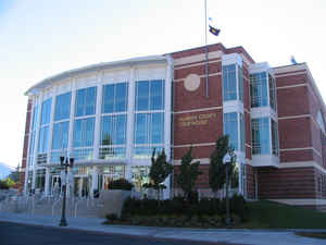
Etymology - Origin of Klamath County Name
Named after a tribe of Indians which white travelers called the Klamath, also spelled Clammite.
Demographics:
County QuickFacts: CensusBureau Quick Facts
Klamath County History
Klamath County was established on
October 17, 1882. It was created from the western part of Lake County and named
after a tribe of Indians which white travelers called the Klamath, also spelled
Clammite.
Klamath County is situated in south central Oregon. The county is bounded on the
south by California, on the east by Lake County, on the north by Deschutes
County, and on the west by Jackson and Douglas Counties. The county, Oregon's
fourth largest, has 6,135 square miles.
When the Legislative Assembly created Klamath County in 1882, it designated
Linkville as the county seat, although it gave the voters the chance to select
another site at the 1884 general election. Linkville was renamed Klamath Falls
in 1893.
In 1888 the county acquired its first courthouse for $3,500. Previously a school
or rented commercial premises housed county offices. By 1912 the need for a new
courthouse was pressing. However, for the next thirteen years a dispute raged
over its location and which of the two courthouses being built would be
accepted. The first courthouse, known as the Hot Springs Courthouse, was
designed along Grecian architectural lines, but, due to law suits and recall
elections only the exterior was finished. When construction stopped, $112,000
had been spent, with an additional $60,000 needed to complete the project. It
was torn down in 1927 to make way for the Klamath Union High School. In 1918
construction began on another courthouse, known as the Main Street Courthouse
which was built next to the existing one. In spite of injunctions to halt
construction, the work was completed within a year, but the building was not
fully occupied until 1923, when all legal questions were settled. The structure
cost about $122,000. Earthquakes in 1993 severely damaged the building, and
county offices were relocated to temporary quarters. Construction of a new
courthouse and administrative center began in 1997.
The government of Klamath County consisted originally of a county judge, two
county commissioners, clerk, treasurer, coroner, surveyor, and sheriff. The
judge's position was abolished in 1965, and the number of county commissioners
increased from two to three.
The 1890 census cited a population of 2,444. Since then the county has
experienced steady growth. The 2000 population of 63,775 represented a 10.52%
increase from 1990.
Historically, Klamath County's economy has been based on timber and agriculture.
Three-fourths of the county is forested; however, over half of it is publicly
owned. The large stands of timber have resulted in the development of wood
products industries in the county. In spite of the altitude, short growing
season, low rainfall, and cold winters, agricultural plays an important role in
the local economy. Excellent soil, adequate water for irrigation, extensive
sunshine, and the introduction of cash crops such as potatoes and feed barley
contribute to the agricultural industry. There is the potential to develop
geothermal energy through the exploitation of the geothermal water found in many
parts of the county. The many lakes and mountains, including Crater Lake
National Park, attract tourists and recreational visitors to the county.
The Klamath Indian Tribe and Reservation add to the county's history. The
Klamath Reservation was established in 1864 by treaty and covered about fifty
square miles of land east and northeast of Klamath Falls. The federal
government's policy of termination and assimilation resulted in the tribe being
abolished in 1961. However, in 1975 a fully functioning tribal government was
reestablished, and the Klamath Tribe was recognized by the federal government in
1986. The 2000 census showed the tribe to consist of 2,632 members.
Geography: Land and Water
As reported by the Census Bureau, the county has a total area of 6,136 square miles (15,890 km2), of which 5,941 square miles (15,390
km2) is land and 194 square miles (500 km2) (3.2%) is water. It is the fourth-largest county in Oregon.
Neighboring Counties
Bordering counties are as follows:
- Jackson County (west)
- Douglas County (northwest)
- Lane County (northwest)
- Deschutes County (north)
- Lake County (east)
- Siskiyou County, California (south)
- Modoc County, California (south)
Education
Colleges and universities
Klamath Community College
Oregon Institute of Technology


Click Image to Enlarge
