


Click Image to Enlarge
Oregon Counties
There are thyirty-six counties in the state of Oregon. The Oregon Constitution does not explicitly provide for county seats.Marion County, Oregon
Marion County Education, Geography, and History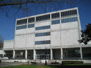
Marion County is a county located in the state of Oregon. The population was 315,335 Based on the 2010 census, making it the fifth-most
populous county in Oregon. The county seat is Salem, the state capital. The county was originally named the Champooick District, after
Champoeg (earlier Champooick), a meeting place on the Willamette River. On September 3, 1849, the territorial legislature renamed it in honor
of Francis Marion, a Continental Army general from South Carolina who served in the American Revolutionary War.
Marion County is part of the Salem, OR Metropolitan Statistical Area, which is also included in the Portland-Vancouver-Salem, OR-WA Combined
Statistical Area. It is located in the Willamette Valley.
Etymology - Origin of Marion County Name
Champoeg District was re-designated a county in 1845 and renamed Marion County in 1849 after General Francis Marion, a Revolutionary War hero.
Demographics:
County QuickFacts: CensusBureau Quick Facts
Marion County History
Marion County, originally named
Champooick District (later Champoeg), was created on July 5, 1843, by the
Provisional Legislature. Champoeg District stretched southward to the California
border and eastward to the Rocky Mountains. The area, however, was soon reduced
with the creation of Wasco, Linn, Polk, and other counties. Marion County's
present geographical boundaries, established in 1856, are the Willamette River
and Butte Creek on the north, the Cascade Range on the east, the Santiam River
and North Fork of the Santiam on the south, and the Willamette River on the
west.
The county shares political borders with Clackamas, Yamhill, Polk, and Linn
Counties. It contains 1,194 square miles. Champoeg District was redesignated a
county in 1845 and renamed Marion County in 1849 after General Francis Marion, a
Revolutionary War hero. That same year Salem was designated the county seat. The
territorial capital was moved from Oregon City to Salem in 1852. The ensuing
controversy over the location of the capital was settled in 1864 when Salem was
confirmed as the state capital.
Salem has had three county courthouses, all located on the same site. The first
courthouse was completed in 1854 and replaced in 1873. During the 1930s and
1940s efforts to move the 1873 building and preserve it as a museum failed and
it was demolished in 1952. The third and present courthouse was completed in
1954. Arson fires in 2005 cause severe damage to the courthouse, causing a long
closure before renovations were completed. The Courthouse Square Building next
to the courthouse was constructed in 2000 and houses many Marion County
administrative offices.
Marion County had a county court form of government for the first century of its
existence. The county court exercised a combination of executive,
administrative, and judicial functions; however as the judicial branch of state
government developed, the necessity for the county court to exercise judicial
functions diminished. In 1941 the county was divested of all judicial
responsibilities, and the remaining vestiges of probate and civil jurisdiction
were transferred to the circuit court. In 1961 the Legislative Assembly enabled
a county court with no judicial functions to reorganize as a board of county
commissioners. With court approval, the Marion County Court was abolished and
became the Marion County Board of Commissioners in 1963.
The 2000 population of 284,834 represented an increase of 24.66% over 1990. The
2006 population of 306,665 marked an increase of 7.7% over 2000.
The county is located in the center of the Willamette Valley. Agriculture and
food processing are important to the county's economy, as are lumber,
manufacturing, and education. Government, however, is the county's main employer
and economic base.
Geography: Land and Water
As reported by the Census Bureau, the county has a total area of 1,193 square miles (3,090 km2), of which 1,182 square miles (3,060 km2)
is land and 10 square miles (26 km2) (0.9%) is water.
Neighboring Counties
Bordering counties are as follows:
- Linn County (south)
- Polk County (west)
- Yamhill County (northwest)
- Clackamas County (north)
- Wasco County (northeast)
- Jefferson County (east)
Education
Marion County is the home of Willamette University, Corban University, and Chemeketa Community College.


Click Image to Enlarge
