


Click Image to Enlarge
Oregon Counties
There are thyirty-six counties in the state of Oregon. The Oregon Constitution does not explicitly provide for county seats.Morrow County, Oregon
Morrow County Education, Geography, and History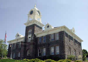
Morrow County is a county in the state of Oregon. Based on the 2010 census, the population was 11,173. The county seat is Heppner. The
county is named for one of its first white settlers, Jackson L. Morrow, who was a member of the state legislature when the county was created.
Half of the Umatilla Chemical Depot, which includes the Umatilla Chemical Agent Disposal Facility, is within the county.
Morrow County is part of the Pendleton–Hermiston, OR, Micropolitan Statistical Area. It is located on the south side of the Columbia River and
is included in the eight-county definition of Eastern Oregon.
Etymology - Origin of Morrow County Name
It was named after Jackson Lee Morrow an early settler in the area and member of the Legislative Assembly when the county was created.
Demographics:
County QuickFacts: CensusBureau Quick Facts
Morrow County History
Morrow County was created in 1885
from the western portion of Umatilla County and a small portion of eastern Wasco
County. It was named after Jackson Lee Morrow an early settler in the area and
member of the Legislative Assembly when the county was created.
Morrow County is located in the north central part of the state and east of the
Cascade Mountains. The county is bounded by the Columbia River on the north,
Umatilla County on the east, Grant County on the south, and Gilliam County on
the west. The county contains 2,049 square miles.
Heppner was designated the temporary county seat at the time the county was
created and narrowly defeated Lexington in the election held in 1886 to
determine the permanent county seat. Heppner was originally called Standsbury
Flat for George W. Standsbury, one of the first white settlers in the area. The
settlement's name was changed to Heppner in 1873, in honor of Henry Heppner who
in partnership with Jackson Morrow had established a store in the town a year
earlier.
The first courthouse was a frame structure completed shortly after Heppner was
confirmed as the county seat. In 1902, the wooden courthouse was torn down and
replaced the following year by the present courthouse, which is constructed of
native bluestone with sandstone trim.
Morrow County government consists of a county judge, two county commissioners,
district attorney, assessor, clerk, sheriff, surveyor, justice of the peace, and
treasurer-tax collector.
The Morrow Port District, situated on the Columbia River near the town of
Boardman, was established in 1958.
Early cattlemen found an abundance of rye grass along the creek bottoms of the
region and drove their herds into the area to forage on these natural pastures.
They established cattle camps and from them grew the county's first settlements.
Stock raising was the primary economic force in the county for many years.
Increased settlement, the enclosure of the free grazing lands and diminished
pastures due to overgrazing, resulted in the decline of ranching during this
century. Farming and other agricultural pursuits became predominant. The
completion of rail lines into the county in 1883 increased access to markets and
encouraged wheat production in the area. The principal industries in the county
today include agriculture, food processing, utilities (there is a coal fired
generating plant located in Boardman), lumber, livestock, and recreation.
Heppner was almost destroyed by a flood on June 14, 1903. The flood was
precipitated by a sudden cloudburst and accompanying hail that caused a dam
collapse and flash flooding. A wall of water and debris swept down the creeks
and canyons and through the town. It has been estimated that 247 people were
drowned. Property damage was reported at nearly $1,000,000. The nearby towns of
Ione and Lexington also sustained significant damage.
Morrow County experienced steady growth in population reaching a peak in 1920
with 5,617 people. The county's population declined in the following years and
did not surpass the 5,000 mark again until 1978. However, the 2000 population of
10,995 represented an increase of 44.20% over 1990.
Geography: Land and Water
As reported by the Census Bureau, the county has a total area of 2,049 square miles (5,310 km2), of which 2,032 square miles (5,260 km2)
is land and 17 square miles (44 km2) (0.8%) is covered by water.
Neighboring Counties
Bordering counties are as follows:
- Gilliam County - west
- Wheeler County - southwest
- Grant County - south
- Umatilla County - east
- Benton County, Washington - north
- Klickitat County, Washington - northwest
Education


Click Image to Enlarge
