


Click Image to Enlarge
Oregon Counties
There are thyirty-six counties in the state of Oregon. The Oregon Constitution does not explicitly provide for county seats.Umatilla County, Oregon
Umatilla County Education, Geography, and History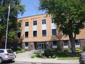
Umatilla County is a county located in the state of Oregon. Based on the 2010 census, the population was 75,889. The county seat is
Pendleton. The county is named for the Umatilla River.
Umatilla County is part of the Pendleton–Hermiston, OR Micropolitan Statistical Area. It is included in the 8 county definition of Eastern
Oregon.
Etymology - Origin of Umatilla County Name
Umatilla is an Indian term meaning "rippling water" or "water rippling over sand" and has provided the name both for the county and its major river.
Demographics:
County QuickFacts: CensusBureau Quick Facts
Umatilla County History
Umatilla County was created on
September 27, 1862, out of a portion of Wasco County. Umatilla is an Indian term
meaning "rippling water" or "water rippling over sand" and has provided the name
both for the county and its major river. Adjustments were made to the county's
boundaries following the creation of Grant, Morrow, Union, and Wallowa Counties.
The county contains 3,231 square miles and is bounded by the Columbia River on
the north, Morrow County on the west, Grant County on the south, and Union and
Wallowa Counties on the east.
The legislative act that created Umatilla County designated Marshall Station as
the temporary county seat. Umatilla City was chosen the county seat in an 1865
election. Population shifted to the north and east parts of the county due to
the opening of the Pendleton area to wheat production. A subsequent election in
1868 resulted in the selection of Pendleton as the new county seat, supplanting
both Marshall Station and Umatilla City.
The first courthouse was completed in 1866 in Umatilla City. The next
courthouse, and the first built in Pendleton, was a wooden, two-story structure
completed in 1869. In 1889 a three-story brick courthouse and jail was erected.
A fourth courthouse was built on the site of the old courthouse in 1956 and is
still in use today.
The government of Umatilla County consisted originally of a county judge, two
county commissioners, clerk, and sheriff. The offices of treasurer, assessor,
coroner, and superintendent of schools were added a short time after formation
of the county. The county judge position was abolished and a third commissioner
was added in 1975.
The first census of the Umatilla County in 1870 counted 2,916 inhabitants. The
population has increased steadily with a 2000 census figure of 70,548
representing an increase of 19.07% over 1990.
The Umatilla Indian Reservation was established by the Treaty of Walla Walla in
1855. It became an 800 square mile home for the Umatillas, Walla Wallas, and
Cayuse tribes and is located immediately southeast of Pendleton. The Umatilla
Confederated Tribes have 1,400 enrolled members.
Lewis and Clark and pioneers traveling the Oregon Trail passed through the area.
The gold rush of 1862 brought miners and stock raisers to the mountains and
grasslands of Umatilla County. The county expanded after the coming of the
railroad in 1881 and the area was open to the development of dry land wheat
farming. The fertile land of Umatilla County gives a strongly agricultural base
to the county's economy. Fruit, grain, timber, cattle, and sheep are important
agricultural products. Recreation, primarily in the Blue Mountains, and tourism,
most notably for the annual Pendleton Round-Up rodeo, are also important to the
local economy.
Geography: Land and Water
As reported by the Census Bureau, the county has a total area of 3,231 square miles (8,370 km2), of which 3,216 square miles (8,330 km2)
is land and 16 square miles (41 km2) (0.5%) is water. It borders the Columbia River across from Washington.
Neighboring Counties
Bordering counties are as follows:
- Benton County, Washington (north)
- Walla Walla County, Washington (north)
- Columbia County, Washington (northeast)
- Wallowa County (east)
- Union County (east)
- Grant County (south)
- Morrow County (west)
Education


Click Image to Enlarge
