


Click Image to Enlarge
South Carolina Counties
South Carolina is made up of fourty-six counties. They range in size from 392 square miles (1,016 square kilometers) in the case of Calhoun County to 1,358 square miles (3,517 square kilometers) in the case of Charleston County. The least populous county is McCormick County, with only 9,958 residents, while the most populous county is Greenville County, with a population of 395,357, despite the state's most populous city, Columbia, being located in Richland County.Charleston County, South Carolina
Charleston County Education, Geography, and History
Charleston County is a county located in the state of South Carolina. Based on the 2010 census, its population was 350,209, making it the
third-most populous county in South Carolina (behind Greenville and Richland Counties). Its county seat is Charleston. The county was created
in 1901 by an act of the South Carolina State Legislature.
Charleston County is included in the Charleston-North Charleston, SC Metropolitan Statistical Area.
Etymology - Origin of Charleston County Name
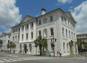
Charleston County and the city of Charleston, its county seat, are the most historic locations in the state. English settlers arrived in the colony of Carolina in 1670 and established a town at Albemarle Point on the west bank of the Ashley River. The settlement, named Charles Town in honor of King Charles II of England, was subsequently moved a few miles away to a peninsula between the Ashley and Cooper rivers. Charles Town (renamed Charleston in 1783) was the political, social, and economic center of South Carolina throughout the colonial and antebellum periods, and it served as the state capital until 1790.
Demographics:
County QuickFacts: CensusBureau Quick Facts
Charleston County History
Charleston County and the city of Charleston, its county seat, are the most historic locations in the state. English settlers arrived in the colony of Carolina in 1670 and established a town at Albemarle Point on the west bank of the Ashley River. The settlement, named Charles Town in honor of King Charles II of England, was subsequently moved a few miles away to a peninsula between the Ashley and Cooper rivers. Charles Town (renamed Charleston in 1783) was the political, social, and economic center of South Carolina throughout the colonial and antebellum periods, and it served as the state capital until 1790. Charleston District was formed in 1769, but portions were later split off to form Colleton (1800) and Berkeley (1882) counties. Present day Charleston County includes the old parishes of St. Philip, St. Michael, Christ Church, St. Andrew, St. John Colleton, and part of St. James Santee. English and French Huguenot settlers and their African slaves built indigo, rice, and cotton plantations along the area's rivers and on its sea islands, while merchants of many nationalities made Charleston one of the busiest ports on the Atlantic. During the Revolutionary War the American forces defeated the attacking British fleet at Charleston in June 1776; a palmetto log fort (later named Fort Moultrie) on Sullivans Island withstood the British cannon balls, and the palmetto tree was subsequently given a prominent place on the South Carolina flag. At another Charleston fort, Fort Sumter, federal troops were fired on by Confederate forces in April 1861, signaling the start of the Civil War. Charleston County has had many famous residents, including three signers of the United States Constitution: Charles Pinckney (1757-1824), Charles Cotesworth Pinckney (1746-1825), and John Rutledge (1739-1800). Other residents include architect Robert Mills (1781-1855), writers DuBose Heyward (1885-1940) and Archibald Rutledge (1883-1973), slave leader Denmark Vesey (1767-1822), abolitionists Sarah Grimke (1792-1873) and Angelina Grimke (1805-1879) , scientist Ernest Everett Just (1883-1941), and civil rights leader Septima Poinsette Clark (1898-1987).
Geography: Land and Water
As reported by the Census Bureau, the county has a total area of 1,358 square miles (3,517 km2), of which, 919 square miles (2,379 km2) of it is land and 440 square miles (1,139 km2) of it (32.37%) is water.
Neighboring Counties
Bordering counties are as follows:
- Berkeley County, South Carolina - north
- Georgetown County, South Carolina - northeast
- Colleton County, South Carolina - west
- Dorchester County, South Carolina - northwest
Education


Click Image to Enlarge
