South Carolina Counties
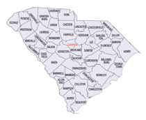
South Carolina is made up of fourty-six counties. They range in size from 392 square miles (1,016 square kilometers) in the case of Calhoun County to 1,358 square miles (3,517 square kilometers) in the case of Charleston County. The least populous county is McCormick County, with only 9,958 residents, while the most populous county is Greenville County, with a population of 395,357, despite the state's most populous city, Columbia, being located in Richland County.Horry County, South Carolina
Horry County Education, Geography, and History

Horry County is a county in the state of South Carolina. Based on the 2010 census, its population was 289,650, making it the fifth-most
populous county in South Carolina. The county seat is Conway.
Horry County is included in the Myrtle Beach-Conway-North Myrtle Beach, SC-NC Metropolitan Statistical Area. It is located in the Pee Dee
region of South Carolina, approximately 90 miles north of Charleston, South Carolina and approximately 130 miles east of the state capital,
Columbia.
Etymology - Origin of Horry County Name
This name honored Revolutionary War Hero, Peter Horry. Brigadier General Horry was born in South Carolina sometime around 1743 and started his distinguished military career in 1775 as one of 20 captains the Provincial Congress of South Carolina elected to serve the 1st and 2nd Regiments. In 1790 he was assigned to the South Carolina militia under Brigadier General Francis "Swamp Fox"Marion
Demographics:
County QuickFacts: CensusBureau Quick Facts
Horry County History
Horry County was named for Revolutionary War hero Peter Horry (1743-1815). The county was originally a part of Georgetown District, and at one time it was called Kingston. It became a separate county in 1801, with the county seat at Conway. This area of the state was isolated for many years by numerous rivers and swamps, and the inhabitants sometimes referred to themselves as the "Independent Republic of Horry." Lumber and naval stores were the primary industries during the eighteenth and early nineteenth centuries, with tobacco farming being introduced later. In the twentieth century, tourism has come to dominate the coastal section of the county centered around Myrtle Beach. Television personality Vanna White is a native of Horry County.
Geography: Land and Water
As reported by the Census Bureau, the county has a total area of 1,255 square miles (3,250 km2), of which, 1,134 square miles (2,936 km2) of it is land and 121 square miles (314 km2) of it (9.66%) is water.
Horry County is located in the northeastern corner of South Carolina. It is a diverse land made up of rivers, beaches, forest and swamps.
Horry County is bordered by the Atlantic Ocean to the east, the Little Pee Dee River and Drowning Creek (also known as the Lumber River) on
Horry's western side, and North Carolina to the north. Waccamaw River, approximately 140 miles (225 km) long, runs through southeastern North
Carolina and eastern South Carolina into Horry County. The river runs through the coastal plain, along the eastern border between the two
states, and into the Atlantic Ocean.
Neighboring Counties
Bordering counties are as follows:
- Columbus County, North Carolina - northeast
- Brunswick County, North Carolina - east
- Georgetown County, South Carolina - southwest
- Marion County, South Carolina - west
- Dillon County, South Carolina - northwest
Education


