


Click Image to Enlarge
Texas Counties
Texas is divided into two hundred and fifty-four counties, more than any other state. Texas was originally divided into municipalities, a unit of local government under Spanish and Mexican rule. When the Republic of Texas gained its independence in 1836, there were 23 municipalities, which became the original Texas counties. Many of these would later be divided into new counties. The most recent county to be created was Kenedy County in 1921. The most recent county to be organized was Loving County in 1931Andrews County, Texas
Andrews County Education, Geography, and History
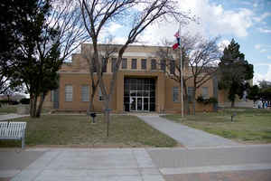
Andrews County is a county located in the state of Texas. Based on the 2010 census, the population was 14,786. Its county seat is Andrews.
Andrews is named for Richard Andrews, a soldier of the Texas Revolution. The county was created August 21, 1876, from Tom Green County and
later organized in 1910.
The Andrews Micropolitan Statistical Area includes all of Andrews County.
Etymology - Origin of Andrews County Name
Richard Andrews, the first Texan soldier to die in the Texas Revolution
Demographics:
County QuickFacts: CensusBureau Quick Facts
Andrews County History
Andrews County came into existence in 1876 while formed in 1875 from Bexar County when the 15th Legislature of Texas created 54
counties in the Panhandle and South Plains. It was named for Richard Andrews, the 1st man to die in the war for Texas independence in 1835.
Prior to 1890, the county was inhabited primarily by some ranchers, military personnel and Indians - Anasazi, Apache and Comanche. By 1900 the
population had reached 975 (mostly farmers and ranchers) with two communities—Shafter Lake and Andrews - in the county. Both communities
wanted to be the county seat, so, in order to woo voters, Shafter Lake gave lots to cowboys to enable them to vote for that town in the
election. But, when Shafter Lake refused to extend the deadline for the give-away for an individual, R. M. Means, whose wagon broke down on
the way to the town, the tide began to turn. Mr. Means returned to Andrews, bought land and began giving lots to cowboys as well. The election
was held on July 16, 1910 and Andrews won, beating Shafter Lake at its own game.
Handbook of Texas Online
The county was formed from Bexar County on August 21, 1876, a year after the first detailed explorations made by Col.
William R. Shafter from his military base at Fort Concho. The county was named for
Richard Andrews, a hero of the Texas Revolution
who was killed at the battle of Concepción in 1835. Subsequent boundary alterations occurred in 1902, 1931, and 1932.
For administrative purposes the area was placed within the jurisdiction of Shackelford County in 1876, within the Howard
Land District from 1882 to 1887, and within the Martin Land District from 1887 to 1891. The area was placed within the
jurisdiction of Martin County from 1891 until 1910, when Andrews County was formally organized with Andrews as its
county seat. More at
William R. Hunt, "ANDREWS COUNTY," Handbook of Texas Online (http://www.tshaonline.org/handbook/online/articles/hca02),
accessed January 23, 2016. Uploaded on June 9, 2010. Modified on January 22, 2016. Published by the Texas State Historical Association.
Geography: Land and Water
As reported by the Census Bureau, the county has a total area of 1,501 square miles (3,888 km2), of which,
1,501 square miles (3,887 km2) of it is land and 0 square miles (1 km2) of it (0.02%) is water. The county contains
many playa lakes, the two largest being Baird lake and Shafter Lake.
Neighboring Counties
Bordering counties are as follows:
- Gaines County (north)
- Martin County (east)
- Midland County (southeast)
- Ector County (south)
- Winkler County (southwest)
- Lea County, New Mexico (west)
Education
The Andrews Independent School District serves all of Andrews County.


Click Image to Enlarge
