


Click Image to Enlarge
Texas Counties
Texas is divided into two hundred and fifty-four counties, more than any other state. Texas was originally divided into municipalities, a unit of local government under Spanish and Mexican rule. When the Republic of Texas gained its independence in 1836, there were 23 municipalities, which became the original Texas counties. Many of these would later be divided into new counties. The most recent county to be created was Kenedy County in 1921. The most recent county to be organized was Loving County in 1931Bandera County, Texas
Bandera County Education, Geography, and History
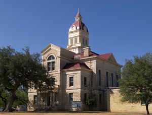
Bandera County is a county located on the Edwards Plateau in the state of Texas. Based on the 2010 census, the population is 20,485. Its
county seat is Bandera. The county was formed in 1856 from Bexar and Uvalde counties. The county and its seat are named for Bandera Pass,
which in turn uses the Spanish word for flag.
Bandera County is part of the San Antonio-New Braunfels, TX Metropolitan Statistical Area.
Etymology - Origin of Bandera County Name
Bandera is Spanish for "flag," and there are a number of colorful accounts as to how the county was named. One has it that a Spanish general named Bandera led a punitive expedition in the area against the Apaches after the Indians raided San Antonio de Bar. Another relates that after pursuing the Indians to Bandera Pass the Spanish left a flag or flags to warn them against future raids. And a third legend claims that in 1752 (or 1732) a council was held between Spanish and Indian leaders, during which the Spanish pledged never to go north of the pass if the Indians agreed to cease their raids in the south, and a red flag was placed on the pass as a symbol of the treaty.
Demographics:
County QuickFacts: CensusBureau Quick Facts
Bandera County History
Bandera County, formed in 1856 from Bexar and Uvalde counties. Bandera is named for the Spanish word for flag. Its county seat is Bandera.
In 1913 part of Bandera, Kerr, and Edwards Counties went to the formation of Real County.
1921 was the last year a county was formed in Texas
Handbook of Texas Online
In February 1855 sixteen Polish families arrived in Bandera to work in James and DeMontel's sawmill, and in
August of the same year August Klappenbach opened the first store and post office. On January 25, 1856, the
legislature marked off Bandera County from portions of Bexar County; the new county was formally organized on March
10, 1856. More at
Christopher Long, "BANDERA COUNTY," Handbook of Texas Online (http://www.tshaonline.org/handbook/online/articles/hcb02),
accessed January 23, 2016. Uploaded on June 12, 2010. Modified on January 22, 2016. Published by the Texas State Historical Association.
Geography: Land and Water
As reported by the Census Bureau, the county has a total area of 798 square miles (2,066 km2), of which, 792 square miles (2,051 km2) of it is land and 6 square miles (15 km2) of it (0.73%) is water.
Bandera County starts 25 mi northwest of San Antonio. It belongs to the Edwards Plateau region of southwest Texas
Bandera County is 792 square miles of rolling hills, scenic open land, magnificent cypress and cedar trees, lakes and rivers, with
elevations that range from 1,200 to 2,300 feet. The western part of the county is drained by the Sabinal River and the eastern part by the
Medina River. The Medina River runs from the northwest corner of Bandera County southeast into Medina Lake.
Neighboring Counties
Bordering counties are as follows:
- Kerr County (north)
- Kendall County (northeast)
- Bexar County (southeast)
- Medina County (south)
- Uvalde County (southwest)
- Real County (west)
Education
The following school districts serve Bandera County:
Bandera Independent School District
Medina Independent School District (partial)
Northside Independent School District (partial)
Utopia Independent School District (partial)


Click Image to Enlarge
