


Click Image to Enlarge
Texas Counties
Texas is divided into two hundred and fifty-four counties, more than any other state. Texas was originally divided into municipalities, a unit of local government under Spanish and Mexican rule. When the Republic of Texas gained its independence in 1836, there were 23 municipalities, which became the original Texas counties. Many of these would later be divided into new counties. The most recent county to be created was Kenedy County in 1921. The most recent county to be organized was Loving County in 1931Erath County, Texas
Erath County Education, Geography, and History
Erath County is a county located on the Edwards Plateau in the state of Texas. Based on the 2010 census, its population was 37,890. The county
seat is Stephenville. The county is named for George Bernard Erath, an early surveyor and a soldier at the Battle of San Jacinto.
Erath County is included in the Stephenville, Texas, Micropolitan Statistical Area.
Etymology - Origin of Erath County Name
George Bernard Erath, an early surveyor and a soldier at the Battle of San Jacinto
Demographics:
County QuickFacts: CensusBureau Quick Facts
Erath County History
Caddo tribe Anadarko villages were scattered along Trinity and Brazos Rivers. French explorer Jean-Baptiste Bénard de la Harpe developed
camaraderie among the Anadarko in 1719 when he established Fort Saint Louis de los Cadodaquious. The Anadarko became entangled with the French
battles with the Spanish and later the Anglos and suffered the consequences, including diseases for which they had no immunity. By 1860, these
tribes moved to Oklahoma. Erath County falls into Comancheria and found itself raided by Comanches until their removal to Oklahoma after 1875.
Erath County was formed from Bosque and Coryell counties in 1856 and named for George Bernard Erath, one of the original surveyors of the
area. In 1856, John M. Stephen offered to donate land for a townsite which was named Stephenville after him and became the county seat.
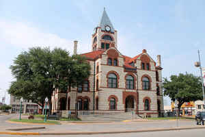
Erath's original 1866 wooden courthouse burned to the ground, destroying county documents along with it. A second stone courthouse was built
in 1877 but eventually razed. The cornerstone for the current courthouse was laid in 1891. The architects James Riely Gordon and D. E. Laub
designed the present three-story showcase Victorian structure. The building was completed in 1893, with limestone from the Leon River and red
sandstone from Pecos County. The building's centralized 95-foot tower has a bell tower and creates a chandeliered atrium from the first floor
to the third. The interior is east Texas pine, with cast and wrought-iron stairways, and tessellated imported marble floors. It was renovated
in 1988.
Handbook of Texas Online
The first attempts at settlement were made in 1854 by A. H. Dobkins and Will and Tom Holland near the site of
present-day Dublin. In the following year a party of thirty pioneers was brought into the area by surveyors George
Erath and Neil McLennan. Included in the group were John M. Stephen, his brother
William F., and a black family. The Stephens moved to the 4,409 acres of the John Blair survey, and the black family
may have been left alone in the post oak grove on the Bosque River, now the site of Stephenville, to establish
relations with Caddo and Anadarko Indians, who still visited the area from their new reservation in what is now
Young County. In 1856 John M. Stephen offered to donate land for a courthouse and townsite if the town was named
Stephenville and made the county seat. The state of Texas agreed and formed Erath County that year. More at
Dan M. Young, "ERATH COUNTY," Handbook of Texas Online (http://www.tshaonline.org/handbook/online/articles/hce06),
accessed January 23, 2016. Uploaded on June 12, 2010. Published by the Texas State Historical Association.
Geography: Land and Water
As reported by the Census Bureau, the county has a total area of 1,090 square miles (2,823 km2), of which,
1,086 square miles (2,814 km2) of it is land and 3 square miles (9 km2) of it (0.32%) is water.
Neighboring Counties
Bordering counties are as follows:
- Palo Pinto County (north)
- Hood County (northeast)
- Somervell County (east)
- Bosque County (southeast)
- Hamilton County (south)
- Comanche County (southwest)
- Eastland County (west)
Education


Click Image to Enlarge
