


Click Image to Enlarge
Texas Counties
Texas is divided into two hundred and fifty-four counties, more than any other state. Texas was originally divided into municipalities, a unit of local government under Spanish and Mexican rule. When the Republic of Texas gained its independence in 1836, there were 23 municipalities, which became the original Texas counties. Many of these would later be divided into new counties. The most recent county to be created was Kenedy County in 1921. The most recent county to be organized was Loving County in 1931Lampasas County, Texas
Lampasas County Education, Geography, and History
Lampasas County is a county located on the Edwards Plateau in the state of Texas. Based on the 2010 census, its population was 19,677. Its
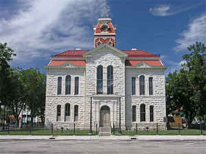
county seat is Lampasas. The county is named for the Lampasas River.
Lampasas County is part of the Killeen-Temple, TX Metropolitan Statistical Area.
Etymology - Origin of Lampasas County Name
the Lampasas River; Lampasas is Spanish for lilies
Demographics:
County QuickFacts: CensusBureau Quick Facts
Lampasas County History
Lampasas County is a county located in the US state of Texas. Its seat is Lampasas. The county is named for the Lampasas River.
Handbook of Texas Online
On February 1, 1856, in response to a petition signed by 135 Lampasas County citizens, the Sixth Texas
Legislature formed Lampasas County, named after the Lampasas River, from parts of Travis, Bell, and Coryell
counties. Burleson, renamed Lampasas, was made the county seat, and the new county was organized on March 10, 1856.
Two years later the northeastern corner of Lampasas County became part of Hamilton County. In 1873 an act of the
legislature extended the southern boundary of Lampasas County thirty miles into Burnet County, but the next year the
boundary was returned to its previous position. In 1887 the new Mills County received northern and northwestern
sections of Lampasas County. Subsequently, the county boundaries remained unchanged. Because the young county had no
resources to build a courthouse, county records were kept in a small frame building for a number of years, and there
were frequent turnovers in the county offices due to the small salaries offered. More at
Alice J. Rhoades, "LAMPASAS COUNTY," Handbook of Texas Online (http://www.tshaonline.org/handbook/online/articles/hcl03),
accessed January 24, 2016. Uploaded on June 15, 2010. Modified on December 9, 2010. Published by the Texas State Historical Association.
Geography: Land and Water
As reported by the Census Bureau, the county has a total area of 714 square miles (1,849 km2), of which, 712
square miles (1,844 km2) of it is land and 2 square miles (5 km2) of it (0.27%) is water.
Neighboring Counties
Bordering counties are as follows:
- Hamilton County (north)
- Coryell County (northeast)
- Bell County (southeast)
- Burnet County (south)
- San Saba County (west)
- Mills County (northwest)
Education


Click Image to Enlarge
